
Fann Mountains
Fann Mountains (also known as the Fanns) are part of the western Pamir-Alay mountain system and are located in Tajikistan's Sughd Province between the Zeravshan Range to the north and the Gissar Range to the south (see map of Fann Mountains). In the east-west direction they extend from Fandarya River to Archimaydan River, and the cluster of Marguzor lakes west of Archimaydan is also included in the Fanns.
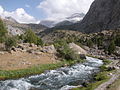
The Fanns boast about a hundred beautiful peaks, with several rising to altitudes of more than 5000 meters and relative elevations of up to 1500 meters. The highest point in Fann Mountains is Chimtarga peak (5489 m). Other 5000 m peaks are Bodkhona (5138 m), Chapdara (5050 m), Big Hansa (5306 m), Little Hansa (5031 m), Zamok (Castle, 5070 m), Mirali (5132 m), and Energy (5120 m). There are many beautiful lakes in the Fanns. The best known are Alaudin lakes in the Chapdara River valley, Kulikalon lakes on the northern slope of Chimtarga peak, Allo Lake, and the most outstanding of all Iskanderkul Lake.
The best time of the year to trek and climb in the Fanns is from the end the June to beginning of September, when the weather is exceptionally kind. Access is generally from Pendjikent, which can be reached either from Dushanbe or Samarkand.
Photo gallery
-
 Fann Mountais Trekking
 -
Chapdara and Bodhona Peaks
-
Alaudin lakes
-
Lake Moutniy
-
Chimtarga Peak
-
 People of Fanns
 -
 Village in Fann Mountains


Sources
Fann Mountains Mountaineering Photos. Tajikistan
External links
- Fann Mountains
- Mountains of the World
- Photographs of Fann Mountains
- Fann Mountains: photo gallery
- Mountaineering map of the Fanns
This Tajikistan location article is a stub. You can help Wikipedia by expanding it. |