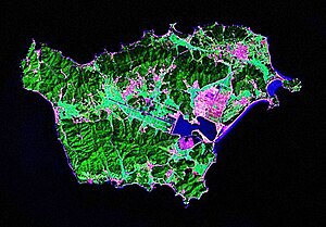
Baengnyeongdo
| Baengnyeongdo | |
 | |
| Korean name | |
|---|---|
| Hangul | 백령도 |
| Hanja | 白翎島 |
| Revised Romanization | Baengnyeongdo |
| McCune–Reischauer | Paengnyŏngdo |
Baengnyeong Island (sometimes spelled Baekryeong; Korean pronunciation: [pɛŋnjʌŋ-do]) is an island in Ongjin County, Incheon, South Korea, located near the Northern Limit Line, which is the maritime demarcation between North and South Korea.
The meaning of its name is "white wing island", since the island resembles an Ibis flying with the wings spread.[1]
Given its proximity to North Korea, it has served as a base for intelligence activity by the R.O.K. and the U.S.[citation needed]. Numerous North Korean defectors have also boated here to escape economic and political conditions in their homeland. In the recent past there have been several naval skirmishes between the two countries in the area.
National Treasures of South Korea #391–#393 are located on Baengnyeong Island.
Overview

Baengnyeong Island is the westermost point of South Korea. Travel time by boat to the island from Incheon is about four hours.[2]
Changsan Cape in Ryongyon, North Korea, can be seen from Baengnyeong on clear days.
Environment
The Chinese egret, which is considered to be one of the fifty rarest birds in the world, can be found here. Seals also make their homes on the beaches. [2]
Religion
Owing to the geographical location, Christianity went through Baengnyeong Island ahead of other Korean regions. After the Gabo Reform, Kim Seong Jin was exiled to this island, and the first church in Korea was established in 1896. There are ten churches in this small island at the present time.
Neigboring islands
Two smaller islands nearby are Daeeheong Island and the much smaller Socheong Island.
The ROKS Cheonan was hit by a torpeodo and sank near the island on March 26, 2010.
References
- ^ "네이버 :: 백과사전". 네이버. Retrieved 2006-05-16.
- ^ a b Template:Ko icon한국의 섬 (Islands of Korea)
- Malcom and Martz, White Tigers: My Secret War in North Korea, Brassey's. 1996
