Lübbecke Loessland


The Lübbecke Loessland (German: Lübbecker Lößland) is a natural region that is mainly situated in northeastern North Rhine-Westphalia but with a small area also lying in the western part of Lower Saxony in Germany. It is a belt of land, covered by loess, about 2 to 5 km wide and around 35 km long, that lies just north of the eastern part of the Wiehen Hills. The total area of the region is about 100 km². The Lübbecke Loessland is a transitional region between the North German Plain and the Central Uplands. To the north it borders on the Rahden-Diepenau Geest and, to the east, on the Middle Weser Valley. The town of Lübbecke lies in the centre of the region.
Administrative divisions
Administratively the Lübbecke Loessland includes the greater part of the parish of Bad Essen in the Lower Saxon district of Osnabrück, as well as Preußisch Oldendorf, Lübbecke, and Hille in the North Rhine-Westphalian district of Minden-Lübbecke, where Minden also has a small stake in the region.
Natural features
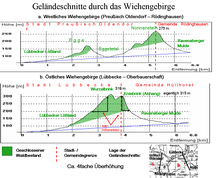
The Lübbecke Loessland is a Börde landscape that falls gently from south to north and is undulating in places. Whilst the southern boundary of the region is clearly defined by the edge of the forests on the Wiehen Hills, its transition to the Rahden-Diepenau Geest is rather more gradual. Only in the east is there a sharp dividing line to the Großes Torfmoor and the Bastau meadows. Its main characteristic is the rich loess soil that gives the region its name, and which was blown out of the sandur on the edge of the glacier during the last ice age and deposited on the northern slopes of the Wiehen.
Because of its outstanding loess soils the region is mainly used for arable farming. Grassland only occurs, if at all, on steep sections of the terrain, e.g. along the course of streams and, in places, immediately next to the forest edges on the Wiehen Hills. There are no large areas of woodland in the Lübbecke Loessland, just occasional small copses, some of which are protected, such as the Finkenburg Nature Reserve. Apart from the short streams that rise in the Wiehen Hills to the south and cut more or less straight across the Lübbecke Loessland without meandering, there are no significant natural waterbodies. Lakes and ponds only occur where pits or hollows have arisen in the course of quarrying for clay, and which have subsequently filled with groundwater or where men have laid out mill ponds in order to utilise water power. The Lübbecke Loessland begins in the north at about 50 metres above sea level and climbs towards the south, initially gently, but then increasingly steeply. The southern boundary, say on the forest edges of the Wiehen lies at between 100 and 130 metres above sea level. In other words, for example, in the area of the town of Lübbecke the region is steeper over a distance of about 1.5 kilometres than over the 150 kilometres from the northern edge of the area to the North Sea.
Source
- Emil Meynen (ed.): Handbuch der naturräumlichen Gliederung Deutschlands. Selbstverlag der Bundesanstalt für Landeskunde, Remagen 1959-1962 (Part 2, contains delivery nos. 6-9).
External links
- BfN landscape fact file
