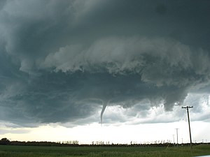
Funnel cloud

A funnel cloud is a funnel-shaped cloud of condensed water droplets, associated with a rotating column of wind and extending from the base of a cloud (usually a cumulonimbus or towering cumulus cloud) but not reaching the ground or a water surface. A funnel cloud is usually visible as a cone-shaped or needle like protuberance from the main cloud base. Funnel clouds form most frequently in association with supercell thunderstorms.
If a funnel cloud touches the ground it becomes a tornado. Most tornadoes begin as funnel clouds, but many funnel clouds do not make ground contact and so do not become tornadoes. Also, a tornado does not necessarily need to have an associated condensation funnel—if strong cyclonic winds are occurring at the surface (and connected to a cloud base, regardless of condensation), then the feature is a tornado. Some tornadoes may appear only as a debris swirl, with no obvious funnel cloud extending below the rotating cloud base. A funnel cloud is quite noticeable as it passes overhead aloft. The sounds heard are described as buzzing bees, roaring, a sucking sound, or a waterfall-like sound. A pressure drop is often noticeable as well, in the form of popping ears in anyone below the funnel cloud. A funnel cloud that touches down on, or moves over water is a waterspout.
Cold-air funnel clouds
Cold-air funnel clouds (vortices) are usually short-lived and generally much weaker than the vortices produced by supercells. Although cold-air funnels rarely make ground contact, they may touch down briefly and become weak tornadoes or waterspouts.

Unlike the related phenomenon associated with severe thunderstorms, cold-air funnels are generally associated with partly cloudy skies in the wake of cold fronts, where atmospheric instability and moisture is sufficient to support towering cumulus clouds but not precipitation. The mixing of cooler air in the lower troposphere with air flowing in a different direction in the middle troposphere causes the rotation on a horizontal axis, which, when deflected vertically by atmospheric conditions, can become a funnel cloud.[1]
They are a common sight along the Pacific Coast of the United States, particularly in the spring or autumn.[1]
See also
References
External links
- USA Today article on small vortices
- TORRO Tornado FAQ
- Cold-core waterspouts over Lake Michigan in fall 2006
- Bluestein, Howard B. (2008). "A Funnel Cloud in a Convective Cloud Line to the Rear of a Surface Cold Front". Monthly Weather Review. 136 (7). American Meteorological Society: 2786–95. Bibcode:2008MWRv..136.2786B. doi:10.1175/2007MWR2357.1.
{{cite journal}}: Unknown parameter|month=ignored (help)
