Tegart fort

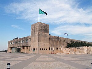
A Tegart fort is a style of militarized police "fortress" constructed throughout Palestine during the British Mandatory period.[1]
The forts are named after British police officer and engineer Sir Charles Tegart, who designed them in 1938 based on his experiences in the Indian insurgency. Tens of the reinforced concrete block structures were built to the same basic plan, both along the so-called "Tegart's wall" of the northern border with Lebanon and Syria, and at strategic intersections in the interior of Palestine.
Many of them stand to this day, and some continue to be used as jails.[2] Others are in use as police stations (e.g. in Rehovot and Ness Ziona). One is used for the controversial Camp 1391 prison for "high-risk" prisoners.[3]
The fort in Hebron was used successively as the headquarters of the Jordanian administration between 1949 and 1967, of the Israeli military governor between 1967 and 1997, and of the Palestinian Authority's governor between 1997 and 2002. It was destroyed in 2002 when the city was reconquered by Israeli forces in Operation Defensive Shield.
Alternate name
In Israel, Tegart is commonly misspelled as Taggart. [4] This is probably from the compound transliteration of an English name into Hebrew and then back into English. The latter spelling 'taggart' is used by Leon Uris in his epic novel Exodus.[5]
Existing examples of Tegart forts
- Latrun museum
- The Mukataa in Ramallah
- Jericho jail
- Akko police station
- Afula police station
- Kfar Sava police station
- Ness Ziona police station
- Rehovot police station
- Ramat Gan police station
- Metzudat Koach (Nebi Yusha fortress)
- Camp 1391
- Yoav Fort
References
- ^ "Charles Tegart and the forts that tower over Israel". BBC News, Jerusalem. Retrieved 10 September 2012.
- ^ Anton La Guardia, Jericho Jail Creates Own Modern History, LA Times, reproduced in Arab News, March 24, 2006 accessed at 2007-02-28
- ^ McGreal, Chris. Facility 1391: Israel's Secret Prison, The Guardian (14 November 2003). Accessed 27 February 2008.
- ^ A typical example of the misspelling of the name is: "The village [of Salha] was known for its Taggart [emphasis added] fort, which was built by the British in 1938 as a garrison fort at the height of the Arab rebellion, as part of the plan for building the "northern fence" to separate Eretz Israel from Lebanon. The fortress - like those in Nebi Yusha and in other locations in the Galilee - was named after British police officer and engineer Sir Charles Taggart, [emphasis added] who initiated their construction after have [sic] acquired experience in suppressing insurgencies in India." taken from Rubinstein, Danny (2006-08-06). "The seven lost villages". Haaretz. Retrieved 2007-02-28.
- ^ http://www.amazon.com/Exodus-ebook/dp/B005O3PL84/ref=sr_1_4?ie=UTF8&qid=1353590590&sr=8-4&keywords=exodus
33°06′55″N 35°33′22″E / 33.11528°N 35.55611°E
