
Alexanderplatz


Alexanderplatz (pronounced [ʔalɛkˈsandɐˌplats] ) is a large public square and transport hub in the central Mitte district of Berlin, near the Fernsehturm. Berliners often call it simply Alex, referring to a larger neighbourhood stretching from Mollstraße in the northeast to Spandauer Straße and the City Hall in the southwest.
Image gallery
-
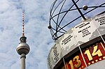 The World clock with the Fernsehturm in the background
 -

-
 Alexanderhaus
 -
 Project Blinkenlights
 -
 Shopping mall die mitte
 -
 Bahnhof Alexanderplatz and the Fernsehturm
 -

-
 Tram at Alexanderplatz
 -
 Fernsehturm on "Alex"
 -
 The World clock and Park Inn hotel in the background


References
Further reading
- Weszkalnys, Gisa. Berlin, Alexanderplatz: Transforming Place in a Unified Germany (Berghahn Books; 2010) 214 pages
External links
![]() Media related to Alexanderplatz at Wikimedia Commons
Media related to Alexanderplatz at Wikimedia Commons
| |||