Arabian plate


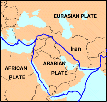
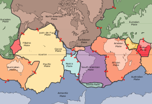
The Arabian Plate is one of three tectonic plates (the African, Arabian and Indian crustal plates) which have been moving northward over millions of years and colliding with the Eurasian Plate. This is resulting in a mingling of plate pieces and mountain ranges extending in the west from the Pyrenees, crossing southern Europe and to Iran forming the Alborz and Zagros Mountains, to the Himalayas and ranges of southeast Asia. [1]
The Arabian Plate consists mostly of the Arabian peninsula; it extends eastward at the Sinai and the Red Sea and northward to the Levant. The plate borders are:
- East, with the Indo-Australian Plate, at the Owen Fracture Zone
- South, with the African Plate to the west and the Indo-Australian Plate to the east
- West, a left lateral fault boundary with the African Plate called the Dead Sea Transform (DST), and a divergent boundary with the African Plate called the Red Sea Rift which runs the length of the Red Sea;
- North, complex convergent boundary with the Anatolian Plate and Eurasian Plate.
The Arabian Plate was part of the African plate during much of the Phanerozoic Eon (Paleozoic - Cenozoic), until the Oligocene Epoch of the Cenozoic Era. Red Sea rifting began in the Eocene, but the separation of Africa and Arabia occurred in the Oligocene, and since then the Arabian Plate has been slowly moving toward the Eurasian Plate.
The collision between the Arabian Plate and Eurasia is pushing up the Zagros Mountains of Iran. Because the Arabian Plate and Eurasia plate collide, many cities are in danger such as those in south eastern Turkey (which is on the Arabian Plate). These dangers include earthquakes, tsunamis, and volcanoes.

Notes
- ^ Image Science and Analysis Laboratory, NASA-Johnson Space Center. "Tectonics of the Arabian Plate". The Gateway to Astronaut Photography of Earth. NASA. Archived from the original on 6 July 2007. Retrieved 21 July 2007.
{{cite web}}: Unknown parameter|deadurl=ignored (|url-status=suggested) (help)

