
Talk:Control of cities during the Syrian civil war
| This is the talk page for discussing improvements to the Control of cities during the Syrian civil war article. This is not a forum for general discussion of the article's subject. |
Article policies
|
| Find sources: Google (books · news · scholar · free images · WP refs) · FENS · JSTOR · TWL |
| Archives: Index, 1, 2, 3, 4, 5, 6, 7, 8, 9, 10, 11, 12, 13, 14, 15, 16, 17, 18, 19, 20, 21, 22, 23, 24, 25, 26, 27, 28, 29, 30, 31, 32, 33, 34, 35, 36, 37, 38, 39, 40, 41, 42, 43, 44, 45, 46, 47, 48, 49, 50, 51, 52, 53, 54, 55, 56, 57, 58, 59, 60, 61, 62, 63, 64, 65Auto-archiving period: 7 days |
| This page is not a forum for general discussion about Control of cities during the Syrian civil war. Any such comments may be removed or refactored. Please limit discussion to improvement of this article. You may wish to ask factual questions about Control of cities during the Syrian civil war at the Reference desk. |
| This article is of interest to the following WikiProjects: | |||||||||||||||||||||||||||||||||||||||||||||
| |||||||||||||||||||||||||||||||||||||||||||||


.svg)
| To help centralise discussions and keep related topics together, Template talk:Syrian Civil War detailed map redirects here. |
Template:Syrian Civil War sanctions
|
Index 1, 2, 3, 4, 5, 6, 7, 8, 9, 10 |
|
This page has archives. Sections older than 7 days may be automatically archived by Lowercase sigmabot III when more than 4 sections are present. |
Syrian Army captured more Towns in North Hama
Syria TV report with subtittles. https://www.youtube.com/watch?v=5wx-VBCu4X0 — Preceding unsigned comment added by 190.203.137.34 (talk • contribs) 21:41, 3 October 2014
Al Qaeda is in All Green Towns
All Qaeda is in All Green Towns not only in Idlib Towns
The so called Islamic Front Was created by Al Qaeda member Abu Khaled al-Suri he was killed by the ISIS http://www.cbc.ca/news/world/syria-suicide-bombers-kill-al-qaeda-rebel-leader-in-aleppo-1.2548340
Even if you don't consider the islamic front as part of AQ, the nusra which is cleARLY AQ is in the vast majority of green areas.
SHouldn't a grey dot be put then within most of the greens (if it can be documented)? That could be used to show they are working together.
If hezbollah is the main garrison in any government town, I would understand putting a yellow dot within the red. Although I think they are primarily focused in a few areas, from what I've read.
— Preceding unsigned comment added by 72.252.161.166 (talk • contribs) 23:39, 13 November 2014
Menagh & northern Aleppo
A frightening situation , this article explains that FSA has withdrawn from Menagh and Nursa has taken control of this. It says fighting between Nusra and FSA has moved to Aleppo’s countryside. So it is not just in Idlib countryside now. http://www.al-monitor.com/pulse/originals/2014/11/jabhat-al-nusra-idlib-islamic-emirate.html — Preceding unsigned comment added by 72.252.161.166 (talk • contribs) 20:54, 13 November 2014
- Dozens of fighters from Jabhat al-Nusra pledged allegiance to the IS northeast of Aleppo.SOHR — Preceding unsigned comment added by Hanibal911 (talk • contribs) 21:25, 14 November 2014
Jaz'ah
According to SOHR's report http://syriahr.com/en/2014/11/7-militants-died-in-clashes-with-ypg-in-ras-al-ayn/ 2 villages(Mestriha and Felastin) south of Jaz'ah should be contested. — Preceding unsigned comment added by Saeed alaee (talk • contribs) 06:39, 18 November 2014
There we Go Again ...
And again we have pro-SAA editors change the Daraa and Quneitra map towards their own views without sources. I want the following questions answered with neutral sources:
1. Why was Dilli changed back to red and why is the 60th Engeneering Regiment nearby deleted as a green army base dot? 2. Why is the green circle around Mahajjah deleted, whilst SANA itself says there were bombings there, so rebels nearby? 3. Why is the city of Bosra changed from contested to red without a neutral source given? 4. There is a grey JaN ring in Nawa, whilst there is no infighting in southern Syria. So why the grey ring?! 5. Why is Tell Antar contested? No sources given
And before people start bombarding this post with PetroLucum or Al-Masdar stuff, I mean neutral sources. Al-Minotor wrote an article which states Sheikh Maskin and Brigade 82 should be green, as well as many towns north of it. We ignored it based on Al-Masdar reports (could as well listen to SANA). So, if that's the case, I will use Twitter sources from opposition activistst to change towns to green, since that is what pro-SAA people here do to contested and rebel towns in the south. — Preceding unsigned comment added by 84.24.43.183 (talk • contribs) 08:52, 19 November 2014
1- Dilli needs to be contested. The rebels took it, the regime counter-attacked and now clashes are happening inside the village. You used a totally pro-regime source to change it back to red. Also, SOHR reported 60th Batallion to be on rebel hands, so put it back(it's a small base, so maybe use a checkpoint icon).
2- Add the Daara Central Prison back, as it was AGAIN excluded. This is getting really boring.
— Preceding unsigned comment added by 179.183.246.229 (talk • contribs) 11:15, 19 November 2014
Happy New Year!


Sorry me guys that are off topic but still congratulate all!
- Happy New Year! Bonne Année! Glückliches Neues Jahr! سنة جديدة سعيدة! Buon Anno! Head uut aastat! Срећна Нова година! Sretna Nova godina! Mutlu Yıllar! Gëzuar Vitin e Ri! Laimīgu Jauno gadu! Naujųjų Metų! Hanibal911 (talk) 21:50, 31 December 2014 (UTC)
- Happy new year to all my fellow editors/users. It has been and will be a pleasure working with intellectual people like you. And may this year bring some peace to Syria and the Syrian people. ChrissCh94 (talk) 01:59, 1 January 2015 (UTC)
- Happy new year to you all, though not in my city (I live in Chicago), yet. Thanks for the efforts of this map.--Damirgraffiti |☺Say Yo to Me!☺ 04:53, 1 January 2015 (UTC)
- Happy new year everyone! XJ-0461 v2 (talk) 04:56, 1 January 2015 (UTC)
- Happy new year to you all, though not in my city (I live in Chicago), yet. Thanks for the efforts of this map.--Damirgraffiti |☺Say Yo to Me!☺ 04:53, 1 January 2015 (UTC)
- Happy new year to all my fellow editors/users. It has been and will be a pleasure working with intellectual people like you. And may this year bring some peace to Syria and the Syrian people. ChrissCh94 (talk) 01:59, 1 January 2015 (UTC)
not yet here in New Jersey. Alhanuty (talk) 04:00, 1 January 2015 (UTC)
- I wish everyone a Roshna Tota, which is a good year in Aramaic. Let me express a hope that this old language will still be heard in the years to come. GreyShark (dibra) 13:18, 1 January 2015 (UTC)
- Happy New Year fellas!! Boredwhytekid (talk) 15:03, 1 January 2015 (UTC)
- Happy New Year Guys(Gëzuar vitin e ri)and best of luck!Lindi29 (talk) 15:05, 4 January 2015 (UTC)
Happy New Year to everyone, may it bring some peace at last Kihtnu (talk) 09:37, 4 January 2015 (UTC)
Rebels vs IS, Damascus
There are no neutral sources about these events but i'll post what i have, so others can post their opinion. In this case it's either Rebel or IS sources.
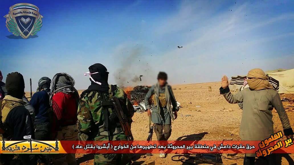
According to opposition activists, and opposition group channels (Al-Asala Tanmiya, Islamic Front, Al Rahmam corps, and other FSA groups), Rebels (Mainly IF and FSA) have expelled IS members from Rif Damascus area (including Bir Qassab and "Eastern Qalamun" now showed as JAN area).
- According to this photo, rebels (Authenticity and Development Front) are driving in Jayrud city after they expelled IS members. This is a bit confusing because according to our map, this city is shown as government held.
- FSA rebels with captured IS gear.
- On the right IS member using a captured TOW, and on the left rebels recaptured the same TOW after they advanced.
- On the right IS vehicle, and on the left rebels captured the same vehicle.
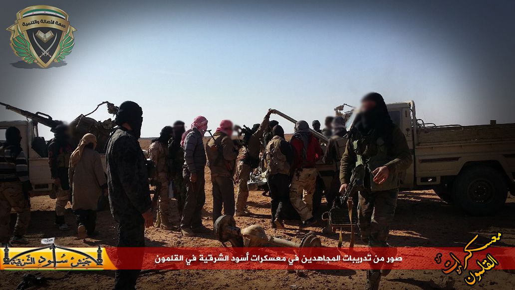
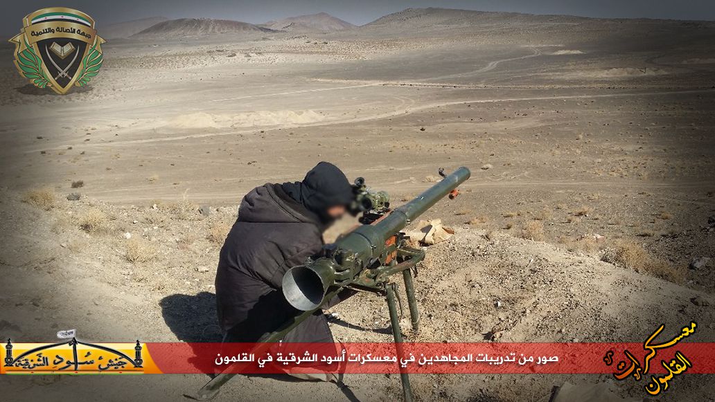
More pictures of rebels in Eastern Qalamun taking IS locations, 1, 2, 3, 4
- Video of rebels capturing an IS base in Bir Qassab
- Video showing a rebel commander statement that they took Eastern Qalamun, and naming the groups that participated (IF, Al Rahman, ADF .....).
So what is the point of all this, and lets say everything above is ok for you, i would edit these things : Bir Qasab and Al Busayri to green. Eastern Qalamun rural presence from grey to green, at least 70% of the factions there are not from JAN org. The thing about Jayroud town is really weird, maybe it's completely empty and rebels did capture it but i don't know. DuckZz (talk) 22:56, 1 January 2015 (UTC)
I follow the situation in Qalamoun since 1.5 year, my bet is on waiting til the winter ends, there are atleast 3000 of them(rebel,jan,IS etc) in Qalamoun, most of them will join IS maybe, they are surrounded by SAA/Hezbollah but not really, and the winter will be very harsh. It doesn't make sense to change anything in my opinion unless something remarkable happens. — Preceding unsigned comment added by Totholio (talk • contribs) 23:50, 1 January 2015 (UTC)
You are talking about things that are not related to this section. I'm not mentioning Western Qalamun and the mountains. DuckZz (talk) 00:08, 2 January 2015 (UTC)
- DuckZz We did talk about Jayroud earlier in this page, I helped find sources indicating that Jayroud is self-ruled by a local militia (not under the order of the NDF unlike Madaya where local rebels have been enrolled in the NDF) and not comprising any Nusra/ISIS elements. It was part of a deal between Jayroud citizens and the Dumeir Airport leader who threatens to shell the town if neighboring SAA CP's or bases come under attack from the East. Thing is Jayroud is under informal regime control. The pictures you showed confused me as well because I've been through all Qalamoun facebook pages and all I could find was: local truce but biased towards the regime (not as biased as the Madaya truce where rebels are basically under the command of the NDF, but not as free/strong as the truce in Ruhayba or Dumeir where the rebels are stronger and more independent and have more equal terms with surrounding regime forces). That's the reason we didn't signal Jayroud under truce. Because like Madaya it isn't THE truce as we know it. And also many pro-opp maps put it as regime-held so there you have it. ChrissCh94 (talk) 03:31, 2 January 2015 (UTC)
- DuckZz You did not provide any reliable sources. And you need remember that to for edit on the map need provide data only from reliable sources. Because data from the opposition sources we only can use if we want show the success army. Hanibal911 (talk) 08:53, 2 January 2015 (UTC)
- DuckZz We did talk about Jayroud earlier in this page, I helped find sources indicating that Jayroud is self-ruled by a local militia (not under the order of the NDF unlike Madaya where local rebels have been enrolled in the NDF) and not comprising any Nusra/ISIS elements. It was part of a deal between Jayroud citizens and the Dumeir Airport leader who threatens to shell the town if neighboring SAA CP's or bases come under attack from the East. Thing is Jayroud is under informal regime control. The pictures you showed confused me as well because I've been through all Qalamoun facebook pages and all I could find was: local truce but biased towards the regime (not as biased as the Madaya truce where rebels are basically under the command of the NDF, but not as free/strong as the truce in Ruhayba or Dumeir where the rebels are stronger and more independent and have more equal terms with surrounding regime forces). That's the reason we didn't signal Jayroud under truce. Because like Madaya it isn't THE truce as we know it. And also many pro-opp maps put it as regime-held so there you have it. ChrissCh94 (talk) 03:31, 2 January 2015 (UTC)
But that's it, you won't find any more sources than this. If you don't change things now, they will stay like this forever. I think Bir Qasab and Eastern Qalamun rural presence should go green. DuckZz (talk) 17:11, 2 January 2015 (UTC)
- DuckZz But it would be a gross violation of the rules of editing. Because we cant use data from the pro-opposition sources for display success of rebels. So need confirmation from reliable sources. Hanibal911 (talk) 18:25, 2 January 2015 (UTC)
- I agree with Hanibal911, more reliable sources should be acquired because the situation there is pretty unclear at the moment. EkoGraf (talk) 18:39, 2 January 2015 (UTC)
- I also agree with Hanibal911, thing is what we have now is the closest to the reliable reality on the ground. It might be different but we cannot prove it using reliable sources. All actual reliable sources point to what we already have on our map now, that's why I think things should remain unchanged at the moment ChrissCh94 (talk) 19:51, 2 January 2015 (UTC)
Still, I think we need to change the JAN grey area in Eastern Qalamun to green, as there is not much presence of Al Nusra, they are concentrated in Western Qalamun.
Rebels posted new pictures showing their fighters in
Also some videos : Captured ISIS fighters in Eastern Qalamun, Targeting Syrian army, Captured IS base in Eastern Qalamun. After all, the video in my first post clearly shows the rebel commander statement at the end of which groups are operating in this area, naming 5 different rebel and IF groups .. And yes, you will not find any other sources than this, neither JAN or Regime oriented, that's why we have a talk page, to determine which edit can be made despite some "rules" ... DuckZz (talk) 18:41, 3 January 2015 (UTC)
- DuckZz You must understand that it's all pro opposition sources we can not use them to display the success of rebels. So that we need confirmation those data from reliable sources. Because if we start use the pro opposition sources to show success of rebels then some other editors also start use pro government sources to show success of army. And as result we obtain unreliable map. So we need not prevent such a scenario. Hanibal911 (talk) 18:56, 3 January 2015 (UTC)
It's not a succes, they just changed roles. Why would any reliable source (news agency) write about this .. DuckZz (talk) 19:08, 3 January 2015 (UTC)
- Also pro opposition source reported that according to data from intelligence chief of Lebanon Islamic State send 700 new fighters to Qalamoun and is now strongest force in border mountains.here Hanibal911 (talk) 14:11, 4 January 2015 (UTC)
Umm Rumman Hill
The Umm Rumman hill (تل ام رمان) is falsely placed here. It is a hill directly overlooking Dumeir (الضمير) and the Baghdad-Damascus highway (طريق بغداد – دمشق):
![[1]](http://www.alhadathnews.net/wp-content/uploads/2014/11/qcdewc.jpg)
![[2]](http://www.alhadathnews.net/wp-content/uploads/2014/11/ewfewf1.jpg)
ChrissCh94 (talk) 23:51, 3 January 2015 (UTC)
- Hanibal911 Please correct it. ChrissCh94 (talk) 01:11, 5 January 2015 (UTC)
Kabajeb
This arch-pro opp source insists on showing Kabajeb and Al-Shulah under regime control Archicivilians. Is it time to indicate them as red? Kihtnu (talk) 09:41, 4 January 2015 (UTC)
Infighting inside city Douma
Islamist fighters seized a suburb east of Damascus after driving out a smaller rival insurgent group in deadly clashes. Fighters from the Army of Islam clashed with members of the Army of the Nation group in Douma, the Britain-based Syrian Observatory for Human Rights(SOHR) said. Both groups include Sunni Muslim fighters opposed to President Bashar al-Assad's government, and the fighting is seen as more of a turf war than a conflict over ideology. The Observatory, which gathers information from a network of sources in Syria, said several fighters were killed, without giving details. It added that the Army of Islam had detained many of its rival combatants. The groups, part of a myriad of opposition factions in the war, have both fought the Syrian army as well as battling each other for control of Douma, a strategic suburb on one of the main roads linking the capital with Homs city further north. Islamic groups such as Islamic State and al Qaeda's Nusra Front have benefited from the infighting and have emerged as some of the strongest factions in the conflict. ReutersThe Daily Star Hanibal911 (talk) 13:27, 4 January 2015 (UTC)
- Also pro opposition source reported that Jaish Al-Islam (Alloush)and Jaish Al-Umma (Abu Ali) are fighting each other in Douma.VivaRevolt Also reliable source said that Usud al-Ghouta (Lions of Ghouta) Damascus, surrender to Islamic Front and deliver all their weapons and military belonging Elijah J. Magnier and arrests Ahmad Taha, leader of Jaish al Umma and announces "he will terminate all bandits".Elijah J. Magnier Also Islamic Front issued a warrant against Nizar Khabbini of Jaish al Ummah (a group of 20 small rebels groups). Islamic Front is "cleaning" Duma/Jobar.Elijah J. Magnier Hanibal911 (talk) 14:23, 4 January 2015 (UTC)
- Jaish al-Islam finished off Jaish al-Ummah pretty fast within 6 hours. Their HQ's was taken and their commanders was captured or killed.Elijah J. Magnier 1500 members of Jaish al-Ummah are invited to join Islamic Fron within 24 hours.Elijah J. Magnier Hanibal911 (talk) 17:34, 4 January 2015 (UTC)
Barqa - Daraa Gov
Why is this town marked as rebel-held? These [3] [4] show it as regime held. ChrissCh94 (talk) 13:34, 4 January 2015 (UTC)
Pro-opp map is almost 1 month old, I think we changed it to green somewere in mid December. DuckZz (talk) 14:29, 4 January 2015 (UTC)
- DuckZzVillage Barqa was changed under rebels control on 18 Novemberhere So that according to pro opposition map we need mark this village under control by army. If we not have other confirmations that this village still under control by rebels. Hanibal911 (talk) 17:26, 4 January 2015 (UTC)
- Yes if we don't have reliable sources denying this we have to change Barqa to regime held. ChrissCh94 (talk) 18:02, 4 January 2015 (UTC)
Agree DuckZz (talk) 09:58, 5 January 2015 (UTC)
Deir er-Zor
According to SOHR IS militants are still fighting with the Regime Forces in al-jafra village,and violent clashes reported near 137 Brigade.here.Lindi29 (talk) 15:17, 4 January 2015 (UTC)
Free Syrian Army against Islamic Front
Free Syrian Army declared war on Islamic Front Zahran "to hunt him down wherever he is". Jaish al-Umma is over.Elijah J. Magnier Hanibal911 (talk) 20:47, 4 January 2015 (UTC)
The picture's fake, already confirmed by various groups (FSA linked) and opposition activists. Although it may be a declaration by a independent group, obviously not by the entire "FSA" southern front lol. DuckZz (talk) 22:02, 4 January 2015 (UTC)
- Source? XJ-0461 v2 (talk) 22:42, 4 January 2015 (UTC)
- Powerful rebel group Free Syrian Army based in Deraa province to the south, meanwhile, said the Islam Army deserved to be considered a “partner of the regime,” and highlighted the long-standing accusation that Alloush’s militia is not devoting enough resources to fighting against of the Syrian government forces.The Daily Star Hanibal911 (talk) 11:54, 5 January 2015 (UTC)
- So my data confirm another a reliable source. Free Syrian Army accused Zahran Alloush militia in the collaboration with the regime. Hanibal911 (talk) 12:02, 5 January 2015 (UTC)
- Al-Masdar confirms that FSA Central command has declared war on Jaysh Al-Islam: http://www.almasdarnews.com/article/rif-dimashq-rival-rebel-groups-declare-war-one-another/ XJ-0461 v2 (talk) 17:21, 5 January 2015 (UTC)
- So my data confirm another a reliable source. Free Syrian Army accused Zahran Alloush militia in the collaboration with the regime. Hanibal911 (talk) 12:02, 5 January 2015 (UTC)
- Powerful rebel group Free Syrian Army based in Deraa province to the south, meanwhile, said the Islam Army deserved to be considered a “partner of the regime,” and highlighted the long-standing accusation that Alloush’s militia is not devoting enough resources to fighting against of the Syrian government forces.The Daily Star Hanibal911 (talk) 11:54, 5 January 2015 (UTC)
Another prove that Al-Masdar is not reliable(SOHR also isn't). If the FSA and IF we're actually at war we would have news by now. Actually, they are fighting together in Aleppo(the new rebel advances in Aleppo wouldn't be possible without the Islamic Front and the Free Syrian Army working together). — Preceding unsigned comment added by 200.219.152.90 (talk) 01:43, 7 January 2015 (UTC)
- SOHR it is opposition source and if he said that now FSA opposed Islamic Front we trust this data. Hanibal911 (talk) 07:44, 7 January 2015 (UTC)
Maqsomah and Mafraq Seddiq (Hasakah Province)
SOHR (article here) reporting clashes between IS and YPG in the village Maqsomah (Maqsuma) west of Ras al- Ayn and also clashes between IS and SAA in the village Mafraq Seddig west of Hasakah. I can't find any of the two villages on the map. Can someone locate them and put them out, please? (YPG source for the clashes) Rhocagil (talk) 20:39, 5 January 2015 (UTC)
- RhocagilSOHR said that clashes between IS and YPG in an area near the village of Maqsomah in the countryside of Ras al- Ayn. SOHR not said that clashes inside Maqsomah.SOHR Carefully read the source! Hanibal911 (talk) 12:53, 6 January 2015 (UTC)
Hanibal911 there is no problem reading the source. The main problem for me is that it´s not on the map. You don't need to put it out contested or semi-sieged, but I still want it on the map. Maybee thou its hard to find (I can't find it on Google maps or wikimapia).
Other interesting news from the area from Al-masdar here is that it seems like village Mabrouka is under YPG control. YPG themselves reported a month (I think) ago that they where in control of the village, but no one else confirmed until now. I don´t know if Al-Masdar is a valid source for editing this? Rhocagil (talk) 14:52, 6 January 2015 (UTC)
In this map Mabrouka is not called Tal Mabrouka like in Al-Masdar article so it might as well be a nearby hill, can anyone with arabic knowledge check if there is that's the case in wikimapia?
186.116.26.93 (talk) 10:55, 7 January 2015 (UTC)
Khan Abu Shamat military complex
Who added this site as rebel-held? The only source that was used was the recent Archivilians map [5] known to be massively pro-opp. So please remove this site and only keep the Cement Factories as rebel-held since they were confirmed by regime sources in a previous discussion. The Archivilians map is quite inaccurate since it portrays Al Safa station, a gas station with a nearby restaurant, as a military complex. It shows the Battalion 559 still rebel-held despite rebel claims that they retreated etc. Therefore this map is not only biased but also inaccurate and cannot be used to display rebel-gains. So remove the rebel-held Khan Abu Shamat military complex but KEEP the rebel-held cement factories. ChrissCh94 (talk) 12:06, 6 January 2015 (UTC)
I added it, and here's the reason. Regime sources were informing about rebel presence in the complexes north-west or Sayal Airbase, someone added the cement factory but not the military complex right next to it. Another reason is the big number of pointless edits on this map in Qalamun and Daraa province without a clear source, hills are being added which are pointless, empty and never were used as a base or a checkpoint, same goes for unclear "storage" bases of something.
If you want to remove this rebel complex, then be prepared to remove dozens of other sites which are added because "Government or who else" , "probably" controls it. DuckZz (talk) 12:37, 6 January 2015 (UTC)
- Personally, my opinion is that we can leave on map this military object! I think we should not create a conflict situation due to a single object. But DuckZz also you need understand that if you in future will remove from map some objects without sources here this is will be regarded as vandalism. So I have to ask you not do this in future. Hanibal911 (talk) 13:05, 6 January 2015 (UTC)
I understand, i will open a section here for requests to remove some sites from the map which are added without source given or are pointless or both in most cases. DuckZz (talk) 13:21, 6 January 2015 (UTC)
- DuckZz Why the aggressiveness mate? You can review the Khan Abu Shamat talk section earlier in this page. Point is what you added was done without any sources. Yes rebels have a presence there, yes they have cut the Baghdad-Damascus highway and yes they do control points there. But I challenge you to find me one reliable source pointing out they controlled the military complex, a notorious detention center and CW storage facility. They did not even post 1 video on YouTube about it yet they flooded YouTube with videos on controlling the cement factories. You may add any rebel held military facility deep inside rebel-territory just as we did with both rebels (check the earlier talk section as well) and regime sites. You just cannot go and add a rebel-held site with an unclear status just because you want to or want to make a statement. I absolutely DO NOT AGREE on this one. It is simply against the map's rules. ChrissCh94 (talk) 13:31, 6 January 2015 (UTC)
- And besides we added both regime and rebel-held sites in a fair way. But it's not our problem if regime sites are more numerous because it makes perfect sense. Regime forces are the Syrian Army/regular forces and so most bases are theirs. Just because you don't like that fact doesn't mean you can go on and remove military bases just so they become equal in number to rebel-held bases. That isn't right. It is a fact on the ground that the Syrian Army still holds most military bases and you cannot alter that fact. I do however agree that we don't add random military non significant sites such as a random air-defense base in the middle of regime-held territory. But regiments and brigades are significant, the same goes for strategic hills/checkpoints or any military site on the front line. Again I advise you to check the section where we already discussed this issue. ChrissCh94 (talk) 13:39, 6 January 2015 (UTC)
Tottaly relaxed, don't know why you think that. I already said that there was no clear pro-government or neutral source about this, only from rebel and pro-rebel activist channels. That's why I like to open a section here so we can discuss if an edit can be made even if there is no pro-regime source confirming that, something that is maybe too obvious.
- I kinda thought not to add this complex but I have seen other editors ading pointless hills,facilities, bases etc. on the map without providing a clear source, so i thought this complex would be acceptable after all. I'm not reverting anyones edit, so do what you think it's the best. And yes, I have read the previous discussion and i'm not talking about those edits. DuckZz (talk) 13:47, 6 January 2015 (UTC)
- I got your point. But those hills, facilities etc. were added based on common sense. They sit deep inside regime territory. But the difference is that we added them to add strategic depth to out map. I was the one who suggested we add them. They were only 4 sites:
- Brigade 13 near Dimas that was bombed by Israel.
- Regiment 14 near Nabk showing that Eastern/Western Qalamoun are not totally connected.
- The AirDef Base near the border crossing overlooking the 2 VITAL highways of Homs-Baghdad and Damascus-Baghdad.
- And the Hosh AirDef Base that's bombing Zabadani and that was attacked by the rebels in the summer.
These are not irrelevant sites. Be sure I am very careful not to have a biased map. I was the one who convinced the editors to change Khazzanat to green, to show rebel presence near Madaya/Jayroud. I think this map is fair and accurate enough. But when you added this Khan Abu Shamat complex, you brought up an old consensus where we decided to add it back once we find reliable sources confirming who controls it. Personally I don't think the rebels control it because:
- It is a CW storage facility
- It is a secretive detention center that housed hundreds of captives
- It is well defended by surrounding bases
If the rebels captured it, we would have at least seen some pictures, some videos of this "horrible" place. Yet none were shown while YouTube was virtually spammed with videos of the nearby cement factories. That's my opinion. And also according to the map's rules I'm sorry but we cannot keep the Khan Abu Shamat. Feel free to find sources on the matter. ChrissCh94 (talk) 14:42, 6 January 2015 (UTC)
- As in the last conversation about this, this source is still the only authoritative one ever mentioning the site, and is my #1 reason to still swing towards keeping the military site in green on the map. Boredwhytekid (talk) 15:03, 6 January 2015 (UTC)
- Again it did quote a western Diplomat, not so authoritative. ChrissCh94 (talk) 16:04, 6 January 2015 (UTC)
- True, but it's the only source. We know the rebels took the cement plant, no doubt about that. And if they are able to "dominate the highway" from the cement plant, it stands to reason that the SAA isn't still in the buildings/base right next door. Boredwhytekid (talk) 16:48, 6 January 2015 (UTC)
- Well you have 2 airbases nearby and SAA isn't doing anything at all. And you said it, we only have this biased source. I'm still not convinced it is rebel-held that's why to avoid further arguments just remove it till we could find reliable source. This map is based on accuracy not hunches. You also agreed before on this and pretty much nothing has changed. ChrissCh94 (talk) 18:25, 6 January 2015 (UTC)
- As in the last conversation about this, this source is still the only authoritative one ever mentioning the site, and is my #1 reason to still swing towards keeping the military site in green on the map. Boredwhytekid (talk) 15:03, 6 January 2015 (UTC)
Right, now i'll write some places that, in my view, have no reason to be shown on this map and you can discuss if they are worth it.
- Umm Ruman (east to Dumayr), added on the map, why ?
- Tell Mutawwaq (north of Jasim), any source showing rebels or any kind of base on this hill ?
- Tall Qayta, small hill
- Tall Ayyubah, empty hill with hard rocks
- All Abod (south from Morek), destroyed building both by rebels and SAA, after they retook the south of this city. DuckZz (talk) 16:51, 6 January 2015 (UTC)
- Hey guys let we as a compromise leave on map this military base. I do propose not do from this big problem. If we find other data from the reliable or pro-opposition sources which confirm that rebels left this military object then in that case we can remove this base. But for now let them remain on the map. Hanibal911 (talk) 16:55, 6 January 2015 (UTC)
- DuckZz Here's some proof:
- Tall Ayyub it is military object(Army Base) this confirm pro opposition sourcehereherehere
- About Umm Ruman we have said in this discussionEastern Qalamoun Hanibal911 (talk) 17:18, 6 January 2015 (UTC)
- Also Al Aboud it is Military Checkpoint.here And where data that this checkpoint was destroyed. Hanibal911 (talk) 17:27, 6 January 2015 (UTC)
Tall Mutawaq had a small base/CP on its top and is rebel held. Umm Rumman hill was captured from the rebels not long ago. It's kinda like Observatory 45 in Latakia, used to monitor the nearby plains. I don't know much about the rest. People might complain about the numerous hills in Daraa but thing is they are mostly military sites built in case of an Israeli Invasion. Some were built after the civil war began. SAA is not naive enough to leave hills, monitoring vast areas, empty. This saves the SAA manpower. Instead of deploying 300 troops around a rebel held village, deploy 100 on a hill monitoring the village. Basic Logic. So most hills in Daraa (rebel or regime held) are indeed military sites. Personally I've been to Daraa and I've seen some of those hills, they do monitor large large areas. I don't think we should remove them no matter who controls them. But again about the Khan Abou Shamat complex, nothing new has occurred no new sources were provided. We compromised and agreed before to remove it so now what has changed? Nothing has changed so why add it back?! Doesn't make any sense. ChrissCh94 (talk) 18:25, 6 January 2015 (UTC)
- [6] The area is also called the Scientific Research Battalion by the Syrian activists/rebels because as Wikimapia and activists describe it, it contained Biological-Chemical research possibly on humans. An activist on Wikimapia also saying that the rebels retreated after finding it completely empty and deserted.
- While here [7], a rebel source on the 4th of May says that rebels are shelling the Chemical Research Facility 2 days AFTER Reuters said they captured the facility [8]. How could the rebels shell something they captured? While I'm not insisting we revert it back to regime-held, I also do not approve that we keep it rebel held --> Consensus: Remove it from the map. Hanibal911 Boredwhytekid And don't play on the words Chemical storage/Chemical Research facility. It is the SAME or BOTH considering how secretive the facility must have been. ChrissCh94 (talk) 11:21, 7 January 2015 (UTC)
Al Shulah
ilooked at Wikimapia and I realised that it is literally nothing but there is a gas station next to it — Preceding unsigned comment added by 94.66.142.235 (talk) 14:02, 6 January 2015 (UTC)
Abu Shafiq (Morek)
This guy (pro-rebel, pro-Ukraine lol) tried to show the front line west from Morek. According to him, it's right there and it does look like that.
- Thoughts ? This is just an indication and not a source because i know the rules. DuckZz (talk) 20:35, 6 January 2015 (UTC)
- I would look at the video referenced, to see if it indicates a real presence. (i.e. more than just someone with a camera). If so, it should be taken as adequate info, since the image shown clearly corresponds with points indicated on the map. It is not just lines on a map, nor just an unclear video. It would be a map backed by collaborating video evidence. And not just an unsubstantiated declaration, which is commonly accepted for changes on our map, if from a "reliable source".
- Note that such correspondence is not available with most videos. This source is doing useful research to present this info.
- This would allow us to put a green semicircle to the west. My 2 cents ... André437 (talk) 12:57, 8 January 2015 (UTC)
- This biased the antigovernment source which we cant use in this issue. So that we need confirmation this data from more reliable source. And do not say that this source is reliable. He is not reliable source! Hanibal911 (talk) 13:31, 8 January 2015 (UTC)
- Your getting a little confused. The source presents a video which can be independently downloaded from internet, along with a map, showing his geolocation analysis. We can very easily confirm the geolocation analysis, so there is unrefutable evidence that the image was taken from the location indicated. Viewing the video should confirm that there is indeed a rebel presence in the area. (Unfortunately a configuration problem on my computer means I can't view the video at the moment.)
- This is far from unsubstantiated claims. It doesn't matter how reliable we consider the source for other types of evidence. Think for a moment. How could any evidence possibly be more reliable ? André437 (talk) 23:21, 8 January 2015 (UTC)
As_Sa'an in Hama
Official NDF page reported rebel attacks on SAA/NDF positions near the town. Not the first of its kind. Should we add a green semi-circle to the north from the side of Rahjan? [9] ChrissCh94 (talk) 23:07, 6 January 2015 (UTC)
- It is just hit and run in this area. So dont need put semi-circle because we put this mark if we have several reports about clashes near city or village. Hanibal911 (talk) 07:47, 7 January 2015 (UTC)
- Yes but it is not the first time, if we have multiple hit and run raids shouldn't we put a semi-circle? ChrissCh94 (talk) 10:49, 7 January 2015 (UTC)
Green semi-circle above Sa'an would make sense there is one above Jubb Khasarah south of Sa'an so how about moving it north to show current situation .81.156.226.104 (talk) 13:30, 7 January 2015 (UTC)pyphon
- If reports of clashes near the city repeated then we put semi-circle. Because source not said that clashes near of this town still going likely it is only hit and run and but nothing more. Because if every time we on the bases of only one report about shootout near the town or village we will put semicircles in a short time the majority of towns and villages will be with such mark. We have already discussed it and decided to put a mark if the reports of clashes repeated several times. We have put such semicircle near the village of Jubb Khasarah only based on one message but there were no more reports about clashes near this village. So dont need to rush. Hanibal911 (talk) 14:03, 7 January 2015 (UTC)
Nubl and Zahraa
SOHR reports has talked aout clashes inside Nubl and Zahraa,but i believe more confirmation and reports must come inorder to change them contested any other opinions
https://www.facebook.com/syriahroe/posts/638641326244209.Alhanuty (talk) 22:38, 7 January 2015 (UTC)
SOHR has a very bad English translation. The clashes are most likely in the towns outskirts. Nubl and Zahraa are fortified enough to hold any rebel offensive for quite sometime. — Preceding unsigned comment added by 200.219.152.90 (talk) 23:24, 7 January 2015 (UTC)
- In original article SOHR reported that clashes in the vicinity the towns of Nubl and Zahraa between Islamic battalions and combat brigades and Al-Nusra fighters (al-Qaeda in the Levant) of the party, and the National Defence Forces and local gunmen.SOHR Hanibal911 (talk) 08:24, 8 January 2015 (UTC)
- So that in the future will be better before edit find the original report. Since the reports which we read in the SOHR page in Facebook may differ from the original reports! Hanibal911 (talk) 08:31, 8 January 2015 (UTC)
I want to make an industrial complex icon right here. SOHR and other channels are always mentioning this area when talking about Zahra and Nubl clashes.
- Also there's a Silk factory in this complex right here, so it would be plausible to make this icon which includes this factory and area around it.
- According to rebel channels, regime forces control this area and rebels are shelling them with mortars. Here's a video, on the left you can see the white buildings. DuckZz (talk) 17:12, 8 January 2015 (UTC)
We should keep a eye on Nubl and Zahra. Nusra terrorists and IF launched a new offensive. — Preceding unsigned comment added by 177.97.166.52 (talk) 18:59, 8 January 2015 (UTC)
Hanibal911 Last night every attack was repeled by the SAA & NDF forces, dozens of dead JAN members, but they started another offensive this evening and they advanced towards the mid square of Al-Nubl. New map posted 2 hours ago. DuckZz (talk) 21:39, 8 January 2015 (UTC)
- DuckZzPro government source here and pro opposition source here showed that clashes on the outskirts of the town Nubl. Syrian troops backed by NDF and Hezbollah already smashed two of three attacks on towns of Nubl and Zahraa and inflicted heavy casualties of Al Nusra. Last attack ongoing takes place to southeast of Al-Zahraa. Battle raging about 300 meters from the towns outskirts.herehere Also the reliable source reported that Al Nusra didn't managed to break into the East side of Al Zahraa despite claim on social media.Elijah J. Magnier Because in Nubl and Al Zahraa have more or less 6,000 fighters.Elijah J. Magnier Their last attack was repulsed.Elijah J. Magnier Hanibal911 (talk) 22:06, 8 January 2015 (UTC)
- Also a reliable source reported that activists from the town Al Zahra denied report about Al Nusra advance in town of Nubl. Elijah J. Magnier Hanibal911 (talk) 22:19, 8 January 2015 (UTC)
I am really confused. Now Al Jazeera is saying that rebels control 50% of Al Nubl lol. Hard to belive really but lets wait a couple of days. We know that rebels have a strong media, they will probably provide some photos/videos from inside the city if confirmed. DuckZz (talk) 22:33, 8 January 2015 (UTC)
- I have not found messages from Al Jazeera in which says that rebels control 50% of town Nubl. About this only said biased the antigovernment source Archicivilians here but anyway the reliable source reported that all Al Nusra attacks was repelled. Hanibal911 (talk) 22:42, 8 January 2015 (UTC)
Bur SOHR reported that Nusra entered the towns for the first time,what do you suggest to be done,then Hannibal.Alhanuty (talk) 23:47, 8 January 2015 (UTC)
- Since so many other sources have said that the attack failed, nothing will be done until more time has passed. XJ-0461 v2 (talk) 01:30, 9 January 2015 (UTC)
- Alhanuty But another a reliable source reported that attack was repelled and Al Nusra not entered to the town.Elijah J. MagnierElijah J. Magnier And SOHR reported that al- Nusra and Islamic battalions could take control over streets in the south of the town al- Zahraa and buildings in the east town of Nubl but NDF and local gunmen from the two towns could re-take these streets and building.SOHRSOHR Also pro opposition source reported that rebels still far away from Zahraa.here Hanibal911 (talk) 07:35, 9 January 2015 (UTC)
- According to the SOHR the insurgents were briefly able to control streets in the southern part of Zahra and buildings in the nearby village of Nubl, north of city Aleppo. But the militants, who used tanks, were pushed back from both areas by the National Defense Force, a grouping of loyalist militias under the umbrella of the army.The Daily Star Hanibal911 (talk) 09:14, 9 January 2015 (UTC)
- Also pro opposition source said that Al-Nusra insurgents seized several streets in the southern part of the village of Zahra and buildings in the nearby village of Nubl, north of the city of Aleppo. But activist Hazim Yunis in Aleppo reported that pro-Assad forces of the National Defense were able to push the al-Nusra fighters back on evening.ARA News Hanibal911 (talk) 09:13, 10 January 2015 (UTC)
- According to the SOHR the insurgents were briefly able to control streets in the southern part of Zahra and buildings in the nearby village of Nubl, north of city Aleppo. But the militants, who used tanks, were pushed back from both areas by the National Defense Force, a grouping of loyalist militias under the umbrella of the army.The Daily Star Hanibal911 (talk) 09:14, 9 January 2015 (UTC)
- Alhanuty But another a reliable source reported that attack was repelled and Al Nusra not entered to the town.Elijah J. MagnierElijah J. Magnier And SOHR reported that al- Nusra and Islamic battalions could take control over streets in the south of the town al- Zahraa and buildings in the east town of Nubl but NDF and local gunmen from the two towns could re-take these streets and building.SOHRSOHR Also pro opposition source reported that rebels still far away from Zahraa.here Hanibal911 (talk) 07:35, 9 January 2015 (UTC)
- Syrian pro-regime militia have repelled an incursion by al-Qaida on two Shiite Muslim villages in the north of the country.
The villages of Nubol and Zahraa in Aleppo province had been under siege by Al-Nusra Front, al-Qaida's Syria branch, and other Islamist rebels for a year and a half. SOHR said that Al-Nusra fighters entered the villages on seven tanks. It was a major, simultaneous attack. The National Defence Force, a pro-government militia, repelled the attack with support Syrian air force and jihadists withdrew.NaharnetDaily MailArab TodayAD-HOC NewsReuters Hanibal911 (talk) 09:26, 10 January 2015 (UTC)
Ma‘arrat Umm Hawsh and Harjalah
According to data from pro opposition source those villages under cpntrol by moderate rebels. Personally, I believe that these villages under the control of moderate rebels. Hey guys if have someone of you have other data you can provide their. Hanibal911 (talk) 08:51, 9 January 2015 (UTC)
Harjalah should stay as it is. IS probably withdrew from Marat Hawsh after rebels recaptured Mare, looking at the map its just logical to mark it as green. DuckZz (talk) 11:49, 9 January 2015 (UTC)
- DuckZz You are right! So if there is no other objection, we can note this village under rebel control. So if no objections, we can note it village under rebel control. Hanibal911 (talk) 12:06, 9 January 2015 (UTC)
- Also maybe some one of editors to have data about situation in village of Al-Ghafer in Idlib province which located deep area which under control by Al Nusra and some rebel groups. Antigovernment source showed that it is village under control by antigovernment forces.deSyracuse Hanibal911 (talk) 13:04, 9 January 2015 (UTC)
Afrin Area
Interesting fact, 2 opposition sources saying a regime convoy from Afrin was intercepted. I thought Afrin was entirely YPG-held. Any opinions, news, info on the matter? [10] [11] [12] ChrissCh94 (talk) 10:46, 9 January 2015 (UTC)
- Another source, pro-opp Kurd source saying regime forces were arresting people returning TO AFRIN FROM DAMASCUS. [13] So I guess Afrin is under a truce? Kinda like Qamishli? It explains how the regime forces in Mennagh airbase were able to escape. Opinions? ChrissCh94 (talk) 11:07, 9 January 2015 (UTC)
- Last year, after the Menahg Airport was captured a rebels some soldiers retreated to this area.here Hanibal911 (talk) 11:19, 9 January 2015 (UTC)
Not really. Afrin is controled mostly by local kurdish groups, not really YPG, they don't want trouble with anyone so they allow free movement for rebels and regime forces inside their territory (certain conditions), confirmed after SAA withdrew from Menagh, confirmed after rebels started their offensive against ISIS last year.DuckZz (talk) 11:47, 9 January 2015 (UTC)
- Explain how a regime convoy was coming from Afrin yesterday? ChrissCh94 (talk) 12:55, 9 January 2015 (UTC)
Any reliable source ? No, as far as i know. DuckZz (talk) 13:06, 9 January 2015 (UTC)
- Guys the sources I provided are from YESTERDAY! I am not talking about Menagh I just used it as an additional example. The sources I provided indicated regime presence in Afrin. That was my point. DuckZz Hanibal911 ChrissCh94 (talk) 14:05, 9 January 2015 (UTC)
Afrin is obviously Kurdish held. Those sources have to be crazy. Also, what is that village near Nubl and Zahraa? If the regime had ANY villages near those towns, they would be annoucing it or Nusra would be attacking them. The Kurds hold all territory west of those Shia towns, and there are no convoys coming from Afrin. — Preceding unsigned comment added by 179.183.254.109 (talk) 15:28, 9 January 2015 (UTC)
- I agree with 179.183.254.109. We only have an unsubstantiated claim that any regime convoy came from Afrin. A look at the map shows how improbable the non-kurd rebels could have had any access to such a convoy, as Afrin covers the entire north and west sides of the regime enclave.
- As for the Menagh retreat 2 years ago, the kurds captured the regime convoy, including some 200 troops, numerous transport vehicles. and 3 tanks. (Giving all kurdish forces 4 tanks.) The regime had probably hoped that the kurds would let them pass. They probably wouldn't have made it to regime held areas in Aleppo city. André437 (talk) 16:03, 9 January 2015 (UTC)
- A small clarification! Menagh Air Base was captured 6 August 2013. Just wanted to clarify because was said that the base was captured two years ago.here Hanibal911 (talk) 16:45, 9 January 2015 (UTC)
- Alright all opinions respected. But why do you think would activists claim this? Propaganda? What about the checkpoints arresting poeple coming to Afrin? I also thought it was improbable but I thought it was worth the discussion. ChrissCh94 (talk) 16:48, 9 January 2015 (UTC)
- A small clarification! Menagh Air Base was captured 6 August 2013. Just wanted to clarify because was said that the base was captured two years ago.here Hanibal911 (talk) 16:45, 9 January 2015 (UTC)
- @Hanibal911: Point taken. That 17 months felt like 2 years ...
- @ChrissCh94: There are a lot of mixed emotions in this conflict, and many activists probably still have mixed feelings about the kurds and possible separatism. (Despite kurdish statements favouring a federal system for all of Syria.) So they fantasize a bit.
- As well, we can't exclude propaganda, particularly on the part of more extremist regime opponents. Such as has been done in Raqqa by Daesh, Idlib and northern Homs by Nusra, and Damascus eastern Ghouta by Islam Army, to justify attacking their strongest anti-regime competitors/opponents. To give just a few examples.
- Also, this particular claim is likely just based on a single source, picked up by both archicivilians (who only presented it as an activist claim) and al-Arabiya. André437 (talk) 18:27, 9 January 2015 (UTC)
- Alright good call. Proves my point that not all sources are reliable as they may appear to be. ChrissCh94 (talk) 19:35, 9 January 2015 (UTC)
Area to west from city of Hasakah
Pro-opposition source said that loyalists seized some towns to IS in area between mount Abdel-Aziz and Khabur valley. And that this area under the protection of YPG and Loyalists.deSyracuse (of 8 January) So i noted village Khuraytah under control by army and YPG and I think that we also need noted under the joint control army and YPG some other villages in this area. Hanibal911 (talk) 11:43, 9 January 2015 (UTC)
Talbiseh
Pro opposition source said that clashes break out between Syrian Army and opposition fighters in city Talbiseh in Homs countryside.DocumentSyDocumentSy So that guys maybe some one of editors to have other data about situation in this city. Hanibal911 (talk) 13:16, 9 January 2015 (UTC) Fighting in this town has been reported several times in the recent past. I guess from SOHR. See also [14] (pro-opp). It is maybe time to turn it into contested.Paolowalter (talk) 15:38, 9 January 2015 (UTC)
- But also earlier 23 December pro opposition source reported that clashes took place between FSA and regime troops in the outskirts of the city of Talbiseh.Revolutionary Forces of Syrian Media Office Hanibal911 (talk) 16:56, 9 January 2015 (UTC)
- Talbiseh is a rebel stronghold. It is not contested. Just south of the city there is the Malouk army complex from which army troops attack the southern border of the city. This has been going on for months, but the rebels are holding up well... so the city is not contested & the clashes can still be reported routinely for months in the future along the same pattern. No evidence that army troops can do anything other than hit & run attacks. The red semi-circle is enough for now. Tradediatalk 06:34, 10 January 2015 (UTC)
- How do you know that?Paolowalter (talk) 14:32, 10 January 2015 (UTC)
- See [15].
Paolowalter (talk) 21:54, 10 January 2015 (UTC)
Amateur maps.
In 3 days time with nothing but an amateur map as a source, 16 red villages, 4 red villages, 6 red villages, 9 red villages, 5 red bases, 1 red base, 6 red bases, 2 red bases, 4 red bases, Khirbat al Atrah to red (which is a joke - to show any SAA-held village in NW Aleppo as NOT besieged), Hawsh Haju to red. How many of those actually add anything of consequence to the map? Are any corroborated by any other source? It's just a piling on of inconsequential red clutter, in most cases*.. Boredwhytekid (talk) 19:34, 9 January 2015 (UTC)
well it does provide a more accurate view of what sides hold villages and a large part of the population centers. If small IS held dessert villages are marked on the map, why cannot larger villages in Latakia and other areas also be included? — Preceding unsigned comment added by 169.231.156.148 (talk) 19:55, 9 January 2015 (UTC)
- Because before the tiny IS villages our map didn't show that IS indeed held the territory, though it was common knowledge that it was. Adding villages in Latakia doesn't do anything but add more of the color red, since we already know and show Latakia as SAA held (NE section excluded).
- Boredwhytekid We use pro opposition maps to show army success. So that dont need each time start one and the same discussion. Also on this map clearly indicated names of all military installations that I added. After all, we are also use the pro government maps to show the success of the rebels. Hanibal911 (talk) 21:27, 9 January 2015 (UTC)
- I cant understand why when we use pro-government maps to show the success of the rebels, no one is objection. But as soon as we use pro-opposition maps to show success army then some one of editors immediately begin objections saying that need another confirmations from other sources. Hanibal911 (talk) 21:53, 9 January 2015 (UTC)
- And this edit which I was made was need to show more detaled situation in this areas. We earlier also for improve on map add without specifying sources the several villages and military objects under control by rebels in Idlib and Aleppo province. And we all agreed with this and there were no objections. But when for improve on map and on the basis of data from pro-opposition map I added some villages and military facilities that are under the control of the army as it caused a protest. So I not violated the rule of edit because as we all agreed to use pro-government maps to show the success of the rebels and pro-opposition maps to show the success of army. Hanibal911 (talk) 22:33, 9 January 2015 (UTC)
- I cant understand why when we use pro-government maps to show the success of the rebels, no one is objection. But as soon as we use pro-opposition maps to show success army then some one of editors immediately begin objections saying that need another confirmations from other sources. Hanibal911 (talk) 21:53, 9 January 2015 (UTC)
- Boredwhytekid We use pro opposition maps to show army success. So that dont need each time start one and the same discussion. Also on this map clearly indicated names of all military installations that I added. After all, we are also use the pro government maps to show the success of the rebels. Hanibal911 (talk) 21:27, 9 January 2015 (UTC)
- Because before the tiny IS villages our map didn't show that IS indeed held the territory, though it was common knowledge that it was. Adding villages in Latakia doesn't do anything but add more of the color red, since we already know and show Latakia as SAA held (NE section excluded).
- I'd have to say as a neutral every time I suggest a change, regime or rebel related, I get opposed. I mean it took me days to convince some editors to change Khazzanat to green, Bir Qasab to black and southern Aleppo villages to red. If an editor provides sufficient proof using a source that we have always used to show the opposite side's gains, then so be it. SOHR for regime (and most rebel) advances, Al Masdar for rebel (and some regime) advances, DeSyraCuse and ArchiCivilians for regime advances and Peto Lucem for rebel advances. There is no perfectly 100% accurate neutral source concerning both sides (except maybe AL-Monitor and Elijah). Wikipedia is for facts not opinions/fantasies. Hanibal911 with my help added rebel and regime bases yet got opposed by supporters of both sides. He did a fair job. We added 4 rebel bases in Southern Idlib/Aleppo and added 4 regime bases in Rif Dimashq. We also added some villages in E-Idlib after Boredwhytekid correctly suggested that we do. Yet every time someone is not satisfied. The sites we added exist so where is the problem? Of course "spamming" an area with towns/farms is not helpful but still military sites get a priority because they are less numerous. Sorry for the long post but all I wanted to say to some editors here was stay factual and don't be biased. It doesn't help the map. Adding something that exists isn't lying but also spamming doesn't help. ChrissCh94 (talk) 23:30, 9 January 2015 (UTC)
Personally i have no problem with the changes because the map from desyracuse is neutral in my opinion and doesn't favor any side. Some other things to bother me, for example
- Hanibal911 that rural red presence icon north of Zabadani is just ridiculous and has no reason to be there (SAA has presence there but not in that way), the idea is not to fill every empty spot on the map with useless edits, more of them are in the Qalamun region (Umm Ruman, Army Fuel Base, Air Defense Base) and Daraa province (Tall Arid, Tall Qayta and those things south of Dili ...).
- Also i don't like the thing that you favor Al Nusra when doing edits, we did agree not to mark a place under their control unless there aren't other groups inside the same article. DuckZz (talk) 23:47, 9 January 2015 (UTC)
- DuckZz You cannot expect us to have an equal number of rebel and regime bases. That doesn't make sense! Of course the SAA holds more bases than the rebels that's what non-traditional warfare is about. Umm Rumman was a rebel held site that the SAA retook.. we delete it? Just cause the SAA now controls it? I'm sorry but your opinion is a biased one. Spamming is bad but also not having any military sites in the area is just as bad. Loses all strategic importance. ChrissCh94 (talk) 01:00, 10 January 2015 (UTC)
My concern is that desyracuse might be blindly copying military sites from wikimapia and that some of these bases might have been destroyed by the rebels... Tradediatalk 06:34, 10 January 2015 (UTC)
- I agreed with you Tradedia that we should not add objects simply by using the data from the Wikimapia but now a source clearly indicate the name of the military objects. So if there is evidence that these bases destroyed then I will remove them immediately. As many editors may have noticed that I displayed on the map achievement for all parties because I just want that would our map showed a more detailed of the situation. But me offensively when other editors accuse me of bias and said that my edits not correct even though I always tried to be a neutral editor. I was accused in the fact that I'm editing in favor of the army and also that I'm editing in favor of ISIS or rebels but I just wish that the card has been more correct. Also dear editor DuckZz I see you clearly support the rebels and basically your edits in favor of rebels so if you just do not like my changes when I edit are not in favor of the rebels which you are support that is your own business but dont need to declare that my edits not well founded. Hanibal911 (talk) 07:52, 10 January 2015 (UTC)
Marj as Sultan
From the article> "Marj as-Sultan ultimately did fall to the rebels, but has since been retaken by government troops."
Section intercepted conversations. Any news of this?Daki122 (talk) 14:20, 10 January 2015 (UTC)
- This is interesting... But despite the respectable reputation of the newspaper, maybe they meant the Qabr-El-Sitt airport? Or al Dabaa? Because no other source ever spoke of the Marj Al Sultan airbase being retaken by gov forces. ChrissCh94 (talk) 15:07, 11 January 2015 (UTC)
Syrian perspective did but I can not find it , at the time it was not elegible because of its pro government stance .Pyphon (talk) 17:07, 11 January 2015 (UTC)pyphon
De-Syracuse
Boredwhytekid,Hanibal911,Alhanuty,ChrissCh94,DuckZzI have rasied this issue that De-Syracuse is not a pro-opp source,it is a neutral source who reports on everything that happens in Syria,reliable like Jousha Landisuses this source for his reports.here,here,here,here. Lindi29 (talk) 15:36, 10 January 2015 (UTC)
Yes before, i belived that he supported rebel gains but now i just think he's trying to remain somehow neutral when writing about events on both sides (rebel and government). He was among the individuals who clearly said about the failed Al Nusra attacks on Zahra and Nubl, even before SOHR.
- He isn't stupid, he wants to have both rebel and regime viewers and followers so he will use every source for his maps, both from opposition and government activits. My suggestion is, when doing edits, his map is a good indication but canot be used as a single or only source, there needs to be section on this talkpage when there's no other source so other editors can write their approval. DuckZz (talk) 16:04, 10 January 2015 (UTC)
- Lindi29 deSyracuse it is pro opposition source but among the other opposition sources it is less biased. Also Jushua Lendis not said that this map showed a real situation in Syria. He simply used this map to show rough balance of power in Syria. Also deSyracuse several times jointly make maps in cooperation with another biased antigovernment source Archicivilians.herehere And the fact that this is the pro opposition source was have long been proven. I also propose to express their opinions and other editors.PaolowalterDaki122XJ-0461 v2EkoGraf Hanibal911 (talk) 16:18, 10 January 2015 (UTC)
- Desyracuse will state the source for his changes in certain points on the map. Many times, he has cited pro-opp sources of opposition activists as sources for changes on his map. This would make his information unreliable for absolute use here on Wikipedia [the rights given to a reliable source], therefore, he should be considered a pro-opp sources. XJ-0461 v2 (talk) 17:29, 10 January 2015 (UTC)
- Lindi29 deSyracuse it is pro opposition source but among the other opposition sources it is less biased. Also Jushua Lendis not said that this map showed a real situation in Syria. He simply used this map to show rough balance of power in Syria. Also deSyracuse several times jointly make maps in cooperation with another biased antigovernment source Archicivilians.herehere And the fact that this is the pro opposition source was have long been proven. I also propose to express their opinions and other editors.PaolowalterDaki122XJ-0461 v2EkoGraf Hanibal911 (talk) 16:18, 10 January 2015 (UTC)
- Nevertheless, I think that we could use it for add a towns or villages that are in the Raqqa province because we know that this province is completely under control of ISIS and in the Deir ez Zor province which on 95% controlled by ISIS and add some towns and villages which under control of the Kurds. Hanibal911 (talk) 16:27, 10 January 2015 (UTC)
- I also think that we could use this source to add some towns and villages in the Idlib province most of which under the control of anti-government forces. But from many reliable sources, we know that in this province the majority areas controlled Al Nusra and their allies who fought together against moderate insurgents. So we can add these villages if we can accurately determine who controls them Al Nusra or moderate rebels. Hanibal911 (talk) 16:39, 10 January 2015 (UTC)
- He isn't stupid, he wants to have both rebel and regime viewers and followers so he will use every source for his maps, both from opposition and government activits. My suggestion is, when doing edits, his map is a good indication but canot be used as a single or only source, there needs to be section on this talkpage when there's no other source so other editors can write their approval. DuckZz (talk) 16:04, 10 January 2015 (UTC)
- I think that desyracuse build his map on information he collect from various media exactly as we do. We should not assume he has sources on the ground.
The modifications made supported by his map were also supported by other source [en.wikipedia.org/w/index.php?title=Module%3ASyrian_Civil_War_detailed_map&diff=641737354&oldid=641725859] (and now also by [17]) or by good sense [en.wikipedia.org/w/index.php?title=Module%3ASyrian_Civil_War_detailed_map&diff=641740190&oldid=641737354]. Paolowalter (talk) 14:32, 10 January 2015 (UTC)
![[17]](https://pbs.twimg.com/media/B6-zs3bCYAAEK10.jpg)
- Yes his/her maps are MOSTLY neutral but the fact that she/he does maps with Archicivilians raises some doubts about the pro-opp stance. ChrissCh94 (talk) 23:28, 10 January 2015 (UTC)
The Islamic State sends fighters from Deir ez Zor province to Iraq
The Islamic State sends dozens fighters from Deir ez Zor province to Iraq to participate in battles on different fronts against the Iraqi forces and Peshmerga.Ammon News Hanibal911 (talk) 17:03, 10 January 2015 (UTC)
Misqan
Reliable source said that tens of killed and wounded among Al Nusra fighters in village Misqan north of Aleppo in consequence of the explosion two car bombs.Elijah J. MagnierElijah J. MagnierElijah J. Magnier So maybe we need add this village under control of Al Nusra. Hanibal911 (talk) 17:18, 10 January 2015 (UTC)
There are 2 checkpoints, the one that was destroyed by an IED is located a bit outside the village, and by the way it's obviously destroyed so we can't even show it on the map. No informations about who controls the village but most areas north of Alepo are controled by the Northern Storm. Actually both checkpoints are outside the village. DuckZz (talk) 17:42, 10 January 2015 (UTC)
- But perhaps we need add this village under jointly control of moderate rebels and Al Nusra or add this village under control of moderate rebels but add one of the checkpoints under control by Al Nusra in the vicinity of the village. Because this village located deep in area which controlled by rebels. Hanibal911 (talk) 19:35, 10 January 2015 (UTC)
I can't find the location, can you post a wikimap link. I would add the vilage but the map is filled enough, it won't probably be ever important. How about to change Al Ghafer to JAN or rebel control, i thought you said the village is far away from government lines. DuckZz (talk) 22:19, 10 January 2015 (UTC)
- DuckZz Here's the place where located this village GeoNames or Wikimapia Hanibal911 (talk) 08:14, 11 January 2015 (UTC)
Allatamneh
Per this SOHR article, http://syriahr.com/en/2015/01/the-regime-forces-open-fire-on-the-town-of-allatamneh-in-hama-and-violent-clashes-erupt-in-daraa-al-balad/, the SAA is inside the town. Could someone please change its status to contested [or at least add a red ring]. Thanks. XJ-0461 v2 (talk) 03:43, 11 January 2015 (UTC)
Agree .Pyphon (talk) 09:19, 11 January 2015 (UTC)pyphon
It is not sufficient for turning it contested. A red ring is sufficient. Paolowalter (talk) 11:52, 11 January 2015 (UTC)
- Agree! Hanibal911 (talk) 12:28, 11 January 2015 (UTC)