
Talk:Control of cities during the Syrian civil war
| This is the talk page for discussing improvements to the Control of cities during the Syrian civil war article. This is not a forum for general discussion of the article's subject. |
Article policies
|
| Find sources: Google (books · news · scholar · free images · WP refs) · FENS · JSTOR · TWL |
| Archives: Index, 1, 2, 3, 4, 5, 6, 7, 8, 9, 10, 11, 12, 13, 14, 15, 16, 17, 18, 19, 20, 21, 22, 23, 24, 25, 26, 27, 28, 29, 30, 31, 32, 33, 34, 35, 36, 37, 38, 39, 40, 41, 42, 43, 44, 45, 46, 47, 48, 49, 50, 51, 52, 53, 54, 55, 56, 57, 58, 59, 60, 61, 62, 63, 64, 65Auto-archiving period: 7 days |
| This page is not a forum for general discussion about Control of cities during the Syrian civil war. Any such comments may be removed or refactored. Please limit discussion to improvement of this article. You may wish to ask factual questions about Control of cities during the Syrian civil war at the Reference desk. |
| This article is of interest to the following WikiProjects: | |||||||||||||||||||||||||||||||||||||||||||||
| |||||||||||||||||||||||||||||||||||||||||||||


.svg)
| To help centralise discussions and keep related topics together, Template talk:Syrian Civil War detailed map redirects here. |
Template:Syrian Civil War sanctions
|
Index 1, 2, 3, 4, 5, 6, 7, 8, 9, 10 |
|
This page has archives. Sections older than 7 days may be automatically archived by Lowercase sigmabot III when more than 3 sections are present. |
Truce Areas (Homs incl.)
I have a problem understanding the map. Until few days ago, looking at the map I thought that Ad Dumayr and Ruhayban were government held, with some rebel presence inside the town. Someone said that thats not the case, as these 2 towns are under truce and thats the reason why theres a red-lime-red icon.
- Now me, and probably 80% of the people looking at the map will think that those 2 towns are government held because thats what this red-lime-red icon is actually showing (government held - some rebels still present- with government surrounding). So i belive that this is a wrong way to show truce areas.
Just to make it clear. A truce means this "an Agreement where at least 2 sides agree to an casefire until further notice in which one of the side controls a location while the other allows such action under certain conditions". In our case, rebels "control" these towns in the same time they agreed to stop fighting SAA forces in Eastern Qalamun (thats true becaue we have no information about clashes here).
- We have the same problem with Homs, it looks like the government captured Al Waer and now controls it with some rebels still inside, while the sources that were used to edit this (DailyStar and SOHR) report the opposite.
- I think a good thing would be to use a lime-red (besieged) icon, because that's how it actually looks like in reality. A good view can be seen here.
I really can't find new "clear" sources about Dumayr and Ruhayban so be nice.
- Ruhayban town page
- Rebels donating fuel in Ruhayban.
- Snow in Dumayr town, logo shows a rebel group.
Opinions from other editors ? Hanibal911 you don't have to, i have read everything on your talkpage. DuckZz (talk) 22:28, 22 January 2015 (UTC)
- red-lime-green denotes "mixed control with stable situation", but for some reason we don't have a visual representation of that in the key. If nothing else, I think we should include a representation of it there.
- While I'm posting here, I've had some weird stuff happen with Template:Syrian_and_Iraqi_insurgency_detailed_map. for some reason about 1/4 of the dots and fighting icons moved 1 pixel down for a few days (no idea why) and the background of the oil images changed colour since yesterday. I'm not sure why, any ideas? Not sure why File:Abm-red+icon.png needs a background, but that's a different matter.
- Also, are we using File:Abm-red-icon.png or File:Abm-red-icon.png because we're using both here and it's slightly confusing. John Smith the Gamer (talk) 22:53, 22 January 2015 (UTC)
- When the city of Dumayr was noted as under joint control between the army and the rebels also this data confirm biased pro opposition source Cedric Labrouce.here Also pro government source here and another one biased pro opposition source archicivilians showed that in the coties of Dumayr and Ar Ruhaybat now truce.here Hanibal911 (talk) 23:27, 22 January 2015 (UTC)
You really don't understand what i want to say. Yes they are under truce, but in the same time either under rebel or government control. The Cheldric labrouse source you posted confirms that "Truces where the regime accept to withdraw and let a rebel government in that area". The last known truce we had in Al Qabun district in Damascus, where SOHR reported exactly the same thing "A truce and withdraw of government forces". Every truce in Syria is the same, in favor for rebels in that area, while we mark it as purple on a town map, we should mark it as lime-red on the normal map..... A truce only means that a place should't be contested. That's why we changed Al Waer, but in a wrong way. DuckZz (talk) 23:51, 22 January 2015 (UTC)
- Well even truces can be reported in an erroneous way. For example pro-opp sources portray Babbila as rebel held. While regime sources report it as joint held because both parties have established joint checkpoints inside the city. The checkpoints are either manned by local rebels (sometimes under the command of the NDF cf. Madaya) or NDF troops. Not all truces are like that, some are more balanced than others. But in most truces you could find JOINT checkpoints inside the previously contested area. It doesn't make sense that the regime accepts to retreat and honors a truce in an area where it had the upper hand. The rebels were FORCED into those truces (with huge discontent from other rebel areas) thus the conditions governing the truces are not favorable towards the rebels in many areas. Dumair is a counter-example. The SAA/NDF has barely if any presence inside. Waer is the same where gov forces are only stationed in the military hospital there.
- Since we cannot make sure what are the conditions concerning every truce, I say we keep the symbol as it is since the favorable ones cancel out the not-so-favorable ones. ChrissCh94 (talk) 00:30, 23 January 2015 (UTC)
- DuckZz All you sources:
cant be used in this situation because it is only just rebel amatuer videos and unreliable for this issue because we cant use their for show success of rebels. Hanibal911 (talk) 05:46, 23 January 2015 (UTC)
- A few ideas here :
- 1) Maybe we should use a violet circle around a location icon to indicate a truce. I could make that pretty quickly. (Like the violet used on the city maps.)
- If there is mixed control, we could indicate that, although usually it is only rebel controlled.
- Note that when there are joint checkpoints, they are almost always on the periphery of the truce area, so that in itself doesn't count as mixed control.
- 2) I've made some pie chart icons for mixed control, not yet imported to wp. Most are 2 colours, although some are 3. They would probably make the mixed control clearer, expecially to casual viewers of our map. As well as being used for any mixed control truce areas that might still exist.
- 3) Also, there was some discussion a while back about modifying the colour of Nusra icons. The green colour suggested was very close to other greens already used on competing maps. I tested some greenish grey colours (slightly darker than the current grey), which would contrast better with the flat grey border colours. I could import them for feedback, it anyone is interested.
- ... so what does everyone think ? André437 (talk) 15:33, 23 January 2015 (UTC)
- Thinking a little more about this, it would make sense to have one integrated truce icon : lime green with a thick violet ring around it.
- For any truce areas that might be partially controlled by the regime, we could have red/lime in the centre. (Since generally we don't have reliable detailed info of the conditions of a truce, we shouldn't try to cover all the variations)
- These icons would be very quick and easy to make. André437 (talk) 16:01, 23 January 2015 (UTC)
- The current version of icon for the cities and villages where truce has long been used and let remains without changes. Previously all agreed used this icon. But about the new color for Al Nusra can try. Hanibal911 (talk) 17:44, 23 January 2015 (UTC)
- Also here pro opposition source clearly showed that a city of Al Dumayr under jointly control of Syrian troops and moderate rebels.here Hanibal911 (talk) 17:51, 23 January 2015 (UTC)
- The current version of icon for the cities and villages where truce has long been used and let remains without changes. Previously all agreed used this icon. But about the new color for Al Nusra can try. Hanibal911 (talk) 17:44, 23 January 2015 (UTC)
We use violet for City truce situations so it would be logical to have plain violet icons for cities and towns .Pyphon (talk) 18:03, 23 January 2015 (UTC)pyphon
André437 Here, what do you think about this. It will be better than to add a new color to the map, it's already difficult enough.
- Icon for towns under joint truce control (Ad Dumayr).
- Icon for towns under rebel truce control (Ruhayban, Al Waer).
- And what about Al-Jayrud ? Pro-opposition sources were reporting truce situation a while ago, it is shown on deSyriacue maps for months.
And yes, post the new JAN color so others can see. DuckZz (talk) 19:12, 23 January 2015 (UTC)
- Al-Jayrud under control by army and also we cant use data from pro opposition source to show rebel advances. Also I agree with icon for the city Al Dumayr but I disagree with new icon for Ruhayban, Al Waer. I think that we need use the same icon as for Al Dumayr.here Because this icon Icon for towns under rebel truce control here on the map will be more similar to the fact that the city is under rebel control. In general, the old mark which we was used for a long time was best solution and I think we need to leave everything as is. On our map and have so many icons so let's not clutter up the map. Because then we have to add the same icon for villages that under joint control of the army and the Kurds, or for those who are under joint control Kurds and rebels or rebels and Al Nursa. So we strongly clogged map. And for now this is not main problem. Hanibal911 (talk) 19:35, 23 January 2015 (UTC)
Hanibal911 I agree, not a good idea with new icons. Instead of that, we can just change the Al Waer and Ruhayban red-lime-red icon to lime-red or lime-red-lime.---- The source that was used to change Al Waer clearly said that a truce agreement has been made and that rebels will control the district. SOHR said the same thing ... so i don't know where's the problem about that. DuckZz (talk) 20:03, 23 January 2015 (UTC)
Its getting to look like a decorated Christmas tree .Pyphon (talk) 20:25, 23 January 2015 (UTC)pyphon
- DuckZz I partialy agree with you in situation with Al Waer (lime-red-lime) because many reliable sources say that it is a last stronghold of the rebels in the area. But not one from a reliable sources not said that Al Ruhaybah controlled by rebels in this city now truce and he under jointly control by Syrian troops and moderate rebels. Hanibal911 (talk) 20:42, 23 January 2015 (UTC)
- To avoid the confusion concerning every truce, I agree with André437 on replacing the old truce symbol with the purple color used in the Damascus mini-map. We can't know for sure if the regime has CP's inside or not. This however should be applied to all the truce areas we have in order to avoid bias. If not, they we keep it how it was. ChrissCh94 (talk) 22:12, 23 January 2015 (UTC)
The situation as it is, is clear enough. I do not see any advantage in adding new color or new congigurations. Truce deal can widely change and we often do not the details. In any case, we must remind that a truce is a conditional surrender of the rebels, who stop figthin the government in exchange of some guarantees.Paolowalter (talk) 00:12, 24 January 2015 (UTC)
- Calling truces conditional surrenders doesn't accord well with the fact that almost every truce has been broken at some time, but the rebels have maintained control. Usually but not always a renewed truce has been arranged. Central Homs is the only area that I'm aware of that a truce ended with a sort of surrender. But even there the rebels had safe passage to other rebel controlled areas, supervised by UN observers. On the other hand, the regime has made advances in many areas where no truce was involved. Suggesting that truces are arranged only where the regime is unable to advance.
- That aside, I'll import the icons I've already made + the new ones suggested to my talk page for review by everyone. (Coincidentally one of the icons suggested is a mirror image of one already made.)
- On my talk page it will be easier to avoid mixing icon decisions with control on the map. I'll post back here when it is ready :) André437 (talk) 04:37, 24 January 2015 (UTC)
- Agreed with Paolowalter Hanibal911 (talk) 10:47, 24 January 2015 (UTC)
- But also as I partialy agree with ChrissCh94 that sometimes could be used purple color
 but it can be confusing because we have on the map of the city and the village where a truce between the army and the rebels but also a truce between the army and the Kurds, and there is also in some cases a truce between the Kurds and the rebels and between rebels and Al Nursa. So it can be confused situation on map so it is best to leave it unchanged. Hanibal911 (talk) 11:04, 24 January 2015 (UTC)
- But also as I partialy agree with ChrissCh94 that sometimes could be used purple color
- Agreed with Paolowalter Hanibal911 (talk) 10:47, 24 January 2015 (UTC)
- Oh yeah Hanibal911 here does have an important point. Let's just leave it unchanged for now. ChrissCh94 (talk) 23:37, 24 January 2015 (UTC)
- For info, my idea was to put a strong violet circle around control colours, united in a single icon. So initially violet around lime, or violet around red-lime, but other colours could very easily be added. The new stable mixed control icons (already made but not yet imported) will have a cleaner less ambiguous appearance, as well as using a single icon for easier editing. Delayed by a problem with my computer, but coming soon on my talk page. :) André437 (talk) 19:32, 26 January 2015 (UTC)
Hamidiyah near Abou l Duhur airbase
[1] Rebels saying they ambushed and killed 10 SAA units in Hamidiyah near the airbase. So I guess Hamidiyah should be added and marked as contested. ChrissCh94 (talk) 22:14, 23 January 2015 (UTC)
- Agreed! Hanibal911 (talk) 10:44, 24 January 2015 (UTC)
- ChrissCh94 Reliable source said that Al Nusra managed to control al-Hamidiyeh village on East side of Ad-Duhur military airport but pull out to outskirt later. So that according to data from reliable source Elijah J. Magnier and pro opposition source here Al Nusra captured this village but later retreat on outskirt. So we need add this village and mark as under army control but put grey semi-circle or circle near. Hanibal911 (talk) 11:18, 24 January 2015 (UTC)
Hanibal911 Your pro-opposition source said that "Free Rebels ambushed Assad army entering in Hamidiyah and killed and wounded 10 of them". It doesn't say that rebels withdrew from there, neither that JAN did this. I'm not sure if we can use tweets for editing like this because we don't know what sources did Elijah Magnier use. He is neutral but uses both rebels and government sources. Here SOHR said that SAF bombed at least 24 times areas around the airport, including Hamidiyah and Tall Salmo villages . DuckZz (talk) 19:58, 24 January 2015 (UTC)
- EJM is more reliable than SOHR and is a 100% reliable source. Since he said JAN withdrew, that is what we will go with. XJ-0461 v2 (talk) 20:15, 24 January 2015 (UTC)
- DuckZz Elijah J. Magnier it is a reliable source it is tweet of the chief International correspondent of a Kuwaiti daily newspaper Al Rai. And it is more neutral a source than SOHR which partially supports the Syrian opposition. And this source said that Al Nusra pull out to the outskirts. And SOHR reported that air force bombed this village so maybe when Al Nusra invaded the village but later retreated after the bombing. But if you find the information from a reliable source which clearly says that the village is not under the control of the army then I fix it. And pro opposition source clearly said that rebels ambushed and killed 10 SAA units in the village Hamidiyah near the airbase.here About this earlier said editor ChrissCh94 who a good knows Arabic. Hanibal911 (talk) 20:28, 24 January 2015 (UTC)
- Also SOHR reported about clashes between al- Nusra and the Islamic battalions against the regime forces near the Abu al-Duhur airbase.SOHR Hanibal911 (talk) 20:33, 24 January 2015 (UTC)
- DuckZz Elijah J. Magnier it is a reliable source it is tweet of the chief International correspondent of a Kuwaiti daily newspaper Al Rai. And it is more neutral a source than SOHR which partially supports the Syrian opposition. And this source said that Al Nusra pull out to the outskirts. And SOHR reported that air force bombed this village so maybe when Al Nusra invaded the village but later retreated after the bombing. But if you find the information from a reliable source which clearly says that the village is not under the control of the army then I fix it. And pro opposition source clearly said that rebels ambushed and killed 10 SAA units in the village Hamidiyah near the airbase.here About this earlier said editor ChrissCh94 who a good knows Arabic. Hanibal911 (talk) 20:28, 24 January 2015 (UTC)
- XJ-0461 v2 Your 100% reliable EJM is the same source that said that the rebels were en route from central Homs toward the north 2 weeks before it happened, even before there was a final agreement. That is the most striking error (since it would have been VERY easy to verify since UN observers were involved), but there have been others. I suspect that EJM is holed up in Kuwait, and jumps the gun on various rumours often without verifying. Probably for a "scoop". He may not be biased, but he isn't necessarily reliable either.
- The other article (published by Nusra) says (according to google translate) that more than 10 elements of the Assad gangs were killed or wounded in an ambush by Nusra, in the village of Hamedya. That means that the regime forces were moving, and surprised by Nusra. In other words, since Hamedya is a village (and thus small), the regime probably had no presence in the village. And that Nusra was in place (possibly temporarily) when the regime forces arrived.
- Note also that Nusra published images showing them digging trenches, presumably in or around the village in question.
- These 2 articles suggest that the village is not regime controlled, and that there is (or was at the time) at least a rebel presence in proximity. André437 (talk) 19:03, 26 January 2015 (UTC)
Al Jazeera reporter inside al-Hamidiyeh 2 days after the source we used to make it red. Also, Al Jazeera reporter inside Tal Salmo a few days after the source we used to make it contested. Moreover, Elijah J. Magnier said: “JAN Map video clearly showing the current situation in Abu Dhuhur airbase” (my emphasis added). This means that Elijah J. Magnier (a reliable source) thinks that the JAN Map is correct & reflects the present situation. This is an endorsement of the JAN map which confirms the 2 Al Jazeera reports. Therefore, al-Hamidiyeh & Tal Salmo should be made grey. Tradediatalk 01:05, 29 January 2015 (UTC)
- "Retweet/Favorites not endorsement" That does not mean he is accepting or endorsing the map. It is just a detailed [clear] map of the situation by JAN. Since this does not confirm anything, find another source.XJ-0461 v2 (talk) 03:01, 31 January 2015 (UTC)
Kobane
Here new map from opposition source deSyracuse which showed that ISIS mostly lost their position inside city of Kobane.here Hanibal911 (talk) 12:59, 24 January 2015 (UTC)
The Siege of Kobane is coming to a end soon. The battle South of the city is already shifted from urban to rural fighting, with YPG/FSA trying to advance to the villages south and west of the city. The only battle that remains is on the Eastern Front, where YPG recaptured the Islamic/Sharia school. There is now only 2 major targets for YPG to reclaim the city, Tishrin school and Tell Arabpinar. Maybe in 1/2 weeks the city will be under full YPG control. — Preceding unsigned comment added by 177.157.18.100 (talk) 14:14, 24 January 2015 (UTC)
What do you guys think to put a lime icon along Kobani, maybe without a name but just for the sake of ? I know for sure that 2 FSA linked groups are fighting there since the beginning, Kataib Shamal and Liwa Raqqa. They are regularly posting news, videos and photos of their figters there. The last information was that Liwa Raqqa fighters have captured the hospital in the south-west of the city. Before I start posting sources, i want to know what others think. DuckZz (talk) 18:52, 24 January 2015 (UTC)
- Here pro opposition source deSyracuse also showed that hospital in west part city controlled some moderate rebels. Perhaps we need make map as for cities Hasakah, Aleppo, Deir ez Zor and Damascus and on this map we can mark data about which says editor DuckZz Hanibal911 (talk) 19:31, 24 January 2015 (UTC)
I don't think that's a good idea. Kobane is almost libarated, the entire map would be yellow so i don't see a sense in that because according to that we can also make maps for Hama and Idlib city which are all red.
- The best thing would be to wait until Kobane city gets fully out of ISIS hands, then we can add a lime icon right next to it (with no name/title) but just to indicate Rebel presence. I already have enough sources from photos and videos posted in 2015 from these 2 groups that i follow. DuckZz (talk) 19:39, 24 January 2015 (UTC)
We have to find a way to indicate rebel presence in the city 3bdulelah (talk) 20:53, 25 January 2015 (UTC)
Pro Kurd Twitter account Peshmerge Kobane has been fully liberated. Rhocagil (talk) 02:20, 26 January 2015 (UTC)
Hanibal911 This is what i have.
- FSA Liwa Raqqa fighters storming a hospital in South-West Kobane.
- Same groups inside Memit vilage. Photo showing the same group raising their flag inside the vilage.
- Video statement of Pesmerga leader and FSA colonel Okaidi inside Kobani.
- Video showing FSA Kataib Shamal group, announcing the liberty of Kobane, raising their flag etc. They have a bunch of other videos on the same channel. Their flag on the hill.
- According to this, they are operating in the entire town, from west to east.
- These two facebook guys (Here and here) were reporting from Kobane, you can read what they wrotte. They also say that other rebel group atacked Daesh inside Memit
- This is the official YPG statement. They said "We liberated Kobani together with and we thank them to Burkan Al Firat (Northern Sun) Kataib Shamal and other Free Syrian Army groups." Now just because this statement by YPG i can put a small lime icon inside Kobane because we can use that source. I want your opinion about the vilage Memit. ? DuckZz (talk) 23:38, 26 January 2015 (UTC)
Madaya - Rif Dimashq
I think Madaya should go to either contested or rebel-held based on those 2 reports of regime shelling the town: pro-gov Al Mayadeen [2] and pro-opp SOHR [3]
- Other pro-gov sources reporting the strikes ON Madaya [4] [5] ChrissCh94 (talk) 02:06, 25 January 2015 (UTC)
- For now we not have reports which clearly said that it is completely under control of the rebels so for now would be better mark it as contested. Hanibal911 (talk) 08:29, 25 January 2015 (UTC)
- I agree with Hanibal911.Lindi29 (talk) 11:00, 25 January 2015 (UTC)
- Alright contested makes sense ChrissCh94 (talk) 14:00, 25 January 2015 (UTC)
- So we changing it to contested? ChrissCh94 (talk) 02:19, 28 January 2015 (UTC) Hanibal911 Lindi29
- Alright contested makes sense ChrissCh94 (talk) 14:00, 25 January 2015 (UTC)
- ChrissCh94 yes.Lindi29 (talk) 13:03, 28 January 2015 (UTC)
- ChrissCh94 Lindi29I have already notified of the editor which a make updates on map. Hanibal911 (talk) 13:51, 28 January 2015 (UTC)
- So where's that update to contested? Hanibal911 ChrissCh94 (talk) 09:45, 31 January 2015 (UTC)
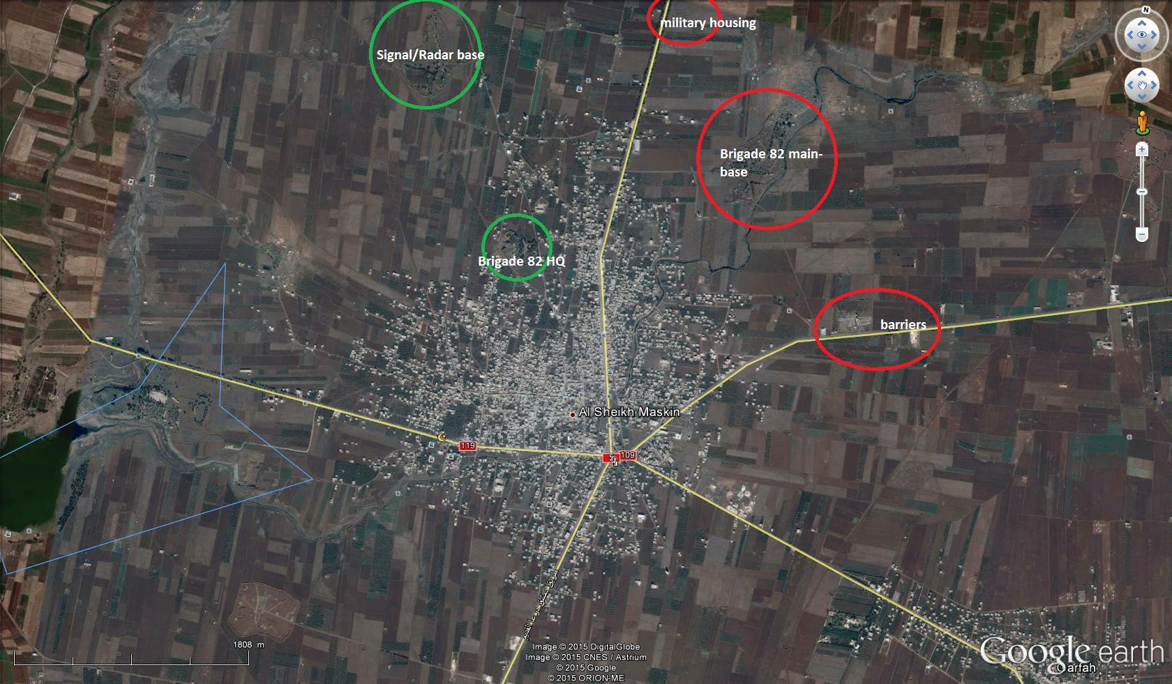
Brigade 82 in Sheiyh Miskin now belongs to opposition
Brigade 82 must be green now.88.224.195.133 (talk) 17:25, 25 January 2015 (UTC)
- The Nusra Front, several rebel and Islamic factions seize the Brigade 82: http://syriahr.com/en/2015/01/the-nusra-front-several-rebel-and-islamic-factions-seize-the-brigade-82/
- Syria rebels overtake strategic base in south http://www.dailymail.co.uk/wires/reuters/article-2925673/Syria-rebels-overtake-strategic-base-south.html
- Syria rebels overtake strategic base in southern Deraa province http://www.jpost.com/Breaking-News/Syria-rebels-overtake-strategic-base-in-southern-Deraa-province-388895
- Middle East Updates / Nusra Front overtakes strategic army base in southwest Syria http://www.haaretz.com/news/middle-east/middle-east-updates/1.638824
- Jihadist groups seize military base in southern Syria http://www.china.org.cn/china/Off_the_Wire/2015-01/25/content_34650893.htm 88.224.195.133 (talk) 17:30, 25 January 2015 (UTC)
Just pointing out: the rebels seized the Brigade 82 HQ inside the city of Sheikh Miskin. That HQ is not shown in our map, since it is inside the city. The base pointed out as green here is still regime held. — Preceding unsigned comment added by 177.41.251.231 (talk) 17:41, 25 January 2015 (UTC)
- According to pro opposition sources rebels captured only HQ Brigade 82 inside city and Army radar base (Brigade 82) which refers to the Brigade 82 here Archicivilians But main base of Brigade 82 still under control by army.here The base that considered as part of Brigade 82, located between NE-Sheikh Maskin and SW-Izzra', still under the Regime control.Archicivilians Hanibal911 (talk) 18:28, 25 January 2015 (UTC)
Neutral sources for Brigade 82 and Sheikh Maskin:
- http://english.alarabiya.net/en/News/middle-east/2015/01/25/Syria-rebels-overtake-strategic-base-in-south.html
- http://www.haaretz.com/news/middle-east/middle-east-updates/1.638824
- Neutral sources?! Lol this is too funny. ChrissCh94 (talk) 22:51, 25 January 2015 (UTC)
So it seems the entire Brigade 82 should go to green together with Al-Shayk Miskin. Only the Military Housing remain red, and maybe the BRigade itself contested?
- Sources not indicated that rebels was captured main base of brigade 82 but pro opposition sources clear indicated that rebels captured HQ Brigade 82 and Radar base (Brigade 82)here and here Btu pro opposition sources clear said that main base of Brigade 82 still under control by army.here Archicivilians Hanibal911 (talk) 18:52, 25 January 2015 (UTC)
- Pro-govt almasdar reports that SAA retreated from the base: http://www.almasdarnews.com/article/daraa-al-nusra-front-captures-brigade-82-base/
186.112.217.134 (talk) 04:47, 26 January 2015 (UTC)
- Al Masdar some times make mistake and it not said about main base Brigade 82 because Army radar base (Brigade 82) it is also base of Brigade 82. So as I said earlier we need more data. Because pro opposition sources clear said that main base of Brigade 82 still under control by army.here Archicivilians Also pro opposition only said that the Syrian regime lost the most powerful Air-Defense Bases in Southern Syria Brigade 38 in 2013 and Brigade 82 in 2015. But main base Brigade 82 still under control by Syrian troops Hanibal911 (talk) 08:39, 26 January 2015 (UTC)
- What our map shows relating to base 82 :
- 1) The HQ, just north of the town, captured according to several reports, is labeled "brigade 82". It is still red on our map.
- 2) The radar base part, also captured according to several reports, is labeled "army radar base (brigade 82)". It is now green.
- 3) The main part of the base, to the north-east, is labeled "air defense base". There is another another icon to the east, of a smaller part of the base, labeled the same. Some reports say that these are now contested, if not still regime held. They are still red on our map.
- 4) There are 2 icons labeled "military housing" for the base, to the north and the east. They are still red on our map. At least one map I've seen shows a third such housing, to the north of the main base.
- 5) Interesting that the almasdarnews article claims that Nusra captured the base, without mentioning any others. Considering that besides one early report from Nusra, all reports and video evidence comes from the various FSA groups involved. Typical of almasdarnews (and other pro-regime) reports. André437 (talk) 08:39, 26 January 2015 (UTC)
- André437 Pro opposition clear showed on map tha rebels captured HQ Brigade 82 inside city and Army radar base (Brigade 82) which refers to the Brigade 82 here and biased pro opposition source Archicivilians also clear said that rebels today took Brigade 82 HQ in Sheikh Maskin, while clashes still ongoing around the base between Sheikh Maskin & Izzra'here and also said that the base that considered as part of Brigade 82, located between NE-Sheikh Maskin and SW-Izzra' still under Regime controlhere Also here video where Rebels inside Brigade 82 HQ in thetown of Sheikh Maskin.here But main base brigade 82 this clear showed pro opposition map here Hanibal911 (talk) 08:53, 26 January 2015 (UTC)
- Basically that coincides with what I said. Note that the brigade 82 HQ, shown on our map, is now lime (as it should be) instead of red. Sheikh Maskin town is placed a little too much to the west relative to the other positions. Note that it is debatable whether the HQ is in the town, or just north of it (as I see it).
- If you look carefully, there is an icon labeled "air defense base" in the appropriate location relative to Izra. Since brigade 82 is THE air defense base in proximity, this must be the main part of the base. That coincides with the locations of the military housing as well.
- From the various unconfirmed reports, I wouldn't be surprised if the rest of base 82 falls quickly, and likely Izra also.
- BTW, since archicivilians frequently uses the phrase "unconfirmed reports", I wouldn't call him very biased in his reporting. I've yet to see that sort of qualification from almasdarnews. André437 (talk) 10:40, 27 January 2015 (UTC)
Masharah?
Why is the town of Masharah in Quneitra turned to contested? Last time there was any news, it was of rebels shelling Tell BRrizaq near the town. Can somebody provide sources or revert the contested status back to green?
- This village was marked as contested only based the pro-government source but this violates the rules of editing. So that I fixed this. So that this village can be noted as contested if this data can confirm a reliable or pro opposition sources. Hanibal911 (talk) 19:08, 25 January 2015 (UTC)
Al masdar is relaible. More than SOHR. That has been discussed many times.Paolowalter (talk) 20:44, 25 January 2015 (UTC)
Both SOHR and Al-Masdar are not reliable. Both can only be used for advances for the other side. — Preceding unsigned comment added by 177.41.251.231 (talk) 20:47, 25 January 2015 (UTC)
- Palowalter Al-Masdar is a pro-regime source we have disscus that.Lindi29 (talk) 21:59, 25 January 2015 (UTC)
- We have discussed, and concluded that it is a reliable source that is biased, like SOHR. XJ-0461 v2 (talk) 22:38, 25 January 2015 (UTC)
- No we haven't decided that at all. The status quo remains: SOHR is reliable, al-Masdar news is not.137.73.84.232 (talk) 02:21, 27 January 2015 (UTC)
- No it does not, that is why we had the discussion in the first place. No reason for the status quo to be maintained. XJ-0461 v2 (talk) 03:29, 27 January 2015 (UTC)
- No we haven't decided that at all. The status quo remains: SOHR is reliable, al-Masdar news is not.137.73.84.232 (talk) 02:21, 27 January 2015 (UTC)
- We have discussed, and concluded that it is a reliable source that is biased, like SOHR. XJ-0461 v2 (talk) 22:38, 25 January 2015 (UTC)
Shayk Maskin
Hello everybody,
I've been following the events in and around Shayk Maskin for the last two days. I have several questions:
1. Why is Shayk Maskin still contested? Brigade 82 was the last part of the town that was held by the SAA wasn't it? The fighting now seems to be around the Electric Grid Station checkpoint. 2. Does anybody have information about al-Dalli and Suhaliyah north of Shayk Maskin? Twitter sources posted videos and claims that both had fallen to the Southern Front? 3. Maybe add a green circle to the western side of Qarfa? Rebels are close by, that was the reason Rustom Ghazali burned down his own palace there in December 14. — Preceding unsigned comment added by 84.24.43.183 (talk) 16:34, 26 January 2015 (UTC)
This is a summary of events: http://eaworldview.com/2015/01/syria-daily-insurgents-celebrate-victories-across-country/
It seems that rebels have made another sweeping advance in Daraa, capturing the Engeneering Brigade in Suhayliyah and al-Dalli, and are currenty (according to twitter) fighting for Al-Furqan village. Some activists are even talking about fighting close to Izzra itself. We should keep an eye on that. — Preceding unsigned comment added by 84.24.43.183 (talk) 18:09, 26 January 2015 (UTC)
- It is a pro opposition source and we cant use this source to show success of rebels. But more the reliable source said that rebels captured most part city of Sheikh Miskeen. But not said that city now under control by rebels.The Daily Star Hanibal911 (talk) 19:12, 26 January 2015 (UTC)
Why are there so many edits north of Sheik Miskin, it's not possible to put them all there. What's about this Farun Storage base, does it even mention in some sources ? An under that, there also 2 checkpoints/bases which are covered with this edit. There's another one, third, you can see a fraction of it to the left. What's the point ? The map is overfilled DuckZz (talk) 20:55, 26 January 2015 (UTC)
I believe taking a good look there is important. Official FSA news said they captured Dilli, Burqa, Faqah and al-Suhayliyah and one Battalion 60 base. That can't be used for rebel advances here, but we should really look at the situation. — Preceding unsigned comment added by 177.41.251.231 (talk) 00:06, 27 January 2015 (UTC)
- Hanibal911 the IP has a good point and we have to take a good look on this beacause he provided pro-opp sources but not sources from agencies news but from videos,and i think videos are more reliable like the kurds who were the first that reported the capture of kobane and villages nearby,but first we have to wait and see what happens if there are more reports and videos in the upcoming days.Lindi29 (talk) 00:57, 27 January 2015 (UTC)
- If it is the rebels amateur video from YouTube we can not use it for display success of rebels. Hanibal911 (talk) 08:26, 27 January 2015 (UTC)
Semi-protected edit request on 27 January 2015
This edit request to Module:Syrian Civil War detailed map has been answered. Set the |answered= or |ans= parameter to no to reactivate your request. |
Change
"{ lat = "36.854", long = "38.379", mark = "Location dot black.svg", marksize = "6", label = "Qarah Halinj", link = "Qarah Halinj", label_size = "0", position = "top", },"
to
"{ lat = "36.854", long = "38.379", mark = "Dot_yellow_ff4.svg", marksize = "6", label = "Qarah Halinj", link = "Qarah Halinj", label_size = "0", position = "top", },"
Sources:
https://twitter.com/jackshahine/status/559837529709772801
https://twitter.com/ChuckPfarrer/status/559846335621656576
http://www.sasnewsagency.com/read/10221
Halinj village is YPG-held. 2601:0:B200:F7D9:6571:56B8:6EF9:5C27 (talk) 03:07, 27 January 2015 (UTC)
 Not done: please provide reliable sources that support the change you want to be made. Mlpearc (open channel) 03:32, 27 January 2015 (UTC)
Qarah Halinj
This village was marked as under control by Kurds only based data from a pro Kurdish source here but we cant use data from Kurdish sources to show success of Kurds. So if not have confirmation this data from reliable source we need again mark this village under control by ISIS. Let's not break the rules of editing. Hanibal911 (talk) 10:15, 27 January 2015 (UTC)
- Sure, but if you have photographic or video evidences (this is the case) I think that it is not forbidden to use non neutral sources. The pictures shown have been shot exactly here: http://wikimapia.org/#lang=en&lat=36.855656&lon=38.379579&z=17&m=bs , you can easily recognize the water tower of Helinj. --8fra0 (talk) 10:51, 27 January 2015 (UTC)
- 8fra0 We can only use the video from neutral sources such as World news agencies but not amateur video. And this photos which provide the Kurdish activist from the village does not confirm that the village under the control of the Kurds in fact the same photos can be done from any city or village which is under the control of ISIS. On one photo we just see that soldier is near the village here and on other photo we see several cars which enter in the village here but how can we be sure that this Kurdish troops or that village under their control. We need more confirmations from a neutral source. Hanibal911 (talk) 11:21, 27 January 2015 (UTC)
- For sure a single picture can not guarantee that a whole town or city is in full control by anyone, but (imho) a picture showing a YPG flag on the highest building of a village of 20 buildings, with a journalist roaming around, is enough to state that that village is in YPG control. However we have also SOHR confirmation: http://syriahr.com/en/2015/01/ypg-takes-control-on-helnej-village-southeast-of-kobane/ --8fra0 (talk) 11:36, 27 January 2015 (UTC)
- 8fra0 We can only use the video from neutral sources such as World news agencies but not amateur video. And this photos which provide the Kurdish activist from the village does not confirm that the village under the control of the Kurds in fact the same photos can be done from any city or village which is under the control of ISIS. On one photo we just see that soldier is near the village here and on other photo we see several cars which enter in the village here but how can we be sure that this Kurdish troops or that village under their control. We need more confirmations from a neutral source. Hanibal911 (talk) 11:21, 27 January 2015 (UTC)
- 8fra0 So we received official confirmation so that just was need wait. Good job! Hanibal911 (talk) 11:41, 27 January 2015 (UTC)
Broken links
Listen to friends if you want to use to edit a link to Arabic source is better to provide a link to it on the talk page. Because when you when you edit put a link to the source your link often displayed as broken and we can not verify data wgich you have provided as a source which confirm your editings. And here examples of this:here or here Because if we cant verify the accuracy of the information which was provide as a source. And this editing will be considered is not justified. I hope for your understanding. Regrds! Hanibal911 (talk) 10:30, 27 January 2015 (UTC)
Villages around Kobane
I couldn't find any reliable source or visual evidence (pictures, videos, and so on) confirming the YPG control of the following villages aorund Kobane: Kurabi and Jiqur (western front); Kulmah (southern front); Shiran and Mazraat Dawud (eastern front). According to this source those villages seem still in IS control, or at least disputed: http://www.agathocledesyracuse.com/wp-content/uploads/2015/01/Kobane-27-Jan-2015-by-@deSyracuse.png --8fra0 (talk) 14:45, 27 January 2015 (UTC)
Agree but then again nobody can provide us with sources that ISIS controll all of the villages in northern aleppo and hasakah some of the villages that are shown as isis held in many place have probably been recaptured 10 times by rebels/kurds/al nussra front/saa Creepz
- I have found this source (Journalist "embedded" with YPG in Kobane) stating the various frontlines around Kobane. https://twitter.com/jackshahine/status/560033784822001664 I think that I can use this source to edit to IS held the villages which are out these frontlines. --8fra0 (talk) 15:36, 27 January 2015 (UTC)
- It is pro Kurdish source and according to the rules of editing we cant use it for display sucess of Kurdish forces. Hanibal911 (talk) 22:44, 27 January 2015 (UTC)
- I have to agree with Hanibal911 beacause the YPG after a long devestating battle just recaptured Kobane,and i dont think they have just make an offenisve like this beacause they have still to clear the areas from mines.And i think this town should go contested except Kulmah which is Isis held.Lindi29 (talk) 23:04, 27 January 2015 (UTC)
Jabhat al akrad in aleppo countryside?
Hello i have been reading about jabhat al akrad lately and i watched tons of videos from them most of the videos are from clashes in northern aleppo but the map only shows the villages rebel held are there no jabhat al akrad in northern aleppo? Im also following people that are close to al akrad and they claim to be activly fighting in northern aleppo against isis together with Dawn of freedom and islamic battalions. Thus i think yellow dots together with green dots should be placed just like in kobane city — Preceding unsigned comment added by Creepz55 (talk • contribs) 14:54, 27 January 2015 (UTC)
We marked 1 vilage under joint control because there was a source showing that, everything else is unclear. DuckZz (talk) 15:14, 27 January 2015 (UTC)
SAA DEYR EZ ZOR
reports of saa advancing in deyr ez zor any truth in this? — Preceding unsigned comment added by Creepz55 (talk • contribs) 15:02, 27 January 2015 (UTC)
Jabat Akrad presence in Mare aleppo
First soure is map made by thomas(arabthomnes) 17 january 2015 https://pietervanostaeyen.files.wordpress.com/2015/01/2000px-syria2.png
second source is known ypg source. https://twitter.com/ColdKurd/status/506045034958159872 31 august 2014
Third source is https://twitter.com/sergermed/status/525539988495400960 a guy known to be close to al akrad front — Preceding unsigned comment added by Creepz55 (talk • contribs) 16:30, 27 January 2015 (UTC)
Last 2 sources are a bit old. Try to find something from this year because the frontline has changed alot so the groups too. DuckZz (talk) 21:57, 27 January 2015 (UTC)
Trusted Akrad commander source said that rebels captured Hawr Al Nahr. DuckZz (talk) 22:05, 27 January 2015 (UTC)
Azaz
City of Azaz need mark under jointly controlled by moderate rebels and Al Nusra because pro opposition source clear showed that this city under their joint control.here Hanibal911 (talk) 20:02, 27 January 2015 (UTC)
- Agree.Lindi29 (talk) 20:34, 27 January 2015 (UTC)
Don't start it. If we start to do this, the map will be ruined in few weeks. Al Nusra has presence in almost every town where rebels are but in minority numbers. We already agreed to mark their presence only in Idlib province because everywhere else they have a small number of fighters. We can only mark a place under their control if a source, for example SOHR, names only their group inside an article, for example Wadi Daif etc. Therefore joint control edits are bad ideas. There were already enough sources from Jan channels saying that their soldiers are active on Alepo frontlines and mainly keeping checkpoints around towns/villages. I belive a week ago their checkpoint was atacked with an IED. DuckZz (talk) 21:49, 27 January 2015 (UTC)
- DuckZz Well if you mentioned Idlib province this pro opposition source also showed that towns of Taftanaz and Sarmin jointly controlled of Al Nursra and Islamic Front.here Hanibal911 (talk) 22:16, 27 January 2015 (UTC)
Arabthomes map is biased and full of mistakes, we already have deSyracuse, his maps are more reliable. . . . . . . . . . I meant to say full control, not joint control. All places that might me under full JAN control are already marked in Idlib province. We all know that there's probably a significant amount of rebel groups (Islamic front) inside Marat Numan but sources are still showing that JAN has the upper hand. Joint control is a pretty bad idea, at least for JAN-Rebel presence. On the other hand Kurd-Rebel is more logical since they don't fight each other. DuckZz (talk) 00:24, 28 January 2015 (UTC)
- I don't have sources handy, but there were reports that Azaz was under full control of Northern Storm brigades, even though a small number of Nusra were present. Northern Storm is based in Azaz, and part of the new Shami alliance formed of one large IF group (of which Northern Storm was part), and 4 large moderate groups, as well as many smaller groups.
- My point here is that we shouldn't jump to the conclusion that Nusra has any control in a location just because they have a presence, nor that they are in total control just because they have some control. That might apply to small villages, but unlikely to larger towns.
- Note that Nusra only ousted the SRF because they had a number of temporary allies. (And the SRF didn't plan protection against such an attack.) That doesn't leave Nusra in full control. We shouldn't jump to conclusions. We aren't regime propagandists, who like to claim jihadists under every rock.
- As well, an unannotated map is not a good basis for control by itself, although it may indicate information to be verified by other sources. Additionally, some maps may only be indicating presence, and not control. There is surely a pro-rebel presence in Latakia city (from various incidents), but we're not about to show it on our map. André437 (talk) 05:58, 30 January 2015 (UTC)
Menas, Alblour, jolbeek + Qeremezre liberated
Confirmed source within YPG.
https://twitter.com/ColdKurd/status/560174122958086144 — Preceding unsigned comment added by 213.100.194.177 (talk) 21:53, 27 January 2015 (UTC)
Qeremezre in the southeast of Kobani is also in YPG's control Confirmed by a reliable pro YPG source with pictures https://twitter.com/Avashin/status/560799992362053632 https://twitter.com/Avashin/status/560800122016395265 --88.72.87.121 (talk) 14:11, 29 January 2015 (UTC)
Tabarat al Khashir
pro Al Nusra source confirmed that Tabarat al Khashir under control by army.here Hanibal911 (talk) 22:01, 27 January 2015 (UTC)
- Hanibal911 Elijah Magnier said the same so this al-nusra front is mb an imposter account.Beacause JAN WILL never make such tweets for SAA.Lindi29 (talk) 22:58, 27 January 2015 (UTC)
- Lindi29This official source of Al Nusra. Hanibal911 (talk) 06:42, 28 January 2015 (UTC)
Semi-protected edit request on 27 January 2015
This edit request to Module:Syrian Civil War detailed map has been answered. Set the |answered= or |ans= parameter to no to reactivate your request. |
Change
{ lat = "36.875", long = "38.302", mark = "Location dot black.svg", marksize = "6", label = "Minas", link = "Minas, Syria", label_size = "0", position = "top", },
to
{ lat = "36.875", long = "38.302", mark = "Dot_yellow_ff4.svg", marksize = "6", label = "Minas", link = "Minas, Syria", label_size = "0", position = "top", },
and
{ lat = "36.898", long = "38.268", mark = "Location dot black.svg", marksize = "6", label = "Kurabi", link = "Kurabi", label_size = "0", positon = "top", },
to
{ lat = "36.898", long = "38.268", mark = "Dot_yellow_ff4.svg", marksize = "6", label = "Kurabi", link = "Kurabi", label_size = "0", positon = "top", },
and
{ lat = "36.885", long = "38.291", mark = "Location dot black.svg", marksize = "6", label = "Mazra‘at Saghir", link = "Mazra‘at Saghir", label_size = "0", position = "top" },
to
{ lat = "36.885", long = "38.291", mark = "Dot_yellow_ff4.svg", marksize = "6", label = "Mazra‘at Saghir", link = "Mazra‘at Saghir", label_size = "0", position = "top" },
Sources: http://www.agathocledesyracuse.com/wp-content/uploads/2015/01/Kobane-27-Jan-2015-by-@deSyracuse.png https://twitter.com/ChuckPfarrer/status/560037597616295936 https://twitter.com/ChuckPfarrer/status/560146708525748225
These villages have been taken by the YPG. 2601:0:B200:F7D9:D0EA:D699:DC28:4E9C (talk) 22:42, 27 January 2015 (UTC)
Deir El Zor
Greetings. So this pro-gov source here [6] and this neutral source here [7] [8] both show Jafra is still ISIS-held and/or contested while Mari'iyah is gov-held. ChrissCh94 (talk) 02:26, 28 January 2015 (UTC)
- EJM elaborated on the matter, saying that only east Jafra is ISIS controlled here: https://twitter.com/EjmAlrai/status/560125702196842496. Perhaps we should extend the black color farther into the town. XJ-0461 v2 (talk) 02:36, 28 January 2015 (UTC)
- Yes I did read that out and you are right, maybe push the ISIS controlled territory a bit more to the west just so it becomes clear that they control the eastern half. Or just make it plain contested to avoid confusion. Either way a clarification should be made. ChrissCh94 (talk) 09:22, 28 January 2015 (UTC)
- I agree with ChrissCh94.Beacause Isis is near the airport and there is clashes between the 2 parties.And we should add Isis presence near the airporthere.Lindi29 (talk) 17:43, 28 January 2015 (UTC)
Al Hamidiyah
Pro rebel source said that clashes inside Hamidiyah btw JaN and Assad here. Hamidiyah go to contested? (217.99.157.220 (talk) 20:36, 28 January 2015 (UTC))
- If its markito talking, then yes. XJ-0461 v2 (talk) 22:08, 28 January 2015 (UTC)
- Yeah, you are right, markito showed army progress (217.99.157.220 (talk) 23:52, 28 January 2015 (UTC))
Kobanî joint control
These villages outside Kobanî are under control of the YPG.
http://syriahr.com/en/2015/01/advances-for-ypg-and-rebel-battalions-southwest-of-kobane/
This source was used to justify an edit of these villages. However, Syrian Observatory of Human Rights is a well-known pro-rebel source, and under the editing guidelines should not be allowed to show rebel gains. Therefore, these villages should be marked under Kurdish control. 2601:0:B200:F7D9:CC74:2374:3F11:4F92 (talk) 21:27, 28 January 2015 (UTC)
The source is used to show everyone’s gains, you don't have to spin the topic and use it for your own purpose. Kataib Shamal group published pictures showing their fighters inside those vilages here and here2. DuckZz (talk) 22:00, 28 January 2015 (UTC)
I'm trying to say that the Kurds control the village. The FSA are only acting as a supporting force, and they don't have full or even partial control of the villages. There is no joint control agreement between FSA and YPG. I think it is a misrepresentation to show joint rebel control of these villages. I would be perfectly happy with a green rebel presence icon, as I feel it would more accurately represent the situation on the ground. 2601:0:B200:F7D9:CC74:2374:3F11:4F92 (talk) 22:40, 28 January 2015 (UTC)
Also, these YPG gains need to be added.
http://syriahr.com/en/2015/01/advances-for-ypg-and-rebel-battalions-southwest-of-kobane/ 2601:0:B200:F7D9:CC74:2374:3F11:4F92 (talk) 02:56, 29 January 2015 (UTC)
I'm sorry but we edit the map according to sources we have and not according to those we don't have, logically. There are at least 2 rebel groups (Northern Sun, Liwa Raqqa) present in Kobani area so we can assume they have a significant amount of fighters there, of course YPG is the main leading role and that's why we mark it only as partial rebel control and not full. Also if you're interested, they have their facebook channels with dozens of pictures from these villages. DuckZz (talk) 11:01, 29 January 2015 (UTC)
JA source claims JA controlls these villages
https://twitter.com/sergermed/status/560578422511259648?lang=sv
https://twitter.com/sergermed/status/560576534407565312
some of these villages are marked however Qazal,Dalha,Kara köpru,Tatmarash and Maryamin aren't marked. — Preceding unsigned comment added by Creepz55 (talk • contribs) 07:55, 29 January 2015 (UTC)
- It is pro Kurdish source which cant be used for displayed success of Kurds. Hanibal911 (talk) 10:05, 29 January 2015 (UTC)
It's a trusted commander source. We can only use it in this case, for example : there are 3 villages, 1-2-3, the first one is marked as Kurd control, the last two as ISIS. If this source reports that Kurds gained the village "3" located far more to the east, then we can change the village "2" under Kurd control, but not "3" as we need more sources. Understood ? DuckZz (talk) 11:16, 29 January 2015 (UTC)
Well the guy makes sense because if you look at the map these three villages are the three villages al akrad might have ran to after being expelled from Dodiyan also there is confirmed al akrad presence in qara mazraah this explains from where al akrad are getting their support to attack qara mazraah which is far north dodiyan will probably be recaptured.
https://twitter.com/ShamiWitness/status/501400501804859392?lang=sv — Preceding unsigned comment added by Creepz55 (talk • contribs) 11:33, 29 January 2015 (UTC)
FSA villages
source on balazah, banan al has and abu abdah being fsa held and not regime. — Preceding unsigned comment added by Creepz55 (talk • contribs) 08:07, 29 January 2015 (UTC)
111th Regiment under Nusra control
SOHR reported clashes between Hazm and Nusra which ended in a Nusra victory and Nusra control over the 111th Regiment in Aleppo [9] with casualties on both sides as well as POW's ChrissCh94 (talk) 11:49, 29 January 2015 (UTC)
 Done This once again confirms that the clashes between Al Nusra and moderate rebels not only in Idlib province. Hanibal911 (talk) 12:58, 29 January 2015 (UTC)
Areas north of Shayk Miskin
There have been no neutral sources concerning the areas north of Shayk Maskin (mainly al-Suhayliyah, al-Dalli, Barqah and Faq'ah). Twitter sources and pro-rebel media claimed those towns had been taken in the Brigade 82 offensive. This seems to be the case as you look at images and video evidence. However, we have no sources. So what should we do? Because it seems hard that those towns are still in SAA hands as rebels are shelling Izra itself. It would expose their flank near Brigade 82 to SAA attacks. — Preceding unsigned comment added by 84.31.204.195 (talk) 13:22, 29 January 2015 (UTC)
- We are not interested read your imaginations! Also we can not use the data from a pro-opposition sources for display of sucess the rebels. Hanibal911 (talk) 14:58, 29 January 2015 (UTC)
And "we" are not interested in your ongoing data-war. You just used a pro-opposition TWITTER SOURCE to show SAA advances, but refuse to use the only availlable sources to even think about the position of those villages. Shows the true colors of this map, doesn't it :) — Preceding unsigned comment added by 84.31.204.195 (talk) 15:45, 29 January 2015 (UTC)
You keep showing pro op sources and then ask the question (what should WE do?) well the answer is wait for a neutral source to confirm .Then post it and change the map .Pyphon (talk) 16:28, 29 January 2015 (UTC)pyphon
- We use progovernment sources for display success of rebels and pro opposition sources for display success of army. Hanibal911 (talk) 16:39, 29 January 2015 (UTC)
- Because opposition sources distort the situation in favor of the rebels and pro-government in favor of the Army. Hanibal911 (talk) 16:48, 29 January 2015 (UTC)
Why is Sheikh Maskin green? See article here: http://english.al-akhbar.com/content/open-confrontation-southern-syria-‘moscow-forum’-sputters-along According to these updates from Al Akhbar (which is pro-HEZ obviously) but which also has a decent track record of accurate information on battles in syria. The new article states that the battle for al-Sheikh Maskin continues with the government bringing in reinforcements from Izra. This occurred after combined FSA & JAN forces took over the brigade 82 post. It says that fighting is currently taking place in towns of Atman, al-Fiqi, al-Dali, and al-Sahiliyah. It also says JAN & SAA clashing at outskirts of Zabadani, and that JAN has taken losses in towns of Yaboos and Kafir Yaboos (north of Beirut-Damascus road) so fighting must be occuring in those areas. Also says fighting ongoing in Ashrafieh neighborhood of Aleppo city. — Preceding unsigned comment added by 169.231.151.89 (talk) 20:33, 29 January 2015 (UTC) I suggest turn Sheikh Maskin to contested , as well as the two red government held towns to its north (al-Suhiliyah and Dilli (which I think is also al-Dali in the above article). I'm not sure where the other towns that Al Akhbar names are located. A big battle is ongoing in that area above Daraa- and it could be decisive for the south if rebels move on to Izra or if government reinforcements are able to stop them and counter. — Preceding unsigned comment added by 169.231.151.89 (talk) 20:51, 29 January 2015 (UTC)
- Al Akhbar not pro Hezbolah it is a reliable source. And Al Akhbar not said that clashes in the towns of Atman, al-Fiqi, al-Dali, and al-Sahiliyah source just said that rebels advance toward of the Atman, al-Fiqi, al-Dali, and al-Sahiliyah, concurrently in an attempt to “distract” the Syrian troops from the battles in al-Sheikh Maskin, which the insurgents seek to capture in order to control the Damascus-Daraa road.Al Akhbar Hanibal911 (talk) 22:11, 29 January 2015 (UTC)
Every pro-opposition source is saying that rebels do not control the villages north of Sheik Miskin but are trying to capture them, specially the 60th batalion. On this FSA channel, you can see the latest videos, in what they are trying to capture Al Suhayliah but with no succes. DuckZz (talk) 22:30, 29 January 2015 (UTC)
Maybe this is helping? http://www.almasdarnews.com/article/rebel-offensive-intensifies-daraa-syrian-army-recaptures-faroun-storage-facility/ This article tells that rebels pushed SAA out of al-suhayliyeh, but retook the Faroun storage facility. It's my first post here, so sorry if I make mistakes, but Almasdarnews is a pro-regime source so we can use it to depict rebel gains? Raspoetin89 (talk) 07:39, 30 January 2015 (UTC)Raspoetin89
I found a SOHR statement http://syriahr.com/en/2015/01/the-government-warplanes-and-helicopters-attack-various-areas-in-idlib-and-daraa/ saying: 'The helicopters dropped barrel bombs on areas in the towns of Barqa' Does that mean we have to change Barqa to contested? Raspoetin89Raspoetin89 (talk) 07:54, 30 January 2015 (UTC)
So that would mean Al-Suhayliyah to contested, Barqah to rebel held. What about Dilli/al-Dalli? It seems fighting is ongoing everywhere there and there are contradicting reports. Contested? — Preceding unsigned comment added by 84.24.43.183 (talk) 09:27, 30 January 2015 (UTC)
- Nice try but SOHR not said that Al-Suhayliyah contested or Barqah under control by rebels. Hanibal911 (talk) 14:47, 30 January 2015 (UTC)
- According to Al-Masdar Al-Suhayliyah is captured by rebels and Barqah is contested so we need to change them.Hanibal911 do you agree or do you have any source ? Lindi29 (talk) 16:44, 30 January 2015 (UTC)
- Lindi29 Source Al Masdar reported that Al Nusra and FSA just captured farms near Al-Suhayliyyeh. Source clear said that Al Nusra captured farms outside of Al-Suhayliyyeh. Also source said that north of Al-Suhayliyyeh, militants from the Al-Nusra Front and the FSA carried out a number of attacks in the villages of Dilli and Burqah the rebels were able to make initial gains but however, the 5th Division was able to forestall their progress and regain their lost positions. Al Masdar Also source Al Akhbar source said that rebels advance toward of the Atman, al-Fiqi, al-Dali, and al-Sahiliyah, concurrently in an attempt to “distract” the Syrian troops from the battles in al-Sheikh Maskin, which the insurgents seek to capture in order to control the Damascus-Daraa road.Al Akhbar But not said that rebels captured those villages. Hanibal911 (talk) 16:57, 30 January 2015 (UTC)
- According to Al-Masdar Al-Suhayliyah is captured by rebels and Barqah is contested so we need to change them.Hanibal911 do you agree or do you have any source ? Lindi29 (talk) 16:44, 30 January 2015 (UTC)
Hanibal911. is correct rebels try to advance in the area but no take towns yet .Wait for more sources fighting is ongoing .Pyphon (talk) 17:09, 30 January 2015 (UTC)pyphon
Khattab (Homs)
Village Khattab east of Homs city on the frontline between SAA and ISIS is not marked on the map. According to Peto Lucem village has been recaptured by SAA, tweet here and map here. Village should be put out and marked red, or at least put out and marked contested. Rhocagil (talk) 22:57, 29 January 2015 (UTC)
- There's SOHR confirming the latest gov. advance in Khattab, E-Homs: [10] ChrissCh94 (talk) 09:26, 30 January 2015 (UTC)
- They also captured Mushayrifah per gov-source [11] so at least add those 2 towns as contested or gov-held. ChrissCh94 (talk) 09:44, 31 January 2015 (UTC)
YPG advance in Kobane countryside
SOHR HERE confirms that YPG is advancing a lot around Kobane without specifying the names of the villages in YPG hands. Thomas Van Linge in his twitter account lists the villages taken by YPG, can this source be considered reliable? These are the village in YPG hands: https://twitter.com/arabthomness/status/560880083217711104 https://twitter.com/arabthomness/status/560873399053205505 https://twitter.com/arabthomness/status/560838351415431168
Here Jack Shahine shows pictures of another village in YPG hands: https://twitter.com/jackshahine/status/560819051535269889 — Preceding unsigned comment added by 8fra0 (talk • contribs) 12:11, 30 January 2015 (UTC)
SOHR YPG advances and take control on 14 new villages around Kobane. Rhocagil (talk) 14:13, 30 January 2015 (UTC)
YPG claims to have controlled the Communications Facility south of Kobane with visual proof here:
https://pbs.twimg.com/media/B8lfMukIAAAD7HC.jpg
https://pbs.twimg.com/media/B8lflneIQAAjkpz.jpg:large
186.119.54.226 (talk) 14:56, 30 January 2015 (UTC)
- It is here: http://wikimapia.org/#lang=it&lat=36.894097&lon=38.254910&z=16&m=b . It confirms the claims that at least Zorava and Kurabi village are in YPG hands. — Preceding unsigned comment added by 8fra0 (talk • contribs) 16:35, 30 January 2015 (UTC)
Yes it proves it, I wouldn´t see why not.Rhocagil (talk) 17:02, 30 January 2015 (UTC)
Jack Shahine (journalist based in Kobane) claims https://twitter.com/jackshahine/status/561308131331162112 that YPG is in control of Siftek, Moman e Boban that is located here: http://wikimapia.org/#lang=en&lat=36.896371&lon=38.195515&z=13&m=b Let's wait some additional sources. — Preceding unsigned comment added by 8fra0 (talk • contribs) 23:57, 30 January 2015 (UTC)
Daraa
The official Syrian Revolution Facebook page citing what the regime still holds in the province of Daraa': [12]
- Izraa
- Mhajjah
- Al Sanamayn
- Al Dali
- Al Faki (AL Fukay')
- Khirbit Ghazeleh
- Brigade 15
- Brigade 52
- Busra al Sham which is contested
- Qarfa
- Namer
- Nassib Crossing
- Brigade 34 in Al Lajat
- Jbab
- Ghabagheb
ChrissCh94 (talk) 17:24, 30 January 2015 (UTC)
Kafrlata - Idlib
I think it is rebel held since it explains how the attacks in Ariha were orchestrated. Here a pro-regime page describing every detail of the attack on Ariha said the rebels were defeated and retreated back to Kafrlata [13]. And we have numerous accounts of shelling on Kafrlata so I really doubt it is contested. Can my fellow editors provide me with sources saying otherwise? ChrissCh94 (talk) 17:29, 30 January 2015 (UTC)
There is a misunderstanding here. Rebels did not attack Ariha town. Their main objective (announced on IF channels) was to capture the mountain part that overlooks Ariha (in that case Al Fanar checkpoint too). Groups in this offensive :
- Mainly Islamic Front (Suqur Sham, Faylaq Sham) supported by
- FSA (Liwa Haq, 13th Division) and
- Al Nusra (even thought i haven't seen them)
- Here SOHR source says that rebels advanced on the mountain on al-Baradat building complex, which includes Al Fanar checkpoint. They also said that rebels destroyed a regime vehicle in Mastomah, and here is the proof FSA 13th division destroying shilka in Mastomah.
- On this source SOHR2 also said that rebels advanced on the mountain and detonated a tunel bomb in Al Fanar complex. Here is the proof, Islamic Front detonating the bomb.
- Now some pro-opposition sources. Islamic front shooting mortars from Kafr Lata here and here2 .. Suqur Sham (IF) commander giving moral speech in Kafr Lata before the offensive.
−Now I'm 100% sure that rebels took Al Fanar because it's located right in the start of the mountain, and if SOHR says that rebels advances there, it means it's not possible to advance while avoiding this checkpoint.
- This video shows rebels overlooking the town of Ariha.
- This video shows Al Fanar checkpoint and FSA (Liwa Haqq) members just passing by it. Kafr Lata should definately be changed, I'm not sure for Al Fanar but i want other opinions. DuckZz (talk) 23:11, 30 January 2015 (UTC)
- Yes, so confident, yet SOHR did not trumpet this "glorious" victory...interesting. The rebel offensive has failed [again] http://www.almasdarnews.com/article/idlib-syrian-army-reaffirms-full-control-areeha/ XJ-0461 v2 (talk) 00:40, 31 January 2015 (UTC)
If rebels gained areas around the town, not even trying to attack Ariha, not even in plans. What is the best thing a pro-Government editor (2 times banned user from twitter) can write ? "SAA, NDF recaptured Ariha" haha facepalm really...DuckZz (talk) 00:46, 31 January 2015 (UTC)
Congrats, the SAA/NDF advanced in the area they already controlled. Al-Masdar so reliable, haha. The rebels never attacked Ariha, and now they retake Ariha. Next thing we will see is SAA retaking Homs or Qusayr, lol, they are so desesperate for wins they make-up advances in towns they hold already. — Preceding unsigned comment added by 200.219.152.90 (talk) 01:59, 31 January 2015 (UTC)
"haha facepalm really" Is this supposed to be a coherent sentence, because it is not. Also, the article referred to the Ariha area [locations such as Jabal al arba'een] being retaken, not the town itself [you would have known that if you read more than just the title]. Also, the fact that you are tracking the editor is just sort of weird. XJ-0461 v2 (talk) 02:57, 31 January 2015 (UTC)
- I gotta say DuckZz you are becoming way too biased. To be fair, except for the Southern Front, the rebels are indeed losing the war and infighting has triumphed among them. In 2013 they controlled more than half the country while now they only control rural Aleppo and Daraa. Sadly the war is headed towards a bloody stalemate where every party will make gains and consolidate them in areas of strength while losing the less important ones. Not to forget the rise of the jihadis. ChrissCh94 (talk) 09:12, 31 January 2015 (UTC)
CnrissCh94 .I agree Kafrlata is rebel controlled .Pyphon (talk) 12:35, 31 January 2015 (UTC)pyphon
ChrissCh94 I don't understand why you think like that. Rebels will lose that's for sure, but it'll take a while. I support the Syrian army (SAA) against rebels but i also support FSA rebels against NDF army, nobody can really hate me because of this. DuckZz (talk) 16:32, 31 January 2015 (UTC)
- It's just you oppose everything regime related. Everyone is entitled to an opinion but it must not interfere with our work. Nobody here hates you! Cheers mate. ChrissCh94 (talk) 18:05, 31 January 2015 (UTC)
the rebel advance in Southern Syria will define the conclusion of the war.Alhanuty (talk) 20:19, 31 January 2015 (UTC)
- What do you mean? XJ-0461 v2 (talk) 20:55, 31 January 2015 (UTC)
- Correction: The outcome of the battle of Aleppo will define the outcome of the war. Hint 2012: Rebels were winning in Aleppo and in all of Syria while in 2014: rebels are losing in Aleppo and in all of Syria. ChrissCh94 (talk) 23:30, 1 February 2015 (UTC)
Northern Homs
This area has always been tricky but after extensive research in pro-gov and pro-opp coordination committees I found out that:
- Hawsh Haju is rebel held via pro-gov source [14] and [15] along with Al Saan and Ain Hussein
- Pro-opp source reporting shelling on Hawsh Haju by gov-forces: [16]
So please change Hawsh Haju to green and add Ain Hussein and Al Saan also as rebel-held ChrissCh94 (talk) 09:43, 31 January 2015 (UTC)
- While in Eastern Homs it seems gov-forces have bee advancing and have captured Khattab and Mushayrifah via pro-gov [17] [18] and pro-opp [19] sources. So I suggest adding those 2 towns, Khattab as gov-held and Mushayrifah as contested. ChrissCh94 (talk) 09:48, 31 January 2015 (UTC)
- Also pro-government source said that the village of Mushayrifah ash Shamaliyah was captured from Islamic State so for now i noted this village as contested between Syrian troops and ISIS.here Hanibal911 (talk) 11:38, 31 January 2015 (UTC)
- Done According to data from pro government source and SOHR I noted Ayn Husayn, Hawsh Haju under control by moderate rebels and Khattab as gov-held but also I noted Mushayrifah ash Shamaliyah as contested. Hanibal911 (talk) 12:14, 31 January 2015 (UTC)
- Mushayrifah is now gov-held via SOHR [20]. So the SAA now captured Khattab and Mushayrifah in E-Homs ChrissCh94 (talk) 12:47, 31 January 2015 (UTC)
Peto Lucem General Map 30/1/2015
Here is https://pbs.twimg.com/media/B8n1Y6vCAAAh42A.jpg:large Peto Lucem Maps are very 99,99% correct most times
- It's Al-Masdar Map.here.Nice try,but Al-Masdar and Peto Lucem are pro-regime sources and we cant use them.Lindi29 (talk) 14:25, 31 January 2015 (UTC)
True. Both Al-Masdar and SOHR are unreliable in my opinion. Only use Al-Masdar to rebel advances, and SOHR for regime advances.
- What are you talking about Lindi? PetoLucem and Masdar have nothing to do with each other. Leith Fadel, the person behind al-Masdar uses his map, but they're are not the same person. Peto Lucem maps together with DeSyracuse's map have been some of the most precise maps during this conflict. While I agree that PetoLucem is a bit pro regime and DeSyracuse is a bit pro rebel.
- PetoLucem maps are NOT from al-Masdar, he (leith Fadel) simply uses the same maps Peto publishes on Twitter. Stop spreading lies. Masdar is fairly pro regime but the maps he uses are made by PetoLucem, not himself.MesmerMe (talk) 15:45, 31 January 2015 (UTC)
As far as I can tell, this map is fairly consistent with the one we have here. Only major difference is in Deir-Ez-Zor, where Peto has given the southern half to the SAA, whereas we have it as under ISIS control. That part of the governate is fairly empty anyway [only things we have listed in it as Shulah and Kabajeb], so the discrepancy is of no consequence. XJ-0461 v2 (talk) 19:36, 31 January 2015 (UTC)
XJ-0461 v2 .I agree Peto Lucem maps are always like ours and Lindi29 what do you mean (nice try )nobody was asking to change our map in line with his .Pyphon (talk) 19:52, 31 January 2015 (UTC)pyphon
The map is just very correct it showing the reality in the ground, Peto's Maps are always right.
Lucem always exagerates regime held territory. Aleppo specially, they had the Owaija District under SAA control for example. Now the rebels recaptured Breij area, and not a SINGLE source reported the rebels to have recaptured the Owaija District, but it is obvious they had to be there in other to reach Breij.
- Not really. And they did not recapture the Breij area. What source said that? XJ-0461 v2 (talk) 17:58, 1 February 2015 (UTC)
Zabadani & rest
According to IvanSidorenko and his pro-government sources here2, the SAA (and company) are aiming to capture Zabadani (already contested), Madaya, Serghaya and Yabous. What others think ? DuckZz (talk) 16:46, 1 February 2015 (UTC)
- That is interesting. Madaya and Serghaya were confirmed to be SAA held by Al-Monitor a long time ago. I am not aware of any rebel counter offensives in the area [which would place them back in rebel hands since then]. We really should not change anything with Zabadani since it is already contested and SOHR confirms SAA checkpoints in the town. As for Yabous, I have no news on that. I would say for now, green rings on all the towns you mentioned, and if you can find a corroborating source, we can take further action. XJ-0461 v2 (talk) 18:01, 1 February 2015 (UTC)
deSyracuse map shows Serghaya as contested. The map is 20 days old so maybe rebels do have control of those towns but now facing clashes with SAA & Hezbolah. I belive that IvanSidorenko is a bit pro-government oriented and not biased. Maybe Madaya should go contested since it's right next to Zabadani and SOHR reported barel bomb attacks on it's western outskirts DuckZz (talk) 18:25, 1 February 2015 (UTC)
- DuckZzPro opposition source showed that area wher located Madaya, Serghaya under control by army.here Also Ivan Sidorenko it is not pro government source and also deSyracuse map it is pro opposition source which we cant use to display success by rebels. Also previously biased a pro-opposition source clear showed that Serghaya under control by army.here Hanibal911 (talk) 19:25, 1 February 2015 (UTC)
- Also earlier some reliable sources reported that Serghaya under control by army. This issue has already been discussed previously. Hanibal911 (talk) 19:34, 1 February 2015 (UTC)
- We did agree earlier that Madaya was contested.. Serghaya is under local NDF control. ChrissCh94 (talk) 23:10, 1 February 2015 (UTC)
- Pro opposition source showed that area wher located Kafr Yabous under control by Syrian troops and Hezbollah.here Hanibal911 (talk) 09:02, 2 February 2015 (UTC)
- We did agree earlier that Madaya was contested.. Serghaya is under local NDF control. ChrissCh94 (talk) 23:10, 1 February 2015 (UTC)
- Also earlier some reliable sources reported that Serghaya under control by army. This issue has already been discussed previously. Hanibal911 (talk) 19:34, 1 February 2015 (UTC)
Hanibal911 .ChrisCh94 . Why is Madaya gone green? Pyphon (talk) 09:57, 2 February 2015 (UTC)pyphon
- PyphonPro gov. source reported that Madaya rebel-held but besieged by army and allies and Zabadani contested.here And SOHR also confirmed that city Zabadani for now contested and army present inside city.SOHR Hanibal911 (talk) 10:22, 2 February 2015 (UTC)
Hanibal911 .Thankyou good work .Pyphon (talk) 10:32, 2 February 2015 (UTC)pyphon
Semi-protected edit request on 1 February 2015
 | It is requested that an edit be made to the extended-confirmed-protected module at Module:Syrian Civil War detailed map. (edit · history · last · links · sandbox · edit sandbox · sandbox history · sandbox last edit · sandbox diff · transclusion count · protection log) This template must be followed by a complete and specific description of the request, that is, specify what text should be removed and a verbatim copy of the text that should replace it. "Please change X" is not acceptable and will be rejected; the request must be of the form "please change X to Y".
The edit may be made by any extended confirmed user. Remember to change the |
Add
{ lat = "36.659", long = "39.613", mark = "Location dot black.svg", marksize = "6", label = "Raj'an", link = "Raj'an", label_size = "0", position = "left" },
Sources: http://wikimapia.org/#lang=en&lat=36.659314&lon=39.612236&z=16 http://www.understandingwar.org/sites/default/files/ISIS%20Sanctuary%20Map%20JAN.%2015.%202015.pdf
Add
{ lat = "36.601", long = "39.492", mark = "Location dot black.svg", marksize = "6", label = "Nussif Tall", link = "Nussif Tall", label_size = "0", position = "left" },
Sources: http://wikimapia.org/#lang=en&lat=36.690653&lon=39.492502&z=16&m=bs http://www.understandingwar.org/sites/default/files/ISIS%20Sanctuary%20Map%20JAN.%2015.%202015.pdf
Add
{ lat = "36.644", long = "39.226", mark = "Location dot black.svg", marksize = "6", label = "Za'zu'ah", link = "Za'zu'ah", label_size = "0", position = "left" },
Sources: http://wikimapia.org/#lang=en&lat=36.644078&lon=39.225976&z=16 http://www.understandingwar.org/sites/default/files/ISIS%20Sanctuary%20Map%20JAN.%2015.%202015.pdf
I want to show these ISIS controlled villages, as ISIS supplies its fighters near Serekaniye using this road.
2601:0:B200:F7D9:ED96:280A:4E54:5A9F (talk) 17:45, 1 February 2015 (UTC)
SAA advances in Hasakah
SAA has advanced southeast of Hasakah city and captured two villages, confirmed by SOHR [21]. But no names are stated. Would be good to try and find out which ones they are. EkoGraf (talk) 21:04, 1 February 2015 (UTC)
- There is info for Ivan Sidorenko [22] about 5 village and their name. Abu Saad / Khchwet / Aldaudih / sera / Rhqra (217.99.81.204 (talk) 21:21, 1 February 2015 (UTC))
- Al-Masdar talks about them here: http://www.almasdarnews.com/article/syrian-army-liberates-5-villages-rural-al-hasakah/ XJ-0461 v2 (talk) 22:57, 1 February 2015 (UTC)
- We should see which two of the five are closest to the fronltine and in a south-eastern direction so those two are most likely the ones they captured per SOHR. EkoGraf (talk) 23:00, 1 February 2015 (UTC)
SAA Advances in Hasakah - Deir Ez Zoor - Rif Dimashq
SAA have advanced on multiple fronts via SOHR [23] [24] [25] I hope the editors make the correct changes. ChrissCh94 (talk) 23:19, 1 February 2015 (UTC)
- Why is Kfar Yabous JAN-held? ChrissCh94 (talk) 23:20, 1 February 2015 (UTC)
- According to this map by Desyracuse,[26] it is SAA held. I will change it. XJ-0461 v2 (talk) 00:47, 2 February 2015 (UTC)
- We also agreed to change Madaya to contested earlier in this talk page. In addition, here's a pro-gov source showing it as opp-held [27] ChrissCh94 (talk) 01:47, 2 February 2015 (UTC)
- Why is Kfar Yabous another time to JAN-held? Yesterday it was grey, next red and today is grey.(83.26.97.125 (talk) 16:19, 2 February 2015 (UTC))
- We also agreed to change Madaya to contested earlier in this talk page. In addition, here's a pro-gov source showing it as opp-held [27] ChrissCh94 (talk) 01:47, 2 February 2015 (UTC)
- According to this map by Desyracuse,[26] it is SAA held. I will change it. XJ-0461 v2 (talk) 00:47, 2 February 2015 (UTC)
Qamishlo
Please change the icon of qamishlo kurds controll more than 85% Of qamishlo yet it looks like assad controlls 90% of qamishli judging by the amount of red on the icon/mark.
- Source? XJ-0461 v2 (talk) 00:47, 2 February 2015 (UTC)
What does asad controll except the bordergate & the small city centre?
XJ-0461 You don´t need any source to put the rings in different order (yellow-red-yellow).Rhocagil (talk) 04:26, 2 February 2015 (UTC)
- In order to change the city from a regime majority control to Kurdish majority control [which is what he wants], you need a source. On a side note, if the order of the rings were to be changed, It would show that the kurds control the city center, which they do not [unless a source is provided to the contrary]. XJ-0461 v2 (talk) 05:00, 2 February 2015 (UTC)
- Pro oppositio source here clearly shows that the city is divided almost in half, and the army located is inside the city and around it. So that for now city marked correct. Also Rhocagil you should know that we can not change the card without specifying the source. Hanibal911 (talk) 08:55, 2 February 2015 (UTC)
Kurdish presence in alleppo
source https://twitter.com/sergermed/status/561985092890144768
https://twitter.com/sergermed/status/560952310776750080
https://twitter.com/sergermed/status/560576534407565312
same account have also mentioned about kurds+fsa rebels in Qazel, Ghara/Yani yaban, Dalhah & Baghirin these villages aren't even marked in this map.
YPG in KOBANE
According to this confirmed source YPG controlls zorava tel aotk korabi and susan are they even marked on the map?
https://twitter.com/ColdKurd/status/561294811094065153
Joum Ali in kobane.
Joum ali in kobane
https://twitter.com/jackshahine/status/561974858951950336?lang=sv
It's completelly liberated why does the map show ISIS presence?
Al-Dalli Daraa
Al-Dalli to contested per:
http://www.almasdarnews.com/article/daraa-syrian-army-attempts-counter-rebels-battalion-82/
"The Southern Front Brigades of the Free Syrian Army (FSA) continued their offensive at the village of Dilli north of Sheikh Miskeen, bombarding the 5th Division near the southwest sector and gaining ground in the direction of the village-center." — Preceding unsigned comment added by 84.24.43.183 (talk) 08:50, 2 February 2015 (UTC)
Agree Dalli is contested .Pyphon (talk) 08:55, 2 February 2015 (UTC)pyphon
Newly liberated villages in Kobane
till-Hajb ,Tayri ,karab-kurd , jilak liberated https://twitter.com/ColdKurd/status/562279177546891264