
Talk:Control of cities during the Syrian civil war
—
| This is the talk page for discussing improvements to the Control of cities during the Syrian civil war article. This is not a forum for general discussion of the article's subject. |
Article policies
|
| Find sources: Google (books · news · scholar · free images · WP refs) · FENS · JSTOR · TWL |
| This page is not a forum for general discussion about Control of cities during the Syrian civil war. Any such comments may be removed or refactored. Please limit discussion to improvement of this article. You may wish to ask factual questions about Control of cities during the Syrian civil war at the Reference desk. |
| This article is of interest to the following WikiProjects: | |||||||||||||||||||||||||||||||||||||||||||||
| |||||||||||||||||||||||||||||||||||||||||||||


.svg)
| To help centralise discussions and keep related topics together, Template talk:Syrian Civil War detailed map redirects here. |
Template:Syrian Civil War sanctions
|
Index 1, 2, 3, 4, 5, 6, 7, 8, 9, 10 |
|
This page has archives. Sections older than 7 days may be automatically archived by Lowercase sigmabot III when more than 3 sections are present. |
Kurdish presence in aleppo
source https://twitter.com/sergermed/status/561985092890144768
https://twitter.com/sergermed/status/560952310776750080
https://twitter.com/sergermed/status/560576534407565312
same account have also mentioned about kurds+fsa rebels in Qazel, Ghara/Yani yaban, Dalhah & Baghirin these villages aren't even marked in this map. — Preceding unsigned comment added by Creepz55 (talk • contribs) 00:49, 2 February 2015
YPG in KOBANE
According to this confirmed source YPG controlls zorava tel aotk korabi and susan are they even marked on the map?
https://twitter.com/ColdKurd/status/561294811094065153 — Preceding unsigned comment added by Creepz55 (talk • contribs) 00:54, 2 February 2015
Joum Ali in kobane.
Joum ali in kobane
https://twitter.com/jackshahine/status/561974858951950336?lang=sv
It's completelly liberated why does the map show ISIS presence? — Preceding unsigned comment added by Creepz55 (talk • contribs) 00:58, 2 February 2015
Mastumah
Opposition conquered Mastumah (northest of Ariha), so it must be green: http://suriyedenhaber.blogspot.com.tr/
Opposition operations:
https://www.youtube.com/watch?feature=youtu.be&v=i2SPh-mBHBA&app=desktop
https://www.youtube.com/watch?v=u0LLkCIGjbE&feature=youtu.be 212.174.38.3 (talk) 07:04, 18 May 2015 (UTC)
- This only data from pro opposition sources and we cant use this data fro displayed success of rebels. Need confirmation from the pro government or neutral sources. Also pro government source confirmed that the rebels captured hill of Tall Mastoumah here So I marked this hill as under control by rebels. Hanibal911 (talk) 07:13, 18 May 2015 (UTC)
- And pro opposition source said that Mastumah it is a Assad stronghold.here Hanibal911 (talk) 07:24, 18 May 2015 (UTC)
Reliable source (in the comment) said that SAA still controls the factory area, which is at least 50% of Mastumah town, and the Baath Camp in the south. Contested until further. Hanibal911 Also rebels said yesterday that they first captured Muqbilah before heading to Mastumah. This report from today is pretty obvious to me DuckZz (talk) 09:02, 18 May 2015 (UTC)
- DuckZz You probably kidding! This is pro opposition sources BosnoSinjhere So need confirmation from neutral sources. Hanibal911 (talk) 09:10, 18 May 2015 (UTC)
please put al- Moqbila (near mastuma) en green, source: The Islamic faction take control over al- Moqbili town and advance towards al- Mastomi town Idlib. http://www.syriahr.com/en/2015/05/the-islamic-faction-take-control-over-al-moqbili-town-and-advance-towards-al-mostomi-town-idlib/
- We use only original reports from SOHR(on Arabic) But for now I try find original report and when I find him I will update map. Hanibal911 (talk) 13:37, 18 May 2015 (UTC)
- Original report from SOHR said that rebels captured some positions inside the town of Matsuma and its surroundings .SOHR So that original report is indirectly confirmed this information. Hanibal911 (talk) 13:51, 18 May 2015 (UTC)
Hanibal911 For the Kurdish edit. I used a reliable Reporter source but posted a rebel source because it has more details. But both sources mentioned the same villages, so it can be used. Also this map can also be used DuckZz (talk) 14:23, 18 May 2015 (UTC)
- DuckZz He is freelance Journalist from Kobani. He is partialy pro Kurdish source. He clear supports a Kurdish forces(YPG). But also I try find more confirmations of this data from other sources. Hanibal911 (talk) 14:50, 18 May 2015 (UTC)
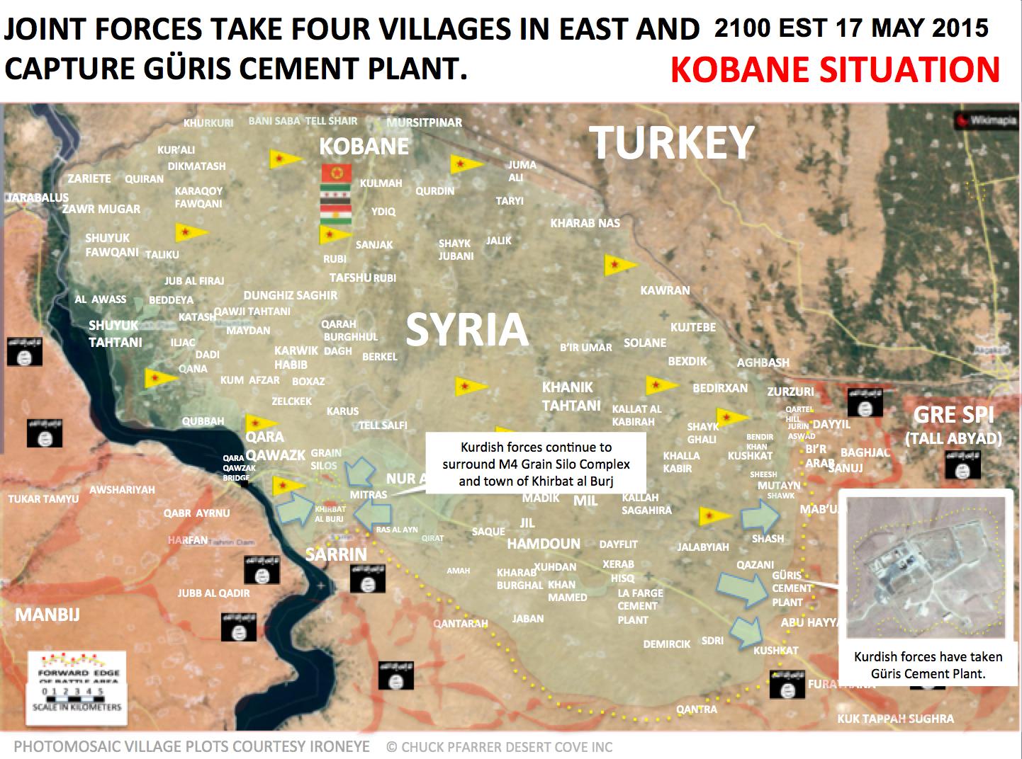
- DuckZz Pro Kurdish source reported that the Kurdish forces capture Güris Cement Plant east of Kobane.here so maybe YPG/rebels for now still in this area. But I search more data. Hanibal911 (talk) 15:13, 18 May 2015 (UTC)
Rebels today took Baath Vanguard Camp just south of Mastumah; it is already green in the map. Supposedly they also took nearby Nahlaya as well as Kafr Najd (pro-opposition map). However, there is conflicting information about Nahlaya and Kafr Najd, so we need to wait for further information / confirmation by neutral or pro-government sources.131.188.48.167 (talk) 18:10, 19 May 2015 (UTC)
- Pro opposition source clear showed that the village of Kafr Najd still under control by Syrian troops.Syrian Rebellion Observatory and SOHR also not confirmed that the vullage Kafr Najd was taken by rebels. Hanibal911 (talk) 18:35, 19 May 2015 (UTC)
- And this pro opposition source also later reaffirmed that the village of Kafr Najd still under control by Syrian troops.Syrian Rebellion Observatory Hanibal911 (talk) 21:40, 19 May 2015 (UTC)
Hanibal911 You probably know what I'm going to ask you know, in related to Al Mastumah control ... lol. Yes i know what SOHR said but i have no idea why did they say Al Nusra. If they had part of this, then ok, but their members didn't even participate in taking Mastumah & area. There was no statement on twitter/facebook like they usually do when capturing a town or capturing with other forces. The main force was Jaish Fatah (Al Nusra is only part of them, we already know that 6 other groups are in it too). Ok now, for some sources. Reporter Hadi Abdalah says that Al Mastumah was captured by Jund Aqsa & Jaish Sunna (part of Jaish Fateh). Other reporter Abdul Oman says the same on 0:53.
- Orient News reporter says the same. All these groups (IF, Jund Aqsa, Jaish Sunna, Faylaq Sham) were posting pictures/videos, but Al Nusra channels did not, only reports that "Mujahedins entering Al Mastumah", and that's about it.
We both know that SOHR makes small mistakes in their reports, sometimes switching between names and puts Al Nusra instead of ISIS etc... what do you think ? DuckZz (talk) 00:14, 20 May 2015 (UTC)
- DuckZzAl Nusrah and its allies in the Jaysh al Fateh coalition are claiming to have completely overrun the Assad regime’s forces at the Al Mastoumah military camp in Idlib.The Long War Journal Rebels including Al-Qaeda’s local affiliate seized the Syrian regime’s largest remaining military base in northwestern Idlib province.he Daily Star So we know that fighters from Al Nusra also participated in the capture of the city, and we just do not have to ignore this fact. Nonetheless we marked all villages and military objects which also was taken the under control by moderate rebels. And in order to mark part of Al Nusra we mark under jointly control the town of Al Matsuma. Hanibal911 (talk) 06:23, 20 May 2015 (UTC)
Just for information: The rebels claim to have taken Jawma Checkpoint directly northeast of Ariha (map) - (tweet) - (video). We clearly have to wait for further information from neutral or pro-government sources, but the video seems to be genuine.131.188.48.167 (talk) 16:34, 20 May 2015 (UTC)
- Is this here a reliable / neutral source? It states that Rebels took al Jumah Checkpoint. 131.188.48.167 (talk) 12:47, 22 May 2015 (UTC)
- Source sometimes publishes not correct data. Source said that according to data from SOHR that the rebels had been engaged in clashes with regime forces in the village of Kafr Najd, southwest of Ariha but in report which source provide SOHR not said about clashes in this village.SOHR Hanibal911 (talk) 12:57, 22 May 2015 (UTC)
- And according to antigovernment source the village of Kafr Najd still control Syrian troops.here Hanibal911 (talk) 13:06, 22 May 2015 (UTC)
- Source sometimes publishes not correct data. Source said that according to data from SOHR that the rebels had been engaged in clashes with regime forces in the village of Kafr Najd, southwest of Ariha but in report which source provide SOHR not said about clashes in this village.SOHR Hanibal911 (talk) 12:57, 22 May 2015 (UTC)
North-West & South-West corner of Damascus map need to be changed
I have a question about the sliver of green/rebel land at the top left hand corner of the 'Damascus map', which includes the town of Wadi Barada. According to the recent detailed study put out by Christopher Kozak of the Institute for the Study of War (ISW) this area has a ceasefire agreement with the government. If this is accurate then that area should be changed to purple. See the map on page 24 of the ISW report: http://understandingwar.org/sites/default/files/An%20Army%20in%20All%20Corners%20by%20Chris%20Kozak%201.pdf Does anyone have further information about this area?
- A small clarification: this the antigovernment source and we cant use him data against the Syrian troops and data from this source cant be use for displayed success of all troops which against Syrian troops. Only for displayed success of army and Kurdish forces. Source named the Syrian troops as regime troops or Assad troops and sometime Assad forces. And named governement as regime or Assad regime. But this not neutral providing information. We made only one exception for SOHR because his data uses many reliable sources. Hanibal911 (talk) 16:18, 18 May 2015 (UTC)
- Yes, it is an anti-government source. However, currently that area is marked Green. So this is an anti-government source that would verifying that the area is not green but is actually purple (a truce area), so that would actually be an improvement for the government. It is an antigovernment source showing a gain for the government as a truce has been achieved. ISW is closely linked with US foreign policy and military establishment, if it shows a gain for the Assad government that should be taken seriously. Remember the wiki rules - anti-governemnt or neutral sources to show government gains, anti-rebel or neutral sources to show rebel gains.
- I agree with the suggestion. I always suspected that this area was on truce. There have been little or no clashes since a long time.Paolowalter (talk) 20:46, 18 May 2015 (UTC)
That map also indicates that the left bottom green area south of Khan al Shih is fully Government held, with exception of the town itself.MesmerMe (talk) 21:20, 18 May 2015 (UTC)
The Damascus map is outdated because SOHR, Al Masdar etc have already reported about rebel advances near the 39.brigade, Haws Farah, north of Madaya etc, but that's old and if you edit the map now it will look like rebels are besieged near these bases ... DuckZz (talk) 11:35, 19 May 2015 (UTC)
Then fix the map. The whole point of this map is to reflect the actual changes taking place on the ground. Also you do not address the urgent need to change the top left corner that includes Wadi Barada. This area is in cease fire but it is painted green. It has been painted green for far too long. Rebel area in south-west corner also should seriously shrunken , as shown on that map. Is this going to be changed? ISW study (close with US power establishment,pentagon,etc) shows this to be true. Why is not being fixed? — Preceding unsigned comment added by 169.231.159.206 (talk) 20:59, 19 May 2015 (UTC)
- It has not been changed (or had not been, not checked if it has) because it requires knowledge of editing .svg files to edit, which not many of us are used to doing. In fact, one edit has done most of the updates to it. Has someone asked the usual guy to do it? Banak (talk) 20:31, 20 May 2015 (UTC)
YPG advances against ISIS
SOHR reported that the violent clashes are still continuing between ISIS and YPG in the rural area between the town of Tell Tamer and countryside of city Ras al-Ain where YPG take control of the two villages.SOHR Hanibal911 (talk) 18:12, 18 May 2015 (UTC)
Several villages have been taken by YPG last week, our map looks very outdated, especially around Manajir. These are the names of the villages taken today: https://twitter.com/issa_kobani/status/600376344833294336 https://twitter.com/issa_kobani/status/600377317953773568 https://twitter.com/issa_kobani/status/600377889767432192 https://twitter.com/issa_kobani/status/600378496003788800 Of course this is a kurdish source, but I think that the last numerous SOHR reports are corroborating this kurdish reports, even if SOHR doesn't tell nothing about the names of the villages. --8fra0 (talk) 19:27, 18 May 2015 (UTC)
- There are dozens of sources which confirm YPG advance, sweeping ISIS of the southern villages of Tal Tamer, advancing towards Mount Abdalaziz (Mount Kizwan):
- http://www.alahednews.com.lb/fastnews/272465/-%D8%A7%D9%84%D9%88%D8%AD%D8%AF%D8%A7%D8%AA-%D8%A7%D9%84%D9%83%D8%B1%D8%AF%D9%8A%D8%A9-%D8%AA%D8%B3%D9%8A%D8%B7%D8%B1-%D8%B9%D9%84%D9%89-%D9%82%D8%B1%D9%89-%D8%AC%D9%86%D9%88%D8%A8-%D9%85%D8%AF%D9%8A%D9%86%D8%A9-%D8%AA%D9%84-%D8%AA%D9%85%D8%B1-%D8%A8%D8%B1%D9%8A%D9%81-%D8%A7%D9%84%D8%AD%D8%B3%D9%83%D8%A9-%D9%88%D8%AA%D9%82%D8%AA%D9%84-26-%D9%85%D8%B3%D9%84%D8%AD%D8%A7%D9%8B#.VVpIpvmqqko
- http://www.alboselh.net/node/5216
- http://smartnews-agency.net/news/51953
- http://smartnews-agency.net/news/51936 Roboskiye (talk) 20:39, 18 May 2015 (UTC)
- Roboskiye stop using arabic sources and pro-kurd sources this goes for 8fra0 you are just vandalizing the map if 1 or 2 villages are confirmed captured by reliable source you go and add or change 7-10 villages at once without any confrimation.Lindi29 (talk) 13:07, 19 May 2015 (UTC)
- SOHR reported that in the last 48 hours the YPG take control over about 20 villages in the west, southeast, south and northwest of the province of Hasakah province.SOHRSOHR Hanibal911 (talk) 20:16, 19 May 2015 (UTC)
http://www.agathocledesyracuse.com/wp-content/uploads/2015/04/Hasakah-western-front-19-May-2015.jpg YPG made modest advances and has a pocket in its rear. Tgoll774 (talk) 22:53, 19 May 2015 (UTC) the map is accurate,i recommend the hasakah section of the wikipedia map to be updated to agathocle's map.Alhanuty (talk) 01:14, 20 May 2015 (UTC)
- Update: YPG takes over control of the radio tower (communication facilities) on Mount Abdalaziz http://www.alahednews.com.lb/fastnews/272737/-%D8%A7%D9%84%D9%88%D8%AD%D8%AF%D8%A7%D8%AA-%D8%A7%D9%84%D9%83%D8%B1%D8%AF%D9%8A%D8%A9-%D8%AA%D9%8F%D8%B3%D9%8A%D8%B7%D8%B1-%D8%B9%D9%84%D9%89-%D9%82%D9%85%D8%A9-%D8%AC%D8%A8%D9%84-%D8%B9%D8%A8%D8%AF%D8%A7%D9%84%D8%B9%D8%B2%D9%8A%D8%B2-%D9%81%D9%8A-%D8%B1%D9%8A%D9%81-%D8%A7%D9%84%D8%AD%D8%B3%D9%83%D8%A9-%D8%A7%D9%84%D8%B4%D9%85%D8%A7%D9%84%D9%8A-%D8%A8%D8%B9%D8%AF-%D8%A7%D8%B4%D8%AA%D8%A8%D8%A7%D9%83%D8%A7%D8%AA-%D9%85%D8%B9#.VVwyk_mqqko . YPG controls now the mountain + cut the eastern and western roads to villages north of it. Roboskiye (talk) 07:14, 20 May 2015 (UTC)
- Visual evidence for YPG in control of communication facilities on top of Mount Abdalazi (Mount Kizwan):
- http://hawarnews.com/%D9%88%D8%AD%D8%AF%D8%A7%D8%AA-%D8%A7%D9%84%D8%AD%D9%85%D8%A7%D9%8A%D8%A9-%D8%AA%D8%B5%D9%84-%D8%A5%D9%84%D9%89-%D9%82%D9%85%D8%A9-%D8%AC%D8%A8%D9%84-%D9%83%D8%B2%D9%88%D8%A7%D9%86/
- http://hawarnews.com/wp-content/uploads/2015/05/cd1742a08ae3dddbde9b5ed05d709304e0a2cdbe719c7b34c0d8bf26de5f3fdd.jpg
- http://hawarnews.com/wp-content/uploads/2015/05/5392c28fd4b5626aea40ce2446cbf810452fcd17b01746f4754209da373a8919.jpg
- http://hawarnews.com/wp-content/uploads/2015/05/dc6c1b418d46845f75ce6d09a87bb2c39667652f9d6415ababc659fa0bc07de4.jpg Roboskiye (talk) 09:00, 20 May 2015 (UTC)
Some more villages have been taken by YPG yesterday and today: http://anfenglish.com/kurdistan/ypg-15-villages-liberated 8fra0 (talk) 14:03, 22 May 2015 (UTC)
- SOHR also reported about clashes continued between YPG and ISIS in the south-western countryside to the city of Ras Al Ain wher YPG take control at least the two villages also clashes took place between YPG with support Syrian Army against ISIS in the rural area between the town Tel Tamer and Mountain area Abdel-Aziz.SOHR Hanibal911 (talk) 20:02, 23 May 2015 (UTC)
Palmyra contested?
http://syrian-mirror.net/en/cat/syria-mirror/isis-tighten-control-over-the-northern-district-of-palmyra-amid-dire-living-conditions/ Tgoll774 (talk) 03:56, 20 May 2015 (UTC)
- This biased antigovernment source. SOHR and all relaible sources clear said that clashes outside the city. Hanibal911 (talk) 06:30, 20 May 2015 (UTC)
- SOHR clear said that the clashes between Syrian troops and their allies on the one hand, and elements of the "Islamic State" on the other hand near of the city of Palmyra.SOHR Clashes between ISIS against pro-government forces north of the city of Palmyra. Earlier regime forces pushed ISIS out of northern neighbourhoods of Palmyra. Further north, fighting between IS jihadists and government forces continued outside Palmyra.France 24I24 NewsThe Daily Star Also we cant used biased antigovernment sources against Syrian troops. Hanibal911 (talk) 06:49, 20 May 2015 (UTC)
- Despite all the propaganda statements that make pro ISIS activits or pro ISIS sources relaible sources clear said that the clashes still ongoing near the city of Palmyra.The GuardianThe Daily StarSOHRNaharnet Hanibal911 (talk) 10:44, 20 May 2015 (UTC)
- Hanibal911, Naharnet says ISIS took one third of Palmyra. Daily Star says ISIS took the north part. SOHR says clashes in the surrounding areas, but also in the prison and the political security building. If you understand Arabic, that's pretty clear that the clashes are inside the city. Please stop trying to use semantics to minimize regime losses, you made Ziyara and Qastoun contested on far less. NightShadeAEB (talk) 13:58, 20 May 2015 (UTC)
- NightShadeAEB Yes they take 30% of city. Hanibal911 (talk) 14:29, 20 May 2015 (UTC)
- BBC states ISIS has taken the northern part of Palmyra here: http://www.bbc.co.uk/news/world-middle-east-32807858 Alastairjc (talk) 14:36, 20 May 2015 (UTC)
- NightShadeAEB Yes they take 30% of city. Hanibal911 (talk) 14:29, 20 May 2015 (UTC)
- Hanibal911, Naharnet says ISIS took one third of Palmyra. Daily Star says ISIS took the north part. SOHR says clashes in the surrounding areas, but also in the prison and the political security building. If you understand Arabic, that's pretty clear that the clashes are inside the city. Please stop trying to use semantics to minimize regime losses, you made Ziyara and Qastoun contested on far less. NightShadeAEB (talk) 13:58, 20 May 2015 (UTC)
- Despite all the propaganda statements that make pro ISIS activits or pro ISIS sources relaible sources clear said that the clashes still ongoing near the city of Palmyra.The GuardianThe Daily StarSOHRNaharnet Hanibal911 (talk) 10:44, 20 May 2015 (UTC)
- SOHR clear said that the clashes between Syrian troops and their allies on the one hand, and elements of the "Islamic State" on the other hand near of the city of Palmyra.SOHR Clashes between ISIS against pro-government forces north of the city of Palmyra. Earlier regime forces pushed ISIS out of northern neighbourhoods of Palmyra. Further north, fighting between IS jihadists and government forces continued outside Palmyra.France 24I24 NewsThe Daily Star Also we cant used biased antigovernment sources against Syrian troops. Hanibal911 (talk) 06:49, 20 May 2015 (UTC)
- ISIS take 30% of the city Palmyra.Charles Lister Hanibal911 (talk) 14:44, 20 May 2015 (UTC)
- Pro-regime source says the city has fallen (although opposition sources deny the airport and prison fell). You know the rules. https://www.facebook.com/permalink.php?story_fbid=837292089682576&id=834837069928078 NightShadeAEB (talk) 18:13, 20 May 2015 (UTC)
- SOHR said that they still fighting http://www.syriahr.com/2015/05/%D8%A7%D8%B3%D8%AA%D9%85%D8%B1%D8%A7%D8%B1-%D8%A7%D9%84%D8%A7%D8%B4%D8%AA%D8%A8%D8%A7%D9%83%D8%A7%D8%AA-%D8%A7%D9%84%D8%B9%D9%86%D9%8A%D9%81%D8%A9-%D9%81%D9%8A-%D8%AA%D8%AF%D9%85%D8%B1-%D8%A8%D8%B9/ 217.99.132.128 (talk) 18:34, 20 May 2015
- More reliable source SOHR reported that the violent clashes are still continuing between Syrian troops and ISIS in the city of Palmyra and its outskirts.SOHR And pro government source aslo reported that the city not fallen.here Hanibal911 (talk) 18:35, 20 May 2015 (UTC)
- Leith fadel claiming SAA left https://twitter.com/leithfadel/status/601104187120816128 — Preceding unsigned comment added by 2601:0:5280:449:8D12:EF37:CFB1:C53 (talk) 19:30, 20 May 2015 (UTC)
- SOHR said that they still fighting http://www.syriahr.com/2015/05/%D8%A7%D8%B3%D8%AA%D9%85%D8%B1%D8%A7%D8%B1-%D8%A7%D9%84%D8%A7%D8%B4%D8%AA%D8%A8%D8%A7%D9%83%D8%A7%D8%AA-%D8%A7%D9%84%D8%B9%D9%86%D9%8A%D9%81%D8%A9-%D9%81%D9%8A-%D8%AA%D8%AF%D9%85%D8%B1-%D8%A8%D8%B9/ 217.99.132.128 (talk) 18:34, 20 May 2015
- Pro-regime source says the city has fallen (although opposition sources deny the airport and prison fell). You know the rules. https://www.facebook.com/permalink.php?story_fbid=837292089682576&id=834837069928078 NightShadeAEB (talk) 18:13, 20 May 2015 (UTC)
Tadmur seized by IS
https://twitter.com/leithfadel/status/601104187120816128
http://www.syriahr.com/2015/05/%D8%A7%D9%86%D9%87%D9%8A%D8%A7%D8%B1-%D9%82%D9%88%D8%A7%D8%AA-%D8%A7%D9%84%D9%86%D8%B8%D8%A7%D9%85-%D8%A3%D9%85%D8%A7%D9%85-%D8%AA%D9%86%D8%B8%D9%8A%D9%85-%D8%A7%D9%84%D8%AF%D9%88%D9%84%D8%A9-%D8%A7/ — Preceding unsigned comment added by 76.126.188.171 (talk) 19:53, 20 May 2015 (UTC)
And here is a pro-Regime source saying that IS at the very least has taken about 3/4s of the city. (3 hours ago) https://www.facebook.com/IslamicWorldNews.En/posts/827457690662030
And yet another source. https://twitter.com/Flea1337/status/601082986851885056
- How are the oil fields west of the city? I've heard Jabal has already fallen. — Preceding unsigned comment added by 2601:0:5280:449:8D12:EF37:CFB1:C53 (talk) 21:45, 20 May 2015 (UTC)
IS supporters are saying this place fell to IS http://wikimapia.org/#lang=en&lat=34.228587&lon=38.023896&z=16&m=b https://twitter.com/AdamThActivist/status/601422127498174464 Tgoll774 (talk) 16:58, 21 May 2015 (UTC)
- Syrian troops try to retake Palmyra.CNTV Hanibal911 (talk) 17:16, 21 May 2015 (UTC)
- That is odd. No word from Pro-Gov sources.XJ-0461 v2 (talk) 01:07, 22 May 2015 (UTC)
- XJ-0461 v2 Syrian Armed Forces Prepare for Counter-Assault at Palmyra.Al Masdar Hanibal911 (talk) 06:41, 22 May 2015 (UTC)
- That article also states that the regime has been securing the perimeter of T4 airbase, so I think that there won't be a counter assault. — Preceding unsigned comment added by 76.126.188.171 (talk) 08:31, 22 May 2015 (UTC)
- XJ-0461 v2 Syrian Armed Forces Prepare for Counter-Assault at Palmyra.Al Masdar Hanibal911 (talk) 06:41, 22 May 2015 (UTC)
- That is odd. No word from Pro-Gov sources.XJ-0461 v2 (talk) 01:07, 22 May 2015 (UTC)
- Source said that Syrian troops just fortified the perimeter of Air Base to avoid the situation that occurred in the city of Palmyra. When the army of poorly consolidated its position and it allowed ISIS make sudden attack and capture the city. Hanibal911 (talk) 09:05, 22 May 2015 (UTC)
Damascus map still needs updating
Top left hand corner of the 'Damascus map', which includes the town of Wadi Barada is in peace treaty and the left bottom green area south of Khan al Shih is fully Government held. This, according to anti-government researcher Christopher Kozak & the pentagon connected Institute for the Study of War (ISW). See Page 24 of the ISW report: http://understandingwar.org/sites/default/files/An%20Army%20in%20All%20Corners%20by%20Chris%20Kozak%201.pdf Is the map going to be fixed? — Preceding unsigned comment added by 71.102.129.170 (talk) 22:17, 20 May 2015 (UTC)
- MrPenguin20 is the guy who normally sorts out the SVG maps. I'll give it a go if it's not done in a week. Banak (talk) 22:34, 20 May 2015 (UTC)
- On it! MrPenguin20 (talk) 21:12, 21 May 2015 (UTC)
- Updated. Kozak seems to have mislabeled Artouz (where I don't think there is much opposition presence) as Khan al-Shih (where there is). I've updated the map though to show the general gist of what he's saying - that the extent of opposition control around Khan al-Shih is limited. Also updated Wadi Barada area. MrPenguin20 (talk) 02:09, 25 May 2015 (UTC)
Sheikh Najjar Industrial City
https://twitter.com/AdamThActivist/status/601417059529039873 Claims Assad is being fought by IS in this outskirt of Aleppo. Pro-FSA sources are saying the same thing such as Malcomite https://twitter.com/Malcolmite/status/601429620148305921 Leave it to the usual to see what the Arabic sources say. Tgoll774 (talk) 17:03, 21 May 2015 (UTC)
- First source (pro ISIS) and secondly just biased antigovernemnt source. Need data from more reliable sources. Hanibal911 (talk) 17:13, 21 May 2015 (UTC)
a pro-government source is saying something about it https://twitter.com/DerekBisaccio/status/601433206626320384.Alhanuty (talk) 17:16, 21 May 2015 (UTC)
- This is pro gov? 99% news i pro opp source 217.99.132.128 (talk) 17:28, 20 May 2015 — Preceding unsigned comment added by 2A02:25AA:1:4004:0:0:0:6E (talk)
- Alhanuty Firstly this not pro government source. Need provide link to pro government source. Because any source can said that this data from the pro government source but not provide links on these sources. Hanibal911 (talk) 17:41, 21 May 2015 (UTC)
- Pro government source said that the Syrian soldier inside 3rd zone of Sheikh Najjar. And that Sheikh Najjar still under control of Syrian troops.here Hanibal911 (talk) 18:39, 21 May 2015 (UTC)
Neutral source also reporting IS took two villages east of Sheikh Najjar (not specified, but must be Muqbalah/Suran/Shamir) and is on the outskirts [1].Nhauer (talk) 21:05, 21 May 2015 (UTC)
- ISW is not a neutral source.XJ-0461 v2 (talk) 21:12, 21 May 2015 (UTC)
- Crikey, you guys can't even find a source that you agree presents accurate battlefield reports. No wonder everyone over there is killing each other. Magog the Ogre (t • c) 00:05, 22 May 2015 (UTC)
- Guys,it's just a matter of time till the confirmation will be announced from reliable source, beacause pro-gov sources are figuring it out how to waste time with their propaganda on this case 1 day mb 2??,just like the case in Palmyra,Hanibal911 you see what did i tell you.Lindi29 (talk) 00:39, 22 May 2015 (UTC).
- Interestingly, ISIS has no boarder with the Industrial area, that is rebel controlled. Interesting how ISIS appeared out of nowhere. XJ-0461 v2 (talk) 00:57, 22 May 2015 (UTC)
- This not neutral source this antigovernment sourceISW and pro govevernment source clear said that ISIS assault was repelled by the Syrian troops after the fierce clashes erupted at the 3rd Zone in the southeastern part of the Industrial District.here Hanibal911 (talk) 06:14, 22 May 2015 (UTC)
- Why is it that 90% of the time here the 'pro-government source' is Al-Masdar, which is run by Leith Fadel, is incredibly unreliable/biased and has been even worse than normal since the fall of Idlib? There's a reason this map is falling behind others in terms of updating and is seen as pro-regime by a lot of people, because if you have to wait until Leith personally approves info to include it on the map then you will always have a biased picture of the situation. This was evident with Palmyra where this map had Amiriya marked as under SAA control (based on Leith) when in fact ISIS had never withdrawn from there, only the city itself. Al-Masdar is straight up regime propaganda a lot of the time and really shouldn't be used at all, I am not pro-rebel but SOHR is much more accurate when reporting territorial gains for any side in this war.Nhauer (talk) 11:44, 22 May 2015 (UTC)
- This not neutral source this antigovernment sourceISW and pro govevernment source clear said that ISIS assault was repelled by the Syrian troops after the fierce clashes erupted at the 3rd Zone in the southeastern part of the Industrial District.here Hanibal911 (talk) 06:14, 22 May 2015 (UTC)
- Interestingly, ISIS has no boarder with the Industrial area, that is rebel controlled. Interesting how ISIS appeared out of nowhere. XJ-0461 v2 (talk) 00:57, 22 May 2015 (UTC)
- ISW is not a neutral source.XJ-0461 v2 (talk) 21:12, 21 May 2015 (UTC)
- Wha are you talking about??? If anything this map has been more biased toward promoting the jihadist/islamist rebels. Just look at the map of Damascus. The top left corner has been in ceasefire for a while now but it remains painted green. The bottom left hand corner is controlled by government, but has remained painted green. This according to Pentagon connected Think Tank with detailed information on the war. — Preceding unsigned comment added by 169.231.26.212 (talk) 14:31, 22 May 2015 (UTC)
- Also SOHR not said that ISIS captured part of Sheikh Najjar. And this blog is a biased antigovernment source which is a long time opposes to Syrian government.ISW Hanibal911 (talk) 12:38, 22 May 2015 (UTC)
- Hanibal911 here is a reliable source who confrims that.here,and again XJ-0461 v2 this confrims the propaganda of leith fadel he said first there are no Isis there now it says the attack is replled,just like the case in Palmyra where he tweted "Palmyra has not fallen stop the propaganda" then 1 hour late "The army has withdrawn from Palmyra".Lindi29 (talk) 14:20, 22 May 2015 (UTC)
- So it took an extra day to fix the map in Palmyra. So what. The map in damascus has been wrong and slanted toward the religious fanatic rebels for months- even while top and bottom left hand corners should not be green. — Preceding unsigned comment added by 169.231.26.212 (talk) 14:32, 22 May 2015 (UTC)
- Lindi29 But for now not one reliable source not confirmed that ISIS captured part of Sheikh Najjar including SOHR. Hanibal911 (talk) 15:27, 22 May 2015 (UTC)
- So it took an extra day to fix the map in Palmyra. So what. The map in damascus has been wrong and slanted toward the religious fanatic rebels for months- even while top and bottom left hand corners should not be green. — Preceding unsigned comment added by 169.231.26.212 (talk) 14:32, 22 May 2015 (UTC)
Almasdar News
They used the map without source, http://www.almasdarnews.com/article/complete-battle-map-of-syria//, Omega933 (talk) 07:07, 22 May 2015 (UTC)
- And your point is? MesmerMe (talk) 11:22, 22 May 2015 (UTC)
Kafr Najd, Idlib
There have been many reports on the Ariha-front lines in Idlib province. The Jaysh al-Fatah army has taken over Mastumah and nearby towns last week. I have found this article which details the fall of the Jisr ash-Shugur Hospital. It also mentions clashes in the village of Kafr Najd and around checkpoints west of Ariha. So that would mean: Kafr Najd to contested, and a green semi-ring around Ma'ataram west of Ariha. Everybody agreed? Report: https://now.mmedia.me/lb/en/NewsReports/565321-regimes-idlib-front-collapsing — Preceding unsigned comment added by 84.24.43.183 (talk) 14:39, 22 May 2015 (UTC)
- This source made mistake when he said that clashes in Kafr Najd. Because he provide because he provide link on this report from SOHR here but this report not said that clashes in this village. Also many data in this source from pro oppositions sources. I only marked according to this source as under control of rebels Jawma checkpoint. And according to antigovernment source the village of Kafr Najd still control Syrian troops.here Hanibal911 (talk) 15:23, 22 May 2015 (UTC)
- SOHR clear said that the clashes between Syrian troops and their allies against Islamic factions in the vicinity of the town of Kafr Najd to south-west of the city of Ariha. So SOHR cleas said that no clashes in Kafr Najd only near this town.SOHR So that source distort data from SOHR in his article. Hanibal911 (talk) 15:33, 22 May 2015 (UTC)
Qalamoun offensive
Syrian troops and Hezbollah taken control of most of Qalamoun, rebels fleeing north toward the outskirts of Arsal(Lebanon)The Dailt Star Hanibal911 (talk) 15:56, 22 May 2015 (UTC)
- According sayed_ridha Hezbollah takes control of Talet Sadr Al-Bustan (2601m) which is north of Talet Musa 217.99.132.128 (talk) 09:32, 23 May 2015
- Here this hill on map Talet Sadr Al-Bustan Hanibal911 (talk) 11:43, 23 May 2015 (UTC)
- SOHR also reported about clashes between Islamic fighters and Al-Nusra against Hezbollah/NDF in Jarrod Kalamoon in Lebanon and said about progress of Hezbollah and NDF against Al Nusra in this area.SOHR So that SOHR also indirectly confirmed this data. Hanibal911 (talk) 14:09, 23 May 2015 (UTC)
- Here this hill on map Talet Sadr Al-Bustan Hanibal911 (talk) 11:43, 23 May 2015 (UTC)
Another advace almasdar Hezbollah Captures the Western Hills of Tal Thaljah in the Qalamoun Mountains and almasdar Hezbollah Captures Al-Qaba’ and Al-Niqar on the border of Nahleh dailystar confirm this. 217.99.132.128 (talk) 12:52, 25 May 2015
Hanibal911 There should be a rural presence icon, clashes are still reported DuckZz (talk) 14:55, 25 May 2015 (UTC)
- DuckZz Reliable source two days ago clear said that Syrian army and Hezbollah taken most of Qalamoun and rebels fleeing toward outskirts of Arsal and some rebels retreated to border where still ongoing sporadic clashes.The Daily Star So that for now mainly clashes going on territory Lebanon and in some areas near border. But this to small area and we cant put this icon. Now the main battles in the area of Qalamoun but on Lebanese territory. Becasue most part of area which earlier was taken by rebels/Al Nusra is located on Lebanon territory. Also for now some reliable sources clear said that for now the troops and Hezbollah advance and take new area in north part Qalamoun wher still present ISIS fighters and some fightrers from Al Nusra which earlier retreated from most part Qalamoun. Hanibal911 (talk) 15:34, 25 May 2015 (UTC)
- Also today the reliable source clear said that the Syrian troops backed by Hezbollah fighters, launched an offensive in Qalamoun earlier this month, capturing dozens of rebel bases and driving their north toward the outskirts of Lebanon's Arsal.The Daily Star Hanibal911 (talk) 08:45, 26 May 2015 (UTC)
Syrian troops advances against ISIS south of Hasakah
SOHR reported about clashes between NDF against ISIS in white area in the south-western countryside of Hasaka where the Syrian troops during the past two days of advances against ISIS and take control of the some areas that earlier were controlled by the "Islamic state".SOHR And pro government source reported that Syrian troops advanced in the direction city of Shaddadeh.here Hanibal911 (talk) 13:22, 23 May 2015 (UTC)
- Syrian troops backed by NDF made gains in Hasakah Province, where they retook several areas from the ISIS in the western and southwestern regions this province.Press TV Hanibal911 (talk) 13:46, 23 May 2015 (UTC)
- Pro opposition source said that the Syrian troops take control village of Tall Baroud in Hasaka countryside, after severe clashes with Islamic State.Documents.Sy Hanibal911 (talk) 14:25, 23 May 2015 (UTC)
- Hanibal911 this were 3 pro-gov source,except from SOHR.Lindi29 (talk) 16:14, 23 May 2015 (UTC)
- Lindi29Documents.Sy this pro opposition source source he just use Syrian flag but he is not support Syrian government as SOHR use opposition flag on his web site but we use him as a neutral. This source many times uses as a sources videos from the rebels.herehere He just not called the Syrian troops as "regime forces" as this do SOHR. But many times was confirmed that this antigovernment source. And I know that both these sources sources (Press TV and here) I just provide data from the pro opposition source from pro government sources and from SOHR. Hanibal911 (talk) 16:36, 23 May 2015 (UTC)
Lindi29 are you ISIL supporter ? you always try to prove ISIL advances and try to stop ISIL defeats .86.135.157.236 (talk) 18:36, 23 May 2015 (UTC)
- Stop Ad hominem attacks. --햄방이 (talk) 18:45, 23 May 2015 (UTC)
- Ip I am neutral editor I dont support any of this factions,The offenisve against Isis in the Tall Tamer and Ras al Rayn are true I am not trying to stop they defeats SOHR confirms that but editors alleged pro-kurd ones are editing with pro-kurd sources and arabic which is against the rules and are vandalizing the map if you see,If you pay attention to the rules than you will understand in this case that i replied to Hanibal911 i just mentioned only that he provided 3 pro-gov sources,exepct from SOHR i was having problem with the Documents.sy source beacause all pro-opp sources use other flag they dont use the one that Assad Faction,it's really suspicious to me.If you have doubt that what I was talking than ask Hanibal911 about the rules of editing with a reliable source and pro-side source.Lindi29 (talk) 13:43, 24 May 2015 (UTC)
- This source(Documents.Sy) long time opposes against Syrian government and mainly publishes data about success of the rebels in the fight against the Syrian army. But he just use official Syrian flag on main page because this flag still is the official a flag of Syrian republic but this not said that this pro government source. SOHR uses flag of Syrian opposition but we use him as a neutral source. Hanibal911 (talk) 15:13, 24 May 2015 (UTC)
- Ip I am neutral editor I dont support any of this factions,The offenisve against Isis in the Tall Tamer and Ras al Rayn are true I am not trying to stop they defeats SOHR confirms that but editors alleged pro-kurd ones are editing with pro-kurd sources and arabic which is against the rules and are vandalizing the map if you see,If you pay attention to the rules than you will understand in this case that i replied to Hanibal911 i just mentioned only that he provided 3 pro-gov sources,exepct from SOHR i was having problem with the Documents.sy source beacause all pro-opp sources use other flag they dont use the one that Assad Faction,it's really suspicious to me.If you have doubt that what I was talking than ask Hanibal911 about the rules of editing with a reliable source and pro-side source.Lindi29 (talk) 13:43, 24 May 2015 (UTC)
We should remove IS supply route to Hama/Homs now
Capture of al-Jazl gives them a direct road connection via Palmyra. Thus we can remove that superfluous dot collection Tgoll774 (talk) 18:03, 23 May 2015 (UTC)
- When did ISIS take those 3 bases north of Palmyra? I thought they were holding out. — Preceding unsigned comment added by 2601:0:5280:449:8D12:EF37:CFB1:C53 (talk) 20:04, 23 May 2015 (UTC)
- Also, when did IS take the Jazal Oilfields? Pro SAA reports still report fighting there. MesmerMe (talk) 10:49, 24 May 2015 (UTC)
- When did ISIS take those 3 bases north of Palmyra? I thought they were holding out. — Preceding unsigned comment added by 2601:0:5280:449:8D12:EF37:CFB1:C53 (talk) 20:04, 23 May 2015 (UTC)
Sarrin and Nearby area
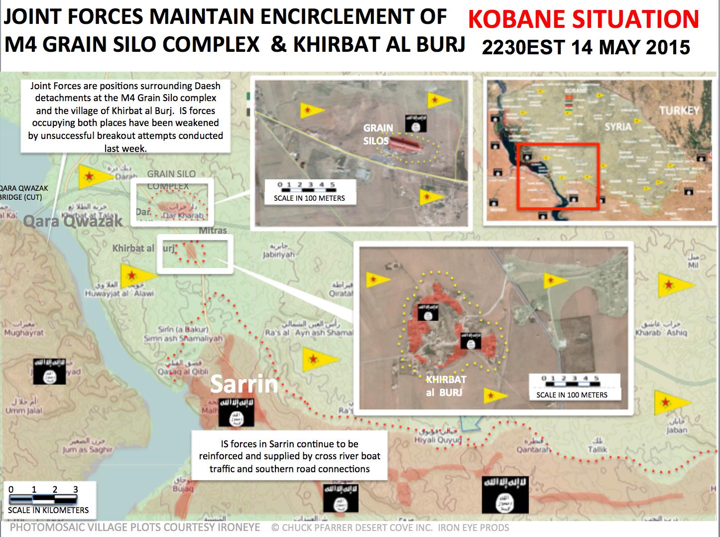
I found out that the Islamic State's positions in Dar Kharab and Khirbat al Burj are fully surrounded by Kurdish and Free Syrian Army. Furthermore pro-Kurdish forces showed Sarrin is under the Islamic State control, but Kurds are near to there. # --햄방이 (talk) 16:41, 24 May 2015 (UTC)
- You are wrong because you provide outdated source for 14 May. Also more detailed maps from pro Kurdish source clear showed that the city of Sarrin long time contested.for 26 Aprilfor 3 Mayfor 10 Mayfor 19 May Hanibal911 (talk) 17:28, 24 May 2015 (UTC)
- New pro Kurdish source also clear showed that the city of Sarrin still contested.here Hanibal911 (talk) 13:14, 25 May 2015 (UTC)
https://7496bff410df41fc380ad565a50f607d4b1e8372.googledrive.com/host/0BzN49CdHSAwmcGU4eEI5dVBGZXM/KobaniCantonKU-2015-05-25.png Shows a IS counter attack has linked Khirbat al-Furj with Sarrin and taken a stretch of M4. http://sfha.li/nasit/ This clearly shows IS holding an open air market on the Outskirts of Sarrin where YPG says they are. Obviously YPG isn't there. Sarrin must go to black. Tgoll774 (talk) 13:52, 25 May 2015 (UTC)
Aleppo map needs updating
In addition to Damascus map needing update, the Aleppo map also needs update. According to both pro-opp & now pro-gov sources the IS head choppers have overcome some of the red and green areas in eastern Aleppo- see this map: http://www.almasdarnews.com/article/battle-map-of-the-sheikh-najjar-industrial-district-of-aleppo/ — Preceding unsigned comment added by 169.231.26.212 (talk) 17:01, 24 May 2015 (UTC)
- MrPenguin20 is the guy who normally sorts out the SVG maps.Lindi29 (talk) 17:08, 24 May 2015 (UTC)
- Updated to show advance. I'll try and work out where the boundary between non-ISIS opposition and ISIS lies. MrPenguin20 (talk) 02:46, 25 May 2015 (UTC)
Hanibal911 The village of Sheikh Muhammed is really small, as you can see here. Instead of that, we can remove this village and add Rasm Kabahar on the same spot because rebels should control this village because it's on the same road as Rashidiyah, probably from where of they started the attacks, because it's not possible to control Rashidiyah without Rasm Kabahar. DuckZz (talk) 12:28, 25 May 2015 (UTC)
- DuckZz As I said early we edit only on based data from reliable sources but not on the basis of assumptions. So that SOHR said that rebels captured Sheikh Muhammed and Rashidiyah and we markd this villages as under control by rebels and it is all. Also attack on the village can not only from the road. But if a reliable source confirmed this data, we will do so. Otherwise these changes on the basis of assumptions will be repeated so some villages will be marked wrong only on the basis of assumptions. I hope for your understanding. Hanibal911 (talk) 12:39, 25 May 2015 (UTC)
- DuckZz Also SOHR and pro oppositions source reported that later the Syrain troops recaptured village of Rashidiyah.SOHRStep News Agency also another pro opposition source said that the Syrian troops recaptured villages of Jub Awad and Qurbatia.here and also said that the rebels withdrew with captured weapons from village of Rashidiyah and from surrounding areas after counterattack the Syrian troops.here Hanibal911 (talk) 19:54, 25 May 2015 (UTC)
Hanibal911 You probably don't understand the difference between being pro-opposition and being reliable. For example, Eliah Magnier is pro-government orianted, but he's reliable, so we use him as a source. This dude BosnoSin writes mostly about rebel stuff, but there's a difference because he is reliable, while not being pro-rebel (being pro-rebel means that he writes about regime, Bashar and other stuff not realated to the situation on the ground). There's not a single post by him that was actually wrong, so he has a 100% accuracy, which means he's realiable. DuckZz (talk) 20:15, 25 May 2015 (UTC)
- I am so confused. How could you possibly think EJM is pro Syrian Government? It is not like he ignores rebel victories or says "long live Assad " all day long. XJ-0461 v2 (talk) 22:17, 25 May 2015 (UTC)
DuckZ you failed once again. Bosnosin calls al nusra beheaders "rebels" and reported Rashidiya captured without any evidence meanwhile it was not even half captured. 100% accuracy LOL Totholio (talk) 21:19, 25 May 2015 (UTC)
- DuckZz Stop talking nonsense this guy on 100% pro opposition activist he basicly said about rebels advnces and many times he writes misinformation that troops are going to retreat from the city Araiha or even from the Idlib province trying to exaggerate the successes of the rebels. If he writes Srian army this not said that hisr a neutral(reliable) becasue he basicly writes about rebels victory and republishes data from pro-IF source and some other rebel sources. So stop said that he is a neutral. But Eliah Magnier it is a neutral source he is a chief international correspondent of AL Rai(the Kuwaiti newspaper) and this confirmed very relaible source British national morning newspaper The Independent This source clar said "Elijah J Magnier, the chief international correspondent for Al-Rai Media" Hanibal911 (talk) 06:37, 26 May 2015 (UTC)
- And opposition source reported that the Syrian troops retake villages of Rashadiyah and Sheikh Mohamed near the town of Khanasir.Archicivilians Hanibal911 (talk) 12:52, 26 May 2015 (UTC)
- DuckZz Stop talking nonsense this guy on 100% pro opposition activist he basicly said about rebels advnces and many times he writes misinformation that troops are going to retreat from the city Araiha or even from the Idlib province trying to exaggerate the successes of the rebels. If he writes Srian army this not said that hisr a neutral(reliable) becasue he basicly writes about rebels victory and republishes data from pro-IF source and some other rebel sources. So stop said that he is a neutral. But Eliah Magnier it is a neutral source he is a chief international correspondent of AL Rai(the Kuwaiti newspaper) and this confirmed very relaible source British national morning newspaper The Independent This source clar said "Elijah J Magnier, the chief international correspondent for Al-Rai Media" Hanibal911 (talk) 06:37, 26 May 2015 (UTC)
Rebels/Al Nusrs offensive against Liwa Shuhada al-Yarmouk(pro ISIS) in Daraa
Pro opposition source Syrian Rebellion Observatory reported that after weeks of tension, FSA, Ahrar ash-Sham, Jaysh al-Islam, Al Nusra begun offensive against Liwa Shuhada al-Yarmouk in Daraa.here Also this source reported that the (ex-rebels and for now pro ISIS) Liwa Shuhada al-Yarmouk present in nearly 10 villages/strategic hills in west part of Daraa province. And that they have hundreds of fighters and dozens tanks.here Also pro thid source reported that after the fourteen hours the battles against Liwa Shuhada al-Yarmouk the Ahrar ash-Sham entered in the two town Bakker and Saham al-Jawlan.here and pro government source also reported that the rebels have retaking towns Saham AL-Jawlan and Bakkar after clashes with Yarmouk Martyrs Brigade (pro ISIS)here Hanibal911 (talk) 19:59, 24 May 2015 (UTC)
- Hello, Hanibal911. Please consider using line breaks and bullets to separate out different points. This makes it much easier for us to read. Magog the Ogre (t • c) 20:47, 24 May 2015 (UTC)
SOHR wrote something about this. DuckZz (talk) 21:59, 24 May 2015 (UTC)
- SOHR reported that the violent clashes continued between brigade Martyrs Yarmouk fighters and Al-Nusra, Islamic factions in the town of Saham Al-Jawlan and its surrounding countryside west of Daraa, amid mutual bombardment of the parties, which managed the victory of progress and control over large parts of the region of the town of Saham Al-Jawlan.SOHRSOHR Hanibal911 (talk) 07:06, 25 May 2015 (UTC)
- Any reason that entire corner of the map is counted as ISIS? Up from like 3 villages earlier? — Preceding unsigned comment added by 2601:0:5280:449:8D12:EF37:CFB1:C53 (talk) 02:51, 26 May 2015 (UTC)
Palmyra neighborood
Why all locations around Palmyra has been turned black? There are sources reporting SAA presence not far from Palmyra..Paolowalter (talk) 14:36, 25 May 2015 (UTC)
SOHR source from today. DuckZz (talk) 14:56, 25 May 2015 (UTC)
This information apperas to be unfounded. Never heard by any other source. Including pro-rebel. They cannot be taken seriously.Paolowalter (talk) 21:58, 25 May 2015 (UTC)
- :I suspect that SOHR gets its information regarding ISIS straight from ISIS in SAA vs ISIS situations.If you notice, the casualties are always much higher and more skewed in SAA vs ISIS than SAA vs Rebels.However, when the kurds fight ISIS, the death toll is almost 2 or 3:1 in favor of the kurds, how strange. Nevertheless, the pro-gov sources still seem adament about a coming counterattack, so we should leave the map as is for now. XJ-0461 v2 (talk) 22:14, 25 May 2015 (UTC)
Interesing news here and here This is pro gov source but mayby SAA not so far from Palmyra as on the map 217.99.132.128 (talk) 22:30, 25 May 2015 — Preceding unsigned comment added by 2A02:25AA:1:4004:0:0:0:6E (talk)
- No one is denying that the SAA may be to the west of Palmyra, I doubt they are a mile from the city but they control the road at least up to Al-qalbiya, To the South is where the route has been seen though. Speaking of which Pro-opp source stating ISIS has the Al-Busayri https://twitter.com/TaziMorocco/status/602863618565234692 — Preceding unsigned comment added by 2601:0:5280:449:8D12:EF37:CFB1:C53 (talk) 23:27, 25 May 2015 (UTC)
- This guy a antigovernment dreamer and his information should not even be considered. He wrote a few weeks ago that the rebels captured the almost entire plain of Al Ghab and the troops retreated from this area and many other not a true data. Hanibal911 (talk) 06:43, 26 May 2015 (UTC)
- But Iranian channel Press TV(pro government) showed that army still located near city of Palmyra.here So for now we have data from pro government source and from antigovernment source. But we need data from a reliable(a neutral) source. And SOHR reported that ISIS captured some areas around city and south from city including several gas fields and T3 Pumping station. So let's not argue and just wait more information from reliable sources. Hanibal911 (talk) 06:53, 26 May 2015 (UTC)
From http://www.almasdarnews.com/article/east-homs-erupts-with-violence-isis-attacking-multiple-areas/ it appears that SAA in still close to Palmyra and in other location in this area. SOHR info looks totally unreliable.Paolowalter (talk) 07:00, 26 May 2015 (UTC)
- Paolowalter As I said early Al Masdar make many mistaked in their reports so I can't said that this source reliable on 100%. But Iranian source Press TV(pro governement) said that the according to data from a military source the Syrian army has launched the major offensive against the ISIL who recently overran the city of Palmyra in central Homs province. "The Syrian air force struck more than 160 (ISIL) targets, killing and wounding terrorists and destroying weapons and vehicles equipped with machine-guns" on the outskirts of Palmyra and elsewhere in the province. Various military operations are also being carried out in the areas around the al-Suknah, the Arak, and al-Hail gas fields and all the roads leading to Palmyra.Press TV But as I said earlier it is only data from the pro government source and we must wait confirmation from the neutral sources. Hanibal911 (talk) 09:08, 26 May 2015 (UTC)
Jazal Oilfields
Why are the Jazal Oilfields IS held, when pro gov sources tell that it was never lost. I know we're not supposed to use information from the same side of the bias of the source, but this change shouldn't have happened i the first place.MesmerMe (talk) 08:56, 26 May 2015 (UTC)
Additional info from Al Masdar http://www.almasdarnews.com/article/the-syrian-army-finally-ousts-isis-from-the-al-shaar-mountains/. In my understanding Jazal oil filed and village should go red and Sha'er gas field should have the black hal ring removed. Furthermore it states again that SAA is not far from Palmyra, on the west side I guess.Paolowalter (talk) 21:10, 26 May 2015 (UTC)
Hi! I just want to say that there is a huge phosphate mine in the direct vincinity of Khunayfis. It is even bigger than the one in As Sawwanah Al-Sharqiyah to the east. You can easily see it on Google Maps. SOHR said it has been captured by ISIL, so could someone please add the icon there? Kolya60 (talk) 13:11, 26 May 2015 (GMT)
- http://english.alarabiya.net/en/News/middle-east/2015/05/26/ISIS-militants-advance-towards-Damascus.html More confirmation. Looks like IS is looking to break south to the Suweida Pocket and grab the Dumayr Plains in preparation for attacking Damascus Tgoll774 (talk) 12:28, 26 May 2015 (UTC)
- Al Arabiya it is a Saudi TV Channel but Saudi Arabia stronge opposes to Syrian government and support all forces which fight against Syrian troops so we cant use all Saudi sources against Syrian troops also as we cant use all Iranian sources for success of Syrian troops. Hanibal911 (talk) 12:39, 26 May 2015 (UTC)
- And source Al Arabiya only said that said that ISIS has made further progress on the highway Tadmor-Damascus and grabbed the Khnaifess phosphate mines and nearby houses about 70 kilometers south of Palmyra.here And this data also confirm pro government source. But source not said that ISIS advanced to Suwayda or Rif Dimashq source clear said that clashes still going in Homs province. Hanibal911 (talk) 12:47, 26 May 2015 (UTC)
- Al Arabiya it is a Saudi TV Channel but Saudi Arabia stronge opposes to Syrian government and support all forces which fight against Syrian troops so we cant use all Saudi sources against Syrian troops also as we cant use all Iranian sources for success of Syrian troops. Hanibal911 (talk) 12:39, 26 May 2015 (UTC)
Unverifiable Pro-Kurdish amateur maps
Some users based on unverifiable amateur maps, which in reality take WIKIPEDIA as their SOURCE (read it again!), try to change as deep as 20 km of YPG areas in black. This is true both for Cizire canton and for Kobane. It does not matter how many times you provide sources. Those maps are for them more than enough. Those amatuer maps, if wiki map changes Raqqa in red or Lazaqia in black, they will change it immediately, because their source is wikipedia. They are not reliable for editing. They are in reality just mirrors of wikipedia map. Do I need to repeat it once again? Roboskiye (talk) 16:14, 26 May 2015 (UTC)
- Roboskiye is absolutely correct. Pro-ISIS editors need to stop changing every town to black because one amateur 'pro-Kurdish map' says so. The YPG sources themselves are likely to be more accurate! This one, for example, claims Mabrukah has been taken by YPG!
https://mobile.twitter.com/PolatCanRojava/status/603204188701491201 Are we going to wait 7 hours for a neutral source to confirm? 2601:C7:8380:3B01:CC4:1B04:E162:9A08 (talk) 16:26, 26 May 2015 (UTC)
- Now verifiable Pro-Islamist/Pro-Arab sources are provided for villages south of Tal Brak:
- https://zamanalwsl.net/news/60044.html
- https://www.facebook.com/shahidsy1/posts/1613087978928863
- https://twitter.com/abomuslim121212/status/594110360011087872
- As well as for villages between Mount Kizwan and Tal Tamer:
- http://sirajpress.com/%D9%85%D9%82%D8%A7%D9%84/YPG-%D8%AA%D9%87%D8%AF%D8%AF-%D9%82%D8%B1%D9%89-%D8%B9%D8%B1%D8%A8%D9%8A%D8%A9-%D9%88%D8%AA%D8%AD%D8%B1%D9%82-%D9%85%D8%AD%D8%A7%D8%B5%D9%8A%D9%84-%D8%B2%D8%B1%D8%A7%D8%B9%D9%8A%D8%A9-%D9%81%D9%8A-%D8%A7%D9%84%D8%AD%D8%B3%D9%83%D8%A9/8070/
- http://sirajpress.com/%D9%85%D9%82%D8%A7%D9%84/%D8%AA%D9%86%D8%B8%D9%8A%D9%85-(%D8%A7%D9%84%D8%AF%D9%88%D9%84%D8%A9)-%D9%8A%D8%AE%D8%B3%D8%B1-%D9%85%D9%88%D8%A7%D9%82%D8%B9-%D9%81%D9%8A-(%D8%AC%D8%A8%D9%84-%D8%B9%D8%A8%D8%AF-%D8%A7%D9%84%D8%B9%D8%B2%D9%8A%D8%B2)-%D9%88%D9%8A%D8%AA%D8%B1%D8%A7%D8%AC%D8%B9-%D8%A7%D9%84%D9%89-%D8%A7%D9%84%D8%B4%D8%AF%D8%A7%D8%AF%D9%8A/7953/
- Roboskiye (talk) 17:18, 26 May 2015 (UTC)
- This are the rules of editing we always edit with reliable source also we even wait for more than 7 hour like 1-2 mb more days to confirm that,also this is english wikipedia not arabic all sources need to be in english exepct SOHR which we reached a consesus to use the arabic one beacause of writning mistakes but you have to provide the english version to as a back up to that of arabic,we cant rely on pro-side source beacause they always exaggerate they report or lie about it so thats why we use reliable source,instead of attacking and accusing other editors stick to the rules and provides reliable sources.Lindi29 (talk) 18:31, 26 May 2015 (UTC)
- Also this source Cizire Canton News make changes on map mainly on based data from pro Kurdish sources. And according to the rules of edit we can use this source for displayed success of ISIS. Hanibal911 (talk) 18:52, 26 May 2015 (UTC)
- This are the rules of editing we always edit with reliable source also we even wait for more than 7 hour like 1-2 mb more days to confirm that,also this is english wikipedia not arabic all sources need to be in english exepct SOHR which we reached a consesus to use the arabic one beacause of writning mistakes but you have to provide the english version to as a back up to that of arabic,we cant rely on pro-side source beacause they always exaggerate they report or lie about it so thats why we use reliable source,instead of attacking and accusing other editors stick to the rules and provides reliable sources.Lindi29 (talk) 18:31, 26 May 2015 (UTC)
IS control near golan heights
This looks wrong. I heard something about al-Nusra operating there. But if we had IS bordering Israel, I imagine we'd be hearing a little about it. Banak (talk) 20:11, 26 May 2015 (UTC)
Pro-Government source reports dual IS and Rebel offensives to cut off Aleppo.
https://twitter.com/moscow_ghost/status/603221347167272960
From this map's description, the Rebels are trying to go for Khanasir, and IS is going for Ithriya. Peto Lucem retweeted it, so this map seems to be at least somewhat accepted news in the pro-Government media camp. So what I'm proposing is for that the "Army presence East of Khanisir (or whatever" marker should be removed.