File:Peelmap-a.png
Appearance

Size of this preview: 236 × 598 pixels. Other resolutions: 94 × 240 pixels | 344 × 872 pixels.
Original file (344 × 872 pixels, file size: 12 KB, MIME type: image/png)
| This image may not have the proper copyright or licensing information, or there is a conflict of license. An experienced editor should contact the uploader and add the proper tag, or discuss the issue on the talk page. If the image has no source, add {{subst:Di-no source}}. If the image has no licensing information, add {{subst:Di-no license}}. If the copyright tag may need discussion, please list at Wikipedia:Files for discussion. |
Summary
[edit]| Description |
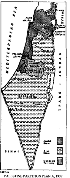
Peel partition - plan A, This image was included in the League of Nations document C.495.M.336.1937.VI. Geneva, November 30th, 1937 | ||
|---|---|---|---|
| Source |
Source: [1] | ||
| Date | |||
| Author |
| ||
| Permission (Reusing this file) |
See below.
|
Licensing
[edit]| This file is in the public domain, because This image was included in the League of Nations document C.495.M.336.1937.VI. Geneva, November 30th, 1937
Please verify that the reason given above is valid! Note: if there is a specific licence tag for the reason supplied here, please use it. |
File history
Click on a date/time to view the file as it appeared at that time.
| Date/Time | Thumbnail | Dimensions | User | Comment | |
|---|---|---|---|---|---|
| current | 07:28, 28 September 2004 | 344 × 872 (12 KB) | Humus sapiens (talk | contribs) | Peel partition - plan A |
You cannot overwrite this file.
File usage
The following 3 pages use this file:
