Monte d'Accoddi
40°47′28″N 8°26′56″E / 40.79111°N 8.44889°E
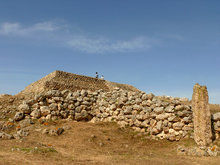
 View from the base of Monte d'Accoddi | |
| Lua error in Module:Location_map at line 526: Unable to find the specified location map definition: "Module:Location map/data/Italy Sardegna" does not exist. | |
| Type | Monument |
|---|---|
| History | |
| Cultures | Nuragic civilization |
| Site notes | |
| Excavation dates | yes |
| Condition | ruined |
| Management | I Beni Culturali della Sardegna |
| Public access | yes |
| Website | Sassari, Tempio-altare di Monte d'Accoddi Template:It icon |
Monte d'Accoddi is an archaeological site in northern Sardinia, Italy, located in the territory of Sassari near Porto Torres.
It is the site of a Chalcolithic structure of the Ozieri culture, the oldest parts are dated to around c. 4,000-3,650 BC[1][2] and discovered in 1954, in a field owned by Segni family. The structure has a base of 27 m by 27 m and probably reached a height of 5.5 m. It culminated in a platform of about 12.5 m by 7.2 m, accessible via a ramp. It has been variously described as an altar, a mound, a temple or a step pyramid.[3] As there have never been found any chambers or entrances to the mound, it is presumed to have been either an altar or to have served an observational function, as its square plan is coordinated with the cardinal points of the compass.[4]
Surrounding Area
The surroundings of the Monte d'Accoddi have been excavated in the 1960s, and have provided the signs of a considerable sacred center. Near the south-eastern corner of the monument there is a dolmen, and across the ramp stands a considerable menhir, one of several standing stones which was formerly found in the vicinity. The foundations of several small structures (possibly residential) were excavated, and several mysterious carved stones. The most impressive of these is a large boulder carved into the shape of an egg and then cut through on a subtle curving three-dimensional line.[4]
Reconstruction
It has been partially reconstructed during the 1980s. It is open to the public and accessible by the old route of SS131 highway, near the hamlet of Ottava.
-
Monte d'Accoddi
-
Prehistoric temple of Monte d'Accoddi, showing the dolmen and egg-shaped carved boulder.
Sources
- Ercole Contu, Monte d´Accoddi (Sassari). Problematiche di studio e di ricerca di un singolare monumento preistorico, Oxford 1984.
- S. Tinè, S. Bafico, T. Mannoni, 'Monte d'Accoddi e la Cultura di Ozieri', in La Cultura di Ozieri: problematiche e nuove acquisizioni, Ozieri 1989, pp. 19–36.
- Ercole Contu, "L'altare preistorico di Monte d'Accoddi" Sardegna Digital Library
References
- ^ Ercole Contu. "L'altare preistorico di Monte d'Acoddi" (PDF). Sardegnacultura.it. p. 14. Retrieved 2015-04-25.
- ^ "Monte d'Accoddi and the end of the Neolithic in Sardinia (Italy)" (PDF). Arheologija.ff.uni.lj.si. Retrieved 2015-04-25.
- ^ Ercole Contu (2000). L'altare preistorico di Monte d'Accoddi. C. Delfino. ISBN 978-88-7138-206-7.
- ^ a b A. Sinclair & J. Bradbury; Megaliths and their Mysteries; 1979; pp. 109-112; ISBN 0-02-609730-3


