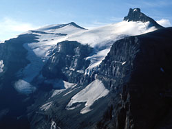
Resolute Mountain
Appearance
This article, Resolute Mountain, has recently been created via the Articles for creation process. Please check to see if the reviewer has accidentally left this template after accepting the draft and take appropriate action as necessary.
Reviewer tools: Inform author |
| Resolute Mountain | |
|---|---|
 | |
| Highest point | |
| Elevation | 3,150 m (10,330 ft) |
| Prominence | 395 m (1,296 ft) |
| Coordinates | 52°4′24″N 116°39′34″W / 52.07333°N 116.65944°W |
| Geography | |
| Location | Alberta, Canada |
| Parent range | Cline Range[1] |
| Topo map | NTS 83C/02 |
Resolute mountain is located in David Thompson Country, western Alberta, Canada, 12 km north of Saskatchewan River Crossing. Its line parent is Mount Cline located 2 kilometers to the east.[2][3]
Resolute has two main peaks, Lion and Lioness, both are about 3150m high. Both peaks are glaciated on their northern slopes.[4] Resolute was first ascended in 1958 by A. Hober and E. Hopkins. The easiest route up resolute is accessible from Alberta Highway 11, where it crosses Thompson creek.[5]
References
- ^ "Cline Range". Peakbagger.com. Retrieved 2017-08-12.
- ^ "Environmentally Significant Areas Inventory of the Rocky Mountain Natural Region of Alberta" (PDF). p. 36.
{{cite web}}: Cite has empty unknown parameter:|dead-url=(help) - ^ "Resolute Mountain". peakery.com. Retrieved 2017-08-13.
- ^ "Peaks of the Canadian Rockies". peakfinder.com. Retrieved 2017-08-13.
- ^ Ross, Jane; Kyba, Daniel (2016-03-02). The David Thompson Highway Hiking Guide – 2nd Edition. Rocky Mountain Books Ltd. ISBN 9781771600910.
This article, Resolute Mountain, has recently been created via the Articles for creation process. Please check to see if the reviewer has accidentally left this template after accepting the draft and take appropriate action as necessary.
Reviewer tools: Inform author |


