User:Nrcimochowski/sandbox
Appearance
Tolland County | |
|---|---|
 | |
 Location within the U.S. state of Connecticut | |
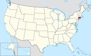
 Connecticut's location within the U.S. | |
| Country | |
| State | |
| Founded | 1785 |
| Seat | none (since 1960) Tolland (1785-1889) Rockville (1889-1960) |
| Largest town | Vernon |
| Area | |
| • Total | 417 sq mi (1,080 km2) |
| • Land | 410 sq mi (1,100 km2) |
| • Water | 6.8 sq mi (18 km2) 1.6% |
| Population | |
| • Estimate (2016) | 151,118 |
| • Density | 372/sq mi (144/km2) |
| Time zone | UTC−5 (Eastern) |
| • Summer (DST) | UTC−4 (EDT) |
| Congressional district | 2nd |
- ^ "Highest and Lowest Elevations". Elevations and Distances in the United States. United States Geological Survey. 2001. Archived from the original on November 9, 2013. Retrieved October 25, 2015.
{{cite web}}: Unknown parameter|deadurl=ignored (|url-status=suggested) (help) - ^ Elevation adjusted to North American Vertical Datum of 1988.
