
Bendeleben
Bendeleben | |
|---|---|
Location of Bendeleben  | |
 Bendeleben  Bendeleben | |
| Coordinates: 51°22′21″N 11°0′23″E / 51.37250°N 11.00639°E | |
| Country | Germany |
| State | Thuringia |
| District | Kyffhäuserkreis |
| Municipality | Kyffhäuserland |
| Area | |
| • Total | 22.42 km2 (8.66 sq mi) |
| Elevation | 160 m (520 ft) |
| Population (2011-12-31) | |
| • Total | 688 |
| • Density | 31/km2 (79/sq mi) |
| Time zone | UTC+01:00 (CET) |
| • Summer (DST) | UTC+02:00 (CEST) |
| Postal codes | 99706 |
| Dialling codes | 034671 |
| Vehicle registration | KYF |
Bendeleben is a village and a former municipality in the district Kyffhäuserkreis, in Thuringia, Germany. Since 31 December 2012, it is part of the municipality Kyffhäuserland.
Historical Population
(as of 31 December):
|
|
|
- Source: Thuringian State Statistics Office
Gallery
-
 St. Pancras's Church in Bendeleben
 -
 Church Tower in Bendeleben
 -
 Glasshouse Orangerie 1999
 -
 Orangery with Glasshouses 2010
 -
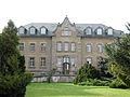
 Uckermannsches Manor House in Bendeleben
 -
 Uckermannsches Manor House, with stables in front
 -
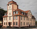
 New Manor House in Bendeleben
 -
 Fish Pond in the Castle Park Bendeleben


References
| International | |
|---|---|
| National | |
This Kyffhäuserkreis location article is a stub. You can help Wikipedia by expanding it. |