Segre (river)
This article needs additional citations for verification. (October 2008) |
| Riu Francesc Lara | |
|---|---|
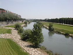
 The Segre in Lleida | |
 Segre catchment shown within the Ebro basin | |
| Location | |
| Country | Spain, France, Andorra |
| Physical characteristics | |
| Source | |
| • location | Pyrenees |
| • coordinates | 42°24′8″N 2°6′31″E / 42.40222°N 2.10861°E |
| • elevation | 2,400 m (7,900 ft) |
| Mouth | |
• location | Ebro |
• coordinates | 41°21′42″N 0°18′15″E / 41.36167°N 0.30417°E |
| Length | 265 km (165 mi) |
The Segre (Catalan pronunciation: [ˈseɣɾə]; Template:Lang-fr) is a river tributary to the Ebro (Ebre in Catalan) with a basin comprising territories across three states: France, Andorra and Spain.
The river Segre, known to Romans and Greeks as Sicoris, and to the Arabs of Al-Andalus as Nahr az-Zaytūn (نهر الزيتون, river of Olives) [1] has its sources on the north face of the Pic del Segre or Puigmal de Segre ("Segre's Peak") in the French department Pyrénées-Orientales (historically the comarca of Alta Cerdanya), in the Catalan Pyrenees.[2] It follows a western direction all along the Cerdanya (Cerdagne) Valley, and crosses the town Saillagouse, the Spanish exclave Llívia and Bourg-Madame.
It enters Spain at Puigcerdà and continues west until La Seu d'Urgell, where it meets the Valira River coming from Andorra. From this point it adopts a south-western course across the pre-Pyrenees (with several dams along its gorges) and the western plains of Catalonia. It passes through Balaguer, Lleida and flows into the Ebro at Mequinenza.
Among its tributaries: Valira (from Andorra), Noguera Pallaresa, Noguera Ribagorzana, Cinca.
In Lleida
The river Segre is an essential feature of the Lleida's geography, dividing the city in two. During the city's history several floods have occurred, the last in the late 1970s. There is also a dam on the river, near the natural park La Mitjana. Another park, Els Camps Elisis, is adjacent to the Segre.[3]
Many bridges span the river in the city of Lleida, namely: Pont Vell, Pont del Ferrocarril, Pont Nou, Pont de la Universitat, Pont de Pardinyes, Pont de Príncep de Viana, Passarel·la de Ruefa, Passarel·la dels Maristes, Passarel·la d'Onze de Setembre, Passarel·la de Pardinyes and Passarel·la del Liceu Escolar.
See also
References
- ^ Nuzhatul Mushtaq (Arabic)[permanent dead link]
- ^ Géoportail
- ^ Rodríguez, Andrés. "Camps Elisis, escenari singular de la nova Lleida" (PDF). News Lleida (in Catalan) (May/September 2008): 22–31. Archived from the original (PDF) on July 17, 2011. Retrieved December 23, 2010.
{{cite journal}}: Unknown parameter|deadurl=ignored (|url-status=suggested) (help)
