
Search results
The page "Datum level" does not exist. You can create a draft and submit it for review or request that a redirect be created, but consider checking the search results below to see whether the topic is already covered.
 global MSL is a type of vertical datum – a standardised geodetic datum – that is used, for example, as a chart datum in cartography and marine navigation...23 KB (4,104 words) - 03:03, 16 July 2024
 A chart datum is the water level surface serving as origin of depths displayed on a nautical chart and for reporting and predicting tide heights. A chart...10 KB (1,156 words) - 00:08, 23 July 2024
 vertical datum is used to measure the elevation or depth relative to a standard origin, such as mean sea level (MSL). A three-dimensional datum enables...31 KB (3,346 words) - 06:28, 11 August 2024
 North American Datum of 1988. It superseded the National Geodetic Vertical Datum of 1929 (NGVD 29), previously known as the Sea Level Datum of 1929. NAVD...7 KB (732 words) - 16:18, 31 January 2024
 datum (AOD). Usually mean sea level (MSL) at a particular place is used for the datum. In Great Britain, OD for the Ordnance Survey is Ordnance Datum...7 KB (777 words) - 06:44, 24 August 2024
- bathymetry, water level, and built structures) and altitudes of satellite orbits and in aviation. In planetary science, vertical datums are also known as...10 KB (1,459 words) - 03:47, 10 July 2024
- above mean sea level is a measure of a location's vertical distance (height, elevation or altitude) in reference to a vertical datum based on a historic...6 KB (700 words) - 00:08, 23 July 2024
- of America by the General Adjustment of 1929. Originally known as Sea Level Datum of 1929, NGVD 29 was determined and published by the United States Coast...4 KB (397 words) - 01:26, 19 November 2023
- single item of data. Geodetic datum, a standard position or level that measurements are taken from in geographic surveying Datum reference, in carpentry, metalworking...960 bytes (162 words) - 12:01, 12 December 2023
 measurements are referred. The Australian Height Datum is an amalgamation of decades of spirit levelling work conducted by numerous state and territory...20 KB (2,271 words) - 01:26, 1 July 2024
- In surveying, reduced level (RL) refers to equating elevations of survey points with reference to a common assumed vertical datum. It is a vertical distance...4 KB (457 words) - 06:02, 23 May 2024
 NAP markers in Amsterdam Amsterdam Ordnance Datum or Normaal Amsterdams Peil (NAP) is a vertical datum in use in large parts of Western Europe. Originally...4 KB (552 words) - 09:12, 16 June 2024
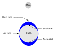 Tide (section Reference levels)water level over time. Gauges ignore variations caused by waves with periods shorter than minutes. These data are compared to the reference (or datum) level...109 KB (13,080 words) - 01:26, 22 August 2024
 Plumb bob (redirect from Plumb bob level)line, or plumb-line. It is a precursor to the spirit level and used to establish a vertical datum. It is typically made of stone, wood, or lead, but can...6 KB (624 words) - 00:11, 7 February 2024
 The North American Datum (NAD) is the horizontal datum now used to define the geodetic network in North America. A datum is a formal description of the...13 KB (1,613 words) - 18:25, 12 August 2024
 Geographic coordinate system (section Geodetic datum)standards, also includes a choice of geodetic datum (including an Earth ellipsoid), as different datums will yield different latitude and longitude values...22 KB (2,491 words) - 18:21, 12 August 2024
- the large geodetic systems, such as European Datum (ED50), North American Datum (NAD), and Tokyo Datum (TD), to provide a worldwide geo-data basis Need...24 KB (2,843 words) - 13:42, 3 August 2024
 points relative to a datum. It is widely used in geodesy and cartography to measure vertical position with respect to a vertical datum, and in construction...15 KB (2,175 words) - 06:26, 10 August 2024
 scarce up to the 1970s. The longest running sea-level measurements, NAP or Amsterdam Ordnance Datum were established in 1675, in Amsterdam. Record collection...207 KB (21,870 words) - 17:41, 22 August 2024
 They're asking two- and three-inch-diameter steel tubes at chassis base datum level to do all the work, and it shows – you can feel the chassis flexing on...41 KB (4,189 words) - 19:05, 16 August 2024


- navigation, two general types of datums must be considered: horizontal datum and vertical datum. The horizontal datum forms the basis for computations
- contemptu m[ortis incitamentum] ad uincendum homini ab dis immortalibus acrius datum est. God has given to man no sharper spur to victory than contempt of death
- regions and countries of the world about the challenges of tying their datums to global coordinate reference systems. As the final product will be incorporated