
Search results
The page "Solway Estuary" does not exist. You can create a draft and submit it for review or request that a redirect be created, but consider checking the search results below to see whether the topic is already covered.
 Whithorn (which is actually a peninsula). The Islands of Fleet The Solway Firth is the estuary of the River Eden and the River Esk. Below are links to lists...12 KB (1,245 words) - 15:12, 26 June 2024
 Britain starting north/east of the A5, west of the A6, south of the Solway Firth/Eden Estuary (roads beginning with 5). "A506 - Roader's Digest: The SABRE Wiki"...53 KB (46 words) - 15:44, 8 July 2024
 Bowness-on-Solway is a village in Cumbria, England. It is situated to the west of Carlisle on the southern side of the Solway Firth estuary separating...7 KB (627 words) - 15:43, 1 July 2023
- Estuary Fal Estuary Fowey Estuary Gannel Estuary Hamford Water Hayle Estuary Helford Estuary Humber Estuary Inner Solway Estuary Inner Thames Estuary...2 KB (221 words) - 14:53, 1 November 2023
 Humber Oder Estuary Severn Estuary Shannon Estuary Solway Firth Southampton Water Tagus Estuary Thames Estuary The Wash Unterelbe Western Scheldt Albemarle...41 KB (4,819 words) - 06:41, 4 July 2024
 River Nith (redirect from Nith Estuary National Scenic Area)south-easterly direction through Dumfries and Galloway and then into the Solway Firth at Airds Point. The territory through which the river flows is called...8 KB (663 words) - 18:52, 4 May 2023
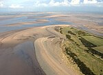 at the estuary of the rivers Esk and Eden, in a westerly direction as far as Silloth-on-Solway, including the villages of Bowness-on-Solway, Burgh-by-Sands...8 KB (750 words) - 22:04, 16 June 2023
- Firth (category Estuaries of Scotland)pronunciation: [ə ˈʎiɲə ˈɣl̪ˠas̪]. Solway Firth (inlet with the rivers Eden, Esk and Nith). The Firth is off the Solway Coast. Rough Firth Places: Carlisle...12 KB (1,299 words) - 16:33, 11 July 2024
 A roads in the zone 7 in Great Britain starting north of the Solway Firth/Eden Estuary, west of the A7 and south of the A8 (roads beginning with 7)....19 KB (100 words) - 15:44, 8 July 2024
 west the county is bounded by the Solway Firth and the Irish Sea. The northern boundary is formed by the Solway Estuary and the border with Scotland running...35 KB (2,174 words) - 06:34, 30 June 2024
 with many small yachts moored in the tidal estuary of the River Urr, and events organised by the Solway Yacht Club. The RNLI has maintained a station...4 KB (358 words) - 18:27, 17 August 2023
 crossing the border to the English county of Cumbria and flowing into the Solway Firth. The river rises in the hills to the east of Moffat and its two main...4 KB (596 words) - 10:35, 1 May 2024
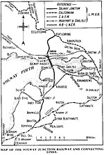 The Solway Junction Railway was built by an independent railway company to shorten the route from ironstone mines in Cumberland to ironworks in Lanarkshire...45 KB (5,743 words) - 20:17, 17 July 2024
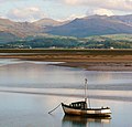 (35 km2), making it the second largest estuary in Cumbria after the Solway Firth and one of the six main estuaries in the historic county of Lancashire...6 KB (538 words) - 19:24, 15 February 2024
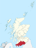 areas within this region. Nith Estuary: this area follows the River Nith southward from just south of Dumfries into the Solway Firth. Dumfries itself has...47 KB (3,537 words) - 14:50, 16 June 2024
 estuary of the Solway upon an iron girder viaduct, one mile 176 yards in length. The local people's frustration at the delay in reopening the Solway Viaduct...5 KB (511 words) - 08:23, 17 April 2024
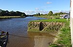 heard before it is seen. The shallow Nith flows into the wide, flat Solway estuary and when conditions are right, as with high spring tides and with favourable...13 KB (1,460 words) - 11:34, 28 October 2023
 Estuary Lough Foyle Luce Bay Lyme Bay Mersey Estuary Moray Firth Morecambe Bay Poole Harbour Solway Firth Strangford Lough Swansea Bay Thames Estuary...8 KB (828 words) - 17:14, 28 June 2024
 the estuary of the Border Esk at the eastern limit of the Solway Firth. Ordnance Survey 1:50,000 scale Landranger map sheet 85 Carlisle and Solway Firth...1 KB (145 words) - 12:58, 11 April 2022
 heard before it is seen. The shallow Nith flows into the wide, flat Solway estuary and when conditions are right, as with high spring tides and with favourable...9 KB (1,080 words) - 23:45, 13 January 2024


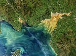
- Encyclopædia Britannica, Volume 25 Solway Firth 26315821911 Encyclopædia Britannica, Volume 25 — Solway Firth SOLWAY FIRTH, an estuarine inlet of the Irish