
Search results
 [[File:Ordnance Survey 1-250000 - TF.jpg|thumb|Grid square TF. The map shows [[The Wash]] and the [[North Sea]], as well as places within the counties of [[Lincolnshire]]...19 KB (2,130 words) - 10:22, 14 April 2024
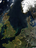 and Denmark and low-lying areas of eastern England particularly around [[The Wash]] and [[The Fens|Fens]].<ref name="GHC"/> Storm surges are caused by changes...135 KB (11,996 words) - 20:12, 16 May 2024
 Coastline forms the sea boundary and border with [[Norfolk]] at the [[The Wash|Wash]]. The coast then at [[Boston, Lincolnshire|Boston]] becomes the...91 KB (8,839 words) - 11:53, 8 May 2024
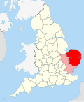 On the north-west corner East Anglia is bordered by a bay known as [[The Wash]], where owing to deposits of sediment and [[land reclamation]], the coastline...29 KB (3,134 words) - 08:07, 14 May 2024
 [[East of England]] and [[East Anglia]]. It borders [[Lincolnshire]] and [[The Wash]] to the north-west, the [[North Sea]] to the north and east, [[Cambridgeshire]]...80 KB (8,491 words) - 17:08, 8 May 2024
 contains the [[Drainage divide|watershed]] between the [[River Severn]] and [[The Wash]], and several important rivers have their sources in the north-west of...82 KB (7,587 words) - 14:07, 10 May 2024
 areas include [[Exmoor]], the [[Lake District]], the [[Pennines]], and [[The Wash]].<ref>{{cite journal |last1=Fair |first1=James |title=Concern for sites...20 KB (2,574 words) - 16:37, 10 May 2024
 [[Humber]] * [[Severn Estuary]] * [[Shannon Estuary]] * [[Thames Estuary]] * [[The Wash]] * [[Unterelbe]] * [[Western Scheldt]] * [[Tagus Estuary]] * [[Oder]]...41 KB (4,795 words) - 12:58, 5 May 2024
 Forest]] *[[Rutland]], SW [[Lincolnshire]] and N [[Northamptonshire]] *[[The Wash]] [[File:Image-Major Oak in Sherwood Forest in 2006 (2).jpg|thumb|220px|[[Major...139 KB (13,823 words) - 14:28, 13 May 2024
 had been either lost or sold during the civil war or possibly lost in [[The Wash#King John and his jewels|The Wash]], so instead the ceremony used a simple...133 KB (17,196 words) - 07:22, 15 May 2024
 {{Convert|74|mi|km}} north of London, on the [[River Nene]] which flows into [[The Wash]] {{Convert|27|mi|km}} to the north-east; the [[City status in the United...168 KB (16,085 words) - 15:59, 16 May 2024
 Shore are two nature reserves, managed by the [[RSPB]], which lie on [[The Wash]] coast on either side of the mouth of The Haven.<ref>{{Cite web |url=https://www...70 KB (7,940 words) - 08:16, 20 May 2024
 |isbn=0-319-21867-8}}</ref> The town lies about {{convert|5|mi|km|0}} south of the [[The Wash|Wash]], a fourfold [[estuary]] subject to dangerous tides and shifting...75 KB (8,121 words) - 19:35, 29 April 2024
 line. The original Skegness was situated farther east at the mouth of [[The Wash]]. Its [[Old Norse|Norse]] name refers to a [[headland]] which sat near...200 KB (19,355 words) - 09:13, 10 May 2024
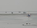 <ref>{{cite web|title=The Hermitage|url={{sssi link|1003104}}}}</ref> |- | [[The Wash]] | align="center"|{{y}} | | align="right"|62,045.8 | align="right"|153...42 KB (645 words) - 17:38, 9 March 2024
- seven people were injured for no material damage. L13 made landfall at [[The Wash]] and flew straight to London in clear skies, bombing [[Golders Green]]...84 KB (12,469 words) - 08:45, 18 May 2024
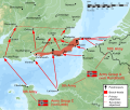 ''Luftwaffe''. The paper outlined an assault on England's eastern coast between [[The Wash]] and the [[River Thames]] by troops crossing the [[North Sea]] from ports...126 KB (17,346 words) - 14:55, 18 May 2024
 | source1_elevation = {{cvt|150|m}} | mouth = [[The Wash]] | mouth_location = [[King's Lynn]], [[United Kingdom]] | mouth_coordinates...38 KB (4,758 words) - 13:06, 16 May 2024
- {{IPA|[ɑː]}} in many words crosses England from mid-[[Shropshire]] to [[The Wash]], passing just south of [[Birmingham]]. * Additionally, just like the...58 KB (7,120 words) - 21:13, 2 May 2024
- Lincolnshire|Boston]] and [[Spalding, Lincolnshire|Spalding]] and extending around [[The Wash]] to the county border with Norfolk. ** The [[River Witham|Witham Valley]]...4 KB (519 words) - 11:35, 7 November 2023


