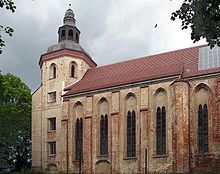
Commandry of Mirow

The Commandry of Mirow was a commandry of the Knights Hospitaller, based in Mirow, a town in Mecklenburg-Vorpommern. It existed from 1226 until 1648.
External links[edit]
53°16′36″N 12°48′35″E / 53.2767°N 12.8097°E
This is the current revision of this page, as edited by Tom.Reding (talk | contribs) at 14:59, 19 November 2023 (+{{Authority control}} (1 ID from Wikidata); WP:GenFixes & cleanup on). The present address (URL) is a permanent link to this version.
This article does not cite any sources. Please help improve this article by adding citations to reliable sources. Unsourced material may be challenged and removed. Find sources: "Commandry of Mirow" – news · newspapers · books · scholar · JSTOR (March 2015) (Learn how and when to remove this message) |

The Commandry of Mirow was a commandry of the Knights Hospitaller, based in Mirow, a town in Mecklenburg-Vorpommern. It existed from 1226 until 1648.
| Authority control databases: Geographic |
|---|
53°16′36″N 12°48′35″E / 53.2767°N 12.8097°E / 53.2767; 12.8097
This German history article is a stub. You can help Wikipedia by expanding it. |