Jump to content

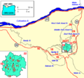
File:Map mount hood vicinity.png

Page contents not supported in other languages.
This is a file from the Wikimedia Commons
From Wikipedia, the free encyclopedia

Map_mount_hood_vicinity.png (564 × 526 pixels, file size: 13 KB, MIME type: image/png)

Key

  1. Crater Rock
  2. Coalman Glacier
  3. Steel Cliff
  4. Illumination Ridge
  5. Zigzag Glacier
  6. Reid Glacier
  7. Sandy Glacier
  8. Ladd Glacier
  9. Coe Glacier
  10. Eliot Glacier
  11. Newton-Clark Glacier
  12. White River Glacier
  13. Timberline Lodge
  14. Laurel Hill
  15. Tom Dick and Harry Mountain
  16. Brightwood
  17. Zigzag
  18. Zigzag Mountain
  19. Sandy Glacier Volcano
  20. Vista Ridge
  21. The Pinnacle
  22. Cloud Cap Inn
  23. Polallie Creek
  24. Parkdale
  25. Upper Valley
  26. Dee Flat
  27. Hood River

Summary

Description
English: map of Mount Hood's glaciers and rivers
Converted image format from .gif to .png 2006-8-9 using photoshop CS2 (9.0.1)
Date 1989, 1997
Source http://vulcan.wr.usgs.gov/Volcanoes/PacificNW/AGU-T106/hood.html
Author U.S. Geological Survey
Permission
(Reusing this file)
PD-USGOV-INTERIOR-USGS

Licensing

Public domain
This image is in the public domain in the United States because it only contains materials that originally came from the United States Geological Survey, an agency of the United States Department of the Interior. For more information, see the official USGS copyright policy.

Bahasa Indonesia  català  čeština  Deutsch  eesti  English  español  français  galego  italiano  Nederlands  português  polski  sicilianu  suomi  Tiếng Việt  Türkçe  български  македонски  русский  മലയാളം  한국어  日本語  中文  中文(简体)  中文(繁體)  العربية  فارسی  +/−

Original upload log

Transferred from en.wikipedia to Commons by Jsayre64 using CommonsHelper.

The original description page was here. All following user names refer to en.wikipedia.
  • 2007-12-23 03:18 Peteforsyth 564×526× (13591 bytes) crop out and textify/wikify key
  • 2007-10-20 22:24 Peteforsyth 813×528× (19922 bytes) crop unnecessary text
  • 2006-08-09 07:29 EncMstr 837×625× (25005 bytes) {{Information |Description=map of [[Mount Hood]]'s glaciers and rivers |Source=http://vulcan.wr.usgs.gov/Volcanoes/Hood/Maps/map_hood_vicinity.html |Date=1997, 1986 |Author=[[USGS]] }} Converted image format from .gif to .png 2006-8-9 using photoshop CS2

Captions

Add a one-line explanation of what this file represents

Items portrayed in this file

depicts

File history

Click on a date/time to view the file as it appeared at that time.

Date/TimeThumbnailDimensionsUserComment
current20:21, 1 July 2013Thumbnail for version as of 20:21, 1 July 2013564 × 526 (13 KB)PeteforsythThe previous file was only uploaded to show the file's history. Reverted to version as of 19:35, 1 July 2013
20:20, 1 July 2013Thumbnail for version as of 20:20, 1 July 2013837 × 625 (24 KB)PeteforsythUpload temporarily so that the revision history contains the original version, as uploaded to English Wikipedia by EncMstr on August 9, 2006.
19:35, 1 July 2013Thumbnail for version as of 19:35, 1 July 2013564 × 526 (13 KB)File Upload Bot (Magnus Manske)Transfered from en.wikipedia by User:Jsayre64 using CommonsHelper

Metadata