
File:Central Asia (orthographic projection).svg

Size of this PNG preview of this SVG file: 553 × 553 pixels. Other resolutions: 240 × 240 pixels | 480 × 480 pixels | 768 × 768 pixels | 1,024 × 1,024 pixels | 2,048 × 2,048 pixels.
Original file (SVG file, nominally 553 × 553 pixels, file size: 344 KB)
| This is a file from the Wikimedia Commons. Information from its description page there is shown below. Commons is a freely licensed media file repository. You can help. |
Summary
| Description |
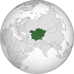
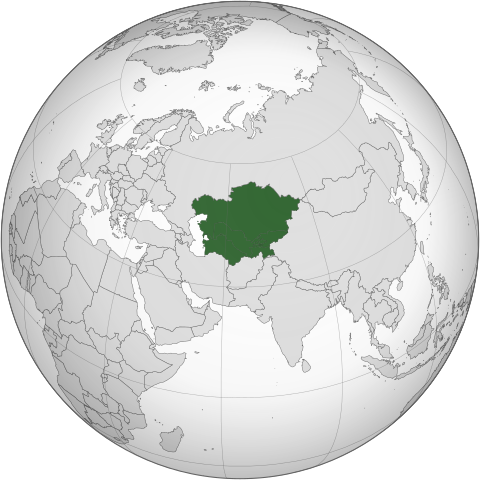
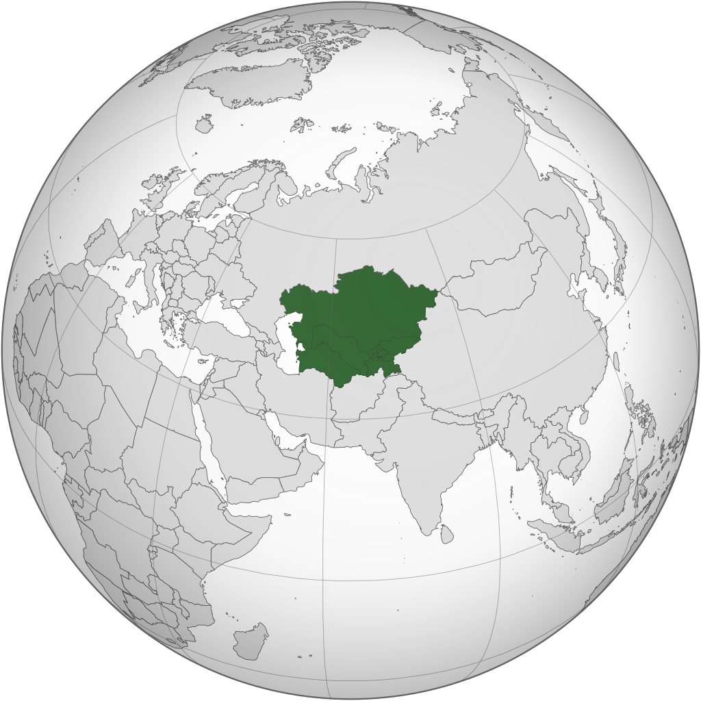
English: Central Asia with national borders Español: Asia Central con bordes |
| Date | |
| Source | Iran (orthographic projection).svg |
| Author | Serg!o |
| Other versions |
.svg) |
| SVG development |
.svg)
.svg)
.svg)
.svg)
.svg)
.svg)
.svg)
.svg)
.svg)
.svg)
.svg)
.svg)
.svg)
.svg)
.svg)
.svg)
.svg)
.svg)
.svg)
.svg)
.svg)
.svg)
.svg)
.svg)
.svg)
.svg)
.svg)
.svg)
.svg)
.svg)
.svg)
.svg)
.svg)
.svg)
.svg)
.svg)
.svg)
.svg)
.svg)
.svg)
.svg)
.svg)
.svg)
.svg)
.svg)
.svg)
.svg)
.svg)
.svg)
.svg)
.svg)
.svg)
.svg)
.svg)
.svg)
.svg)
.svg)
.svg)
.svg)
.svg)
.svg)
.svg)
.svg)
.svg)
.svg)
.svg)
.svg)
.svg)
.svg)
.svg)
.svg)
.svg)
.svg)

.svg)

.svg)

.svg)
.svg)
.svg)
.svg)
.svg)
.svg)
.svg)


.svg)
.svg)
.svg)
.svg)
.svg)
.svg)
.svg)

.svg)
.svg)
.svg)
.svg)
.svg)
.svg)
.svg)
.svg)
.svg)
.svg)

.svg)
.svg)
.svg)
.svg)
.svg)
.svg)
.svg)
_without_national_boundaries.svg)
.svg)
.svg)
.svg)
.svg)
.svg)
.svg)

.svg)
.svg)
.png)
.svg)
.svg)
.svg)
.svg)

.svg)
.svg)
.svg)
.svg)
.svg)
.svg)
.svg)
.svg)
.svg)
.svg)
.svg)

.svg)
.svg)
.svg)
.svg)
.svg)
.svg)
.svg)
.svg)
.svg)

.svg)
.svg)

.svg)
.svg)
.svg)
.svg)
.svg)
.svg)
.svg)
.svg)
.svg)
.svg)
.svg)
.svg)
.svg)
.svg)
.svg)
.svg)
.svg)
.svg)
.svg)
.svg)
.svg)
.svg)
.svg)
.svg)
.svg)
.svg)
.svg)
_-_Crimea_disputed.svg)
.svg)
.svg)
.svg)
.svg)
.svg)
.svg)
.svg)
.svg)
.svg)
.svg)
.svg)
_political.svg)
.svg)
.svg)
.svg)
.svg)
_-_Crimea_disputed_-_no_borders.svg)
.svg)
.svg)
.svg)
.svg)
.svg)
.svg)
.svg)
.svg)
.svg)
.svg)
.svg)

.svg)
.svg)
.svg)

.png)
.svg)
.svg)
.svg)
.svg)
.svg)
.svg)
.svg)
.svg)
.svg)
.svg)
.svg)
.svg)
.svg)
.svg)
.svg)
.svg)
.svg)
.svg)
.svg)
.svg)
.svg)
.svg)
.svg)
.svg)
.svg)
.svg)
.svg)
.svg)
.svg)
.svg)
.svg)
.svg)
.svg)
.svg)
.png)
.svg)
.svg)
.svg)
_(orthographic_projection).png)
.svg)
Licensing
I, the copyright holder of this work, hereby publish it under the following licenses:
This file is licensed under the Creative Commons Attribution-Share Alike 3.0 Unported license.
- You are free:
- to share – to copy, distribute and transmit the work
- to remix – to adapt the work
- Under the following conditions:
- attribution – You must give appropriate credit, provide a link to the license, and indicate if changes were made. You may do so in any reasonable manner, but not in any way that suggests the licensor endorses you or your use.
- share alike – If you remix, transform, or build upon the material, you must distribute your contributions under the same or compatible license as the original.

|
Permission is granted to copy, distribute and/or modify this document under the terms of the GNU Free Documentation License, Version 1.2 or any later version published by the Free Software Foundation; with no Invariant Sections, no Front-Cover Texts, and no Back-Cover Texts. A copy of the license is included in the section entitled GNU Free Documentation License. |
You may select the license of your choice.
File history
Click on a date/time to view the file as it appeared at that time.
.svg)
.svg&dir=prev&offset=20091127103547)
.svg&offset=20130804183708&limit=20)
.svg&offset=20130804183708&limit=50)
.svg&offset=20130804183708&limit=100)
.svg&offset=20130804183708&limit=250)
.svg&offset=20130804183708&limit=500)
| Date/Time | Thumbnail | Dimensions | User | Comment | |
|---|---|---|---|---|---|
| 10:35, 27 November 2009 |  | 541 × 541 (849 KB) | Serg!o | {{Information |Description={{en|1=Central Asia}} {{es|Asia Central}} {{fa|1=ایران}} |Source=File:Iran (orthographic projection).svg<br /> {{Inkscape}} |Author=user:Serg!o |Date=2009-11 |Permission=See below. |other_versions={ |
.svg)
File usage
The following pages on the English Wikipedia use this file (pages on other projects are not listed):
- Architecture of Central Asia
- Asian cuisine
- Bibliography of the history of Central Asia
- Central Asia
- Greater Central Asia
- List of Asian cuisines
- List of sex worker organizations
- Russian conquest of Central Asia
- Soviet Central Asia
- User:Abc918273/sandbox
- User:Biktor627
- User:Biktor627/Badges
- User:Buaidh/Test4
- User:CountryUniverse
- User:FlyingScotsman72
- User:Gabriel سلیمی
- User:Hatchens
- User:HugoOfTheWorld
- User:Irtapil/Interesting Projects
- User:Malik Nursultan B
- User:Phaisit16207/sandbox/Russian conquest of Central Asia
- User:Sam Walczak
- User:Your Friendly Neighborhood Sociologist
- User:Ziraro
- User:좀비 브렌다
- Wikipedia:Graphics Lab/Map workshop/Archive/Apr 2020
- Wikipedia:Userboxes/Location/Asia
- Wikipedia:Userboxes/Location/Asia/Regions
- Wikipedia:Userboxes/WikiProjects/Regional/03
- Wikipedia:Userboxes/WikiProjects/alphabetical/06
- Wikipedia:WikiProject Central Asia/Participants
- Template:Central Asian topics
- Template:User Central Asian ancestry
- Template:User Central Asian ancestry/doc
- Template:User WP Central Asia
- Template:User WP Central Asia/doc
- Template:User from Central Asia
- Template:User from Central Asia/doc
- Template:User from Central Asia/doc1
- Template:User in Central Asia
- Template:User in Central Asia/doc
- Template:User interest Central Asia
- Template:User interest Central Asia/doc
- Template:User proud Central Asian
- Template:User proud Central Asian/doc
- Template talk:Countries of Asia
- Category:Central Asian Wikipedians
- Category:WikiProject Central Asia participants
- Category:Wikipedians in Central Asia
- Category:Wikipedians interested in Central Asia
- Portal:Asia/Central Asia
- Portal:Asia/Map of Central Asia
Global file usage
The following other wikis use this file:
- Usage on af.wikipedia.org
- Usage on ar.wikipedia.org
- Usage on arz.wikipedia.org
- Usage on az.wikipedia.org
- Usage on ba.wikipedia.org
- Usage on bg.wikipedia.org
- Usage on bh.wikipedia.org
- Usage on bn.wikipedia.org
- Usage on bs.wikipedia.org
- Usage on cdo.wikipedia.org
- Usage on ckb.wikipedia.org
- Usage on cs.wikipedia.org
- Usage on de.wikipedia.org
- Usage on el.wikipedia.org
- Usage on el.wiktionary.org
- Usage on en.wiktionary.org
- Usage on eo.wikiquote.org
- Usage on es.wikipedia.org
- Usage on et.wikipedia.org
- Usage on eu.wikipedia.org
- Usage on fa.wikipedia.org
- Usage on fi.wikipedia.org
- Usage on frr.wikipedia.org
- Usage on fr.wikipedia.org
- Usage on fr.wiktionary.org
- Usage on gn.wikipedia.org
- Usage on he.wikipedia.org
- Usage on hu.wikipedia.org
View more global usage of this file.
.svg)
.svg)