
File:Claimed and de facto territory of Rojava.png

Size of this preview: 725 × 599 pixels. Other resolutions: 290 × 240 pixels | 581 × 480 pixels | 929 × 768 pixels | 1,239 × 1,024 pixels | 2,000 × 1,653 pixels.
Original file (2,000 × 1,653 pixels, file size: 277 KB, MIME type: image/png)
| This is a file from the Wikimedia Commons. Information from its description page there is shown below. Commons is a freely licensed media file repository. You can help. |
Summary
| Description |
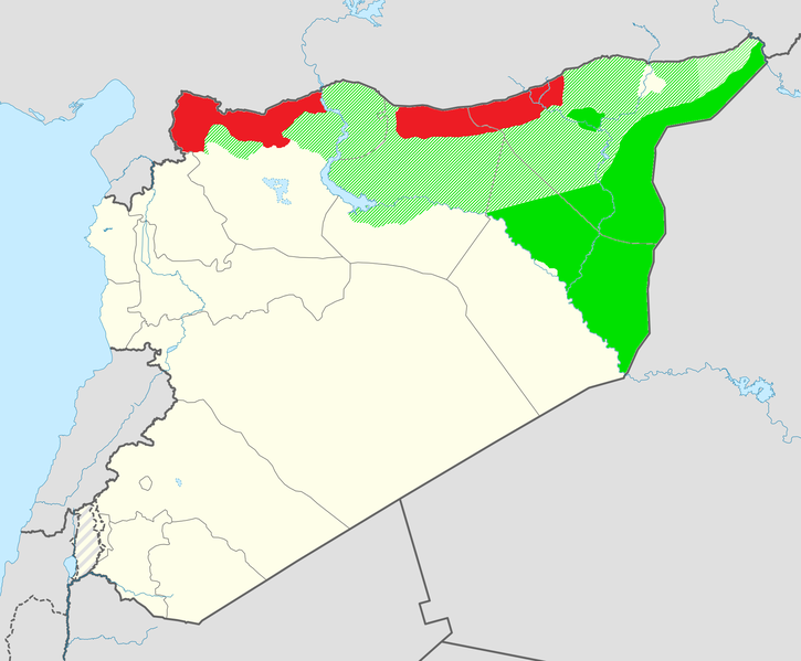
English: Claimed territory of Rojava (in orange) not currently under control and the de facto territory controlled by the Syrian Democratic Forces (in green). |
| Date | |
| Source | Own work |
| Author | Editor abcdef |
| Permission (Reusing this file) |
This image includes elements that have been taken or adapted from this file: |
Licensing
This file is licensed under the Creative Commons Attribution-Share Alike 3.0 Unported license.
- You are free:
- to share – to copy, distribute and transmit the work
- to remix – to adapt the work
- Under the following conditions:
- attribution – You must give appropriate credit, provide a link to the license, and indicate if changes were made. You may do so in any reasonable manner, but not in any way that suggests the licensor endorses you or your use.
- share alike – If you remix, transform, or build upon the material, you must distribute your contributions under the same or compatible license as the original.
File history
Click on a date/time to view the file as it appeared at that time.
| Date/Time | Thumbnail | Dimensions | User | Comment | |
|---|---|---|---|---|---|
| 08:03, 18 October 2019 |  | 2,000 × 1,653 (271 KB) | Bill497 | Saa at the border, Ras al-Ayn sieged. | |
| 07:36, 17 October 2019 |  | 2,000 × 1,653 (271 KB) | Bill497 | Update after SAA enters Kobani. | |
| 12:25, 15 October 2019 |  | 2,000 × 1,653 (270 KB) | Bill497 | Update this inline with File:Syrian Civil War map.svg and File:De facto cantons of Rojava.png | |
| 20:09, 28 December 2018 |  | 2,000 × 1,653 (267 KB) | Jim7049 | Qamislo, Afrin fix | |
| 12:16, 22 October 2018 |  | 2,000 × 1,653 (337 KB) | Ceha | Kurds have gained control of more teritories along iraq border and around Qamishli | |
| 14:58, 30 March 2018 |  | 2,000 × 1,653 (338 KB) | Ceha | Turks have conquered Afrin, added new color for Turkish occupation area. | |
| 06:20, 2 January 2018 |  | 2,000 × 1,653 (282 KB) | TheNavigatrr | Updated control | |
| 21:03, 9 December 2017 |  | 2,000 × 1,653 (282 KB) | TheNavigatrr | Updated control | |
| 23:04, 28 October 2017 |  | 2,000 × 1,653 (338 KB) | Ceha | Fixed error south of Marqada | |
| 22:57, 28 October 2017 |  | 2,000 × 1,653 (338 KB) | Ceha | SDF has advanced to the south according to this map; https://upload.wikimedia.org/wikipedia/commons/1/11/Syrian%2C_Iraqi%2C_and_Lebanese_insurgencies.png |
File usage
The following pages on the English Wikipedia use this file (pages on other projects are not listed):
- 2019 Turkish offensive into north-eastern Syria
- Afrin, Syria
- Autonomous Administration of North and East Syria
- Eastern Syria insurgency
- Foreign involvement in the Syrian civil war
- Northern Syria Buffer Zone
- People's Defense Units
- Rojava conflict
- Syrian Democratic Forces
- Syria–Turkey relations
- Timeline of the Kurdistan Workers' Party insurgency (2015–present)
- Turkish involvement in the Syrian civil war
- Turkish occupation of northern Syria
Global file usage
The following other wikis use this file:
- Usage on ar.wikipedia.org
- Usage on az.wikipedia.org
- Usage on bg.wikipedia.org
- Usage on cs.wikipedia.org
- Usage on da.wikipedia.org
- Usage on de.wikipedia.org
- Usage on es.wikipedia.org
- Usage on fa.wikipedia.org
- Usage on fi.wikipedia.org
- Usage on fr.wikipedia.org
- Usage on he.wikipedia.org
- Usage on hi.wikipedia.org
- Usage on hr.wikipedia.org
- Usage on hy.wikipedia.org
- Usage on ko.wikipedia.org
- Usage on ku.wikipedia.org
- Usage on lv.wikipedia.org
- Usage on pl.wikipedia.org
- Usage on pnb.wikipedia.org
- Usage on ro.wikipedia.org
- Usage on ru.wikipedia.org
- Usage on ru.wikinews.org
- Usage on tr.wikipedia.org
- Usage on uk.wikipedia.org
- Usage on ur.wikipedia.org
- Usage on vi.wikipedia.org
- Usage on www.wikidata.org
- Usage on zh-min-nan.wikipedia.org
- Usage on zh.wikipedia.org