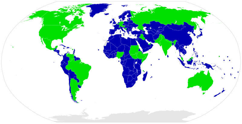
File:Map of unitary and federal states.svg

Size of this PNG preview of this SVG file: 800 × 411 pixels. Other resolutions: 320 × 164 pixels | 640 × 329 pixels | 1,024 × 526 pixels | 1,280 × 657 pixels | 2,560 × 1,314 pixels | 863 × 443 pixels.
Original file (SVG file, nominally 863 × 443 pixels, file size: 1.67 MB)
File history
Click on a date/time to view the file as it appeared at that time.
| Date/Time | Thumbnail | Dimensions | User | Comment | |
|---|---|---|---|---|---|
| 03:24, 1 August 2021 |  | 863 × 443 (1.67 MB) | Waberi4291 | Reverted to version as of 16:22, 9 March 2021 (UTC) | |
| 00:27, 22 May 2021 |  | 863 × 443 (1.62 MB) | Siirski | Somaliland is not a federal or member states of somalia. https://foreignpolicy.com/2021/05/18/dont-blame-me-for-delaying-somalias-elections/ | |
| 16:22, 9 March 2021 |  | 863 × 443 (1.67 MB) | Hurbad | Please stop changing original file and reducing the quality. This is vandalism | |
| 16:19, 9 March 2021 |  | 863 × 443 (1.62 MB) | Siirski | I downloaded the file for you, not mine. https://commons.wikimedia.org/wiki/File:Map_of_unitary_and_federal_states_(1).svg | |
| 16:12, 9 March 2021 |  | 863 × 443 (1.67 MB) | Hurbad | Please stop changing original file, please use duplicate to make personalised changes. | |
| 16:08, 9 March 2021 |  | 863 × 443 (1.62 MB) | Siirski | Reverted to version as of 15:48, 9 March 2021 (UTC) | |
| 15:52, 9 March 2021 |  | 863 × 443 (1.67 MB) | Hurbad | Please stop changing original file | |
| 15:48, 9 March 2021 |  | 863 × 443 (1.62 MB) | Siirski | I Already download it for you other file sow stop reverting. See : https://commons.wikimedia.org/wiki/File:Map_of_unitary_and_federal_states_(1).svg | |
| 15:38, 9 March 2021 |  | 863 × 443 (1.67 MB) | Hurbad | Two maps have been made, please use https://commons.wikimedia.org/wiki/File:Map_of_unitary_and_federal_states_(1).svg for those who are interested in Somaliland related issues. | |
| 14:48, 9 March 2021 |  | 863 × 443 (1.62 MB) | Siirski | https://www.mapsinternational.co.uk/national-geographic-world-executive-map.html#review |
File usage
The following pages on the English Wikipedia use this file (pages on other projects are not listed):
Global file usage
The following other wikis use this file:
- Usage on ar.wikipedia.org
- Usage on as.wikipedia.org
- Usage on av.wikipedia.org
- Usage on bh.wikipedia.org
- Usage on blk.wikipedia.org
- Usage on bn.wikipedia.org
- Usage on bs.wikipedia.org
- Usage on ca.wikipedia.org
- Usage on cs.wikipedia.org
- Usage on da.wikipedia.org
- Usage on din.wikipedia.org
- Usage on el.wikipedia.org
- Usage on eo.wikipedia.org
- Usage on es.wikipedia.org
- Usage on eu.wikipedia.org
- Usage on fa.wikipedia.org
- Usage on fi.wikipedia.org
- Usage on fo.wikipedia.org
- Usage on fr.wikipedia.org
- Usage on ha.wikipedia.org
- Usage on he.wikipedia.org
- Usage on hi.wikipedia.org
- Usage on hu.wikipedia.org
- Usage on hy.wikipedia.org
- Usage on id.wikipedia.org
- Usage on ilo.wikipedia.org
- Usage on is.wikipedia.org
- Usage on it.wikipedia.org
View more global usage of this file.


