
File:MongolEmpireDivisions1300.png
Size of this preview: 800 × 467 pixels. Other resolutions: 320 × 187 pixels | 640 × 373 pixels | 1,024 × 597 pixels | 1,644 × 959 pixels.
Original file (1,644 × 959 pixels, file size: 37 KB, MIME type: image/png)
| This is a file from the Wikimedia Commons. Information from its description page there is shown below. Commons is a freely licensed media file repository. You can help. |
Summary
| Description |
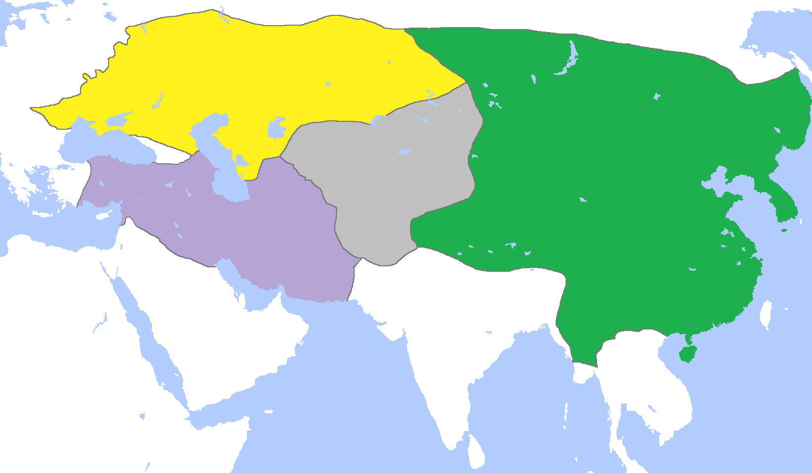
English: Map of the Mongol Empire c. 1300, after its four subdivisions into the:
Français : Carte des Divisions de l'Empire mongol vers 1300 :
|
| Date | |
| Source | Own work |
| Author | Gabagool |
Licensing
I, the copyright holder of this work, hereby publish it under the following license:
This file is licensed under the Creative Commons Attribution 3.0 Unported license.
- You are free:
- to share – to copy, distribute and transmit the work
- to remix – to adapt the work
- Under the following conditions:
- attribution – You must give appropriate credit, provide a link to the license, and indicate if changes were made. You may do so in any reasonable manner, but not in any way that suggests the licensor endorses you or your use.
File history
Click on a date/time to view the file as it appeared at that time.
| Date/Time | Thumbnail | Dimensions | User | Comment | |
|---|---|---|---|---|---|
| 11:33, 6 June 2013 |  | 1,644 × 959 (38 KB) | Garam | Reverted to version as of 13:48, 5 June 2013: nonresponse of User talk:Tm#Excuse me, sir. & Not only include Korea. | |
| 18:40, 5 June 2013 |  | 1,644 × 959 (61 KB) | Tm | Reverted to version as of 02:50, 23 December 2010 Please read : http://commons.wikimedia.org/w/index.php?title=Commons:Village_pump&diff=33196237&oldid=33196194 and https://secure.wikimedia.org/wikipedia/commons/wiki/Commons:Village_pump#Edit_warring_ove | |
| 13:48, 5 June 2013 |  | 1,644 × 959 (38 KB) | Garam | Only 双城总管府, noinclude the 東寧府, part of Hkakabo Razi in Kachin. | |
| 02:50, 23 December 2010 |  | 1,644 × 959 (61 KB) | Tm | Reverted to version as of 02:28, 19 December 2010: Please read : http://commons.wikimedia.org/w/index.php?title=Commons:Village_pump&diff=33196237&oldid=33196194 and https://secure.wikimedia.org/wikipedia/commons/wiki/Commons:Village_pump#Edit_warring_ove | |
| 02:37, 23 December 2010 |  | 1,644 × 959 (61 KB) | Historiographer~commonswiki | China was annexed to their territory. Mongol was abandon to absorb Korea, and they just made Korea as a tributary. | |
| 02:28, 19 December 2010 |  | 1,644 × 959 (61 KB) | Tm | Reverted to version as of 16:03, 18 December 2010 | |
| 00:09, 19 December 2010 |  | 1,644 × 959 (61 KB) | Historiographer~commonswiki | Reverted to version as of 09:12, 18 December 2010, There are no relationship with this page. | |
| 16:03, 18 December 2010 |  | 1,644 × 959 (61 KB) | Tm | Reverted to version as of 01:59, 18 December 2010 (please see the warning in Category:Maps_of_Korea) | |
| 09:12, 18 December 2010 |  | 1,644 × 959 (61 KB) | Garam | Need to fix for this file. I will fix for this file after 2 days. | |
| 01:59, 18 December 2010 |  | 1,644 × 959 (61 KB) | Tm | Reverted to version as of 18:31, 17 December 2010 |
File usage
The following pages on the English Wikipedia use this file (pages on other projects are not listed):
- Borjigin
- Chagatai Khanate
- Cumans
- Duwa
- Esen Buqa–Ayurbarwada war
- Golden Horde
- History of Mongolia
- History of Xinjiang
- History of the central steppe
- History of the western steppe
- Jayaatu Khan Tugh Temür
- Kaidu–Kublai war
- Külüg Khan
- Toqta
- Yuan dynasty in Inner Asia
- User:Falcaorib
- Template:Mongol Empire in 1300
Global file usage
The following other wikis use this file:
- Usage on af.wikipedia.org
- Usage on ar.wikipedia.org
- Usage on ast.wikipedia.org
- Usage on azb.wikipedia.org
- Usage on be-tarask.wikipedia.org
- Usage on bn.wikipedia.org
- Usage on ckb.wikipedia.org
- Usage on en.wikivoyage.org
- Usage on eo.wikipedia.org
- Usage on es.wikipedia.org
- Usage on et.wikipedia.org
- Usage on eu.wikipedia.org
- Usage on fa.wikipedia.org
- Usage on fr.wikipedia.org
- Usage on id.wikipedia.org
- Usage on it.wikipedia.org
- Usage on ja.wikipedia.org
- Usage on kk.wikipedia.org
- Usage on lv.wikipedia.org
- Usage on mn.wikipedia.org
- Usage on ro.wikipedia.org
- Usage on sl.wikipedia.org
View more global usage of this file.