
File:North Atlantic Treaty Organization (orthographic projection).svg

Size of this PNG preview of this SVG file: 550 × 550 pixels. Other resolutions: 240 × 240 pixels | 480 × 480 pixels | 768 × 768 pixels | 1,024 × 1,024 pixels | 2,048 × 2,048 pixels.
Original file (SVG file, nominally 550 × 550 pixels, file size: 484 KB)
| This is a file from the Wikimedia Commons. Information from its description page there is shown below. Commons is a freely licensed media file repository. You can help. |
Summary
| Description |
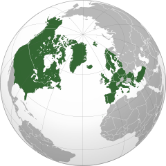
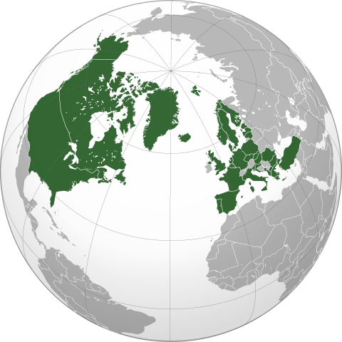
Deutsch: Die Organisation des Nordatlantikvertrags/ North Atlantic Treaty Organization (NATO) in einer orthografischen Projektion.
English: North Atlantic Treaty Organization in orthographic projection.
Español: Organización del Tratado del Atlántico Norte (OTAN).
Français : Projection orthographique de l'Organisation du Traité de l'Atlantique Nord.
Русский: Государства-члены Североатлантического Альянса (НАТО) на карте в ортогональной проекции.
Українська: Проєкція Організації Північноатлантичного договору (НАТО). |
||||
| Date | |||||
| Source |
Own work
|
||||
| Author | Addicted04 | ||||
| SVG development |

.svg)
Licensing
| This map is ineligible for copyright and therefore in the public domain, because it consists entirely of information that is common property and contains no original authorship. For more information, see Commons:Threshold of originality § Maps.
|
File history
Click on a date/time to view the file as it appeared at that time.
.svg)
.svg&dir=prev&offset=20200311183636)
.svg&offset=20200327161838&limit=20)
.svg&offset=20200327161838&limit=50)
.svg&offset=20200327161838&limit=100)
.svg&offset=20200327161838&limit=250)
.svg&offset=20200327161838&limit=500)
| Date/Time | Thumbnail | Dimensions | User | Comment | |
|---|---|---|---|---|---|
| 18:36, 11 March 2020 |  | 550 × 550 (848 KB) | Delusion23 | Coloured in Alaska islands, Puerto Rico and Canary Islands | |
| 18:40, 5 June 2017 |  | 550 × 550 (845 KB) | SilentResident | Montenegro joined NATO on 5 June 2017; updated map to reflect this. | |
| 22:33, 4 October 2011 |  | 550 × 550 (845 KB) | Patrickneil | Also adding South Sudan, per request | |
| 23:44, 3 October 2011 |  | 550 × 550 (844 KB) | Patrickneil | On pages about NATO, we try to use NATO policies, including about Kosovo, and its inclusion was requested on the talk page. | |
| 05:19, 25 March 2011 |  | 550 × 550 (1,006 KB) | Chipmunkdavis | Adding in French Guiana | |
| 02:19, 23 November 2010 |  | 550 × 550 (843 KB) | UrbanVillager | Reverted to version as of 00:19, 15 January 2010 Kosovo is not internationally recognized | |
| 18:47, 4 April 2010 |  | 550 × 550 (844 KB) | Patrickneil | adding French Guyana per discussion at en:Talk:NATO#Error_ in Map : French Guyana Missing, and some borders for Kosovo | |
| 00:19, 15 January 2010 |  | 550 × 550 (843 KB) | Addicted04 | - KO | |
| 02:48, 7 December 2009 |  | 550 × 550 (838 KB) | Addicted04 | + Albania, Bulgaria, Romania, Latvia, Lithuania and Estonia. | |
| 00:29, 8 October 2009 |  | 550 × 550 (835 KB) | Addicted04 | {{Information |Description={{en|1=North Atlantic Treaty Organization in orthographic projection.}} |Source={{own}}{{Inkscape}}{{GFDL-GMT|migration=redundant}} |Author=Addicted04 |Date=2009-10-08 |Permission= |other_versions= }} [[Cate |
File usage
The following pages on the English Wikipedia use this file (pages on other projects are not listed):
- Collective security
- Hegemony
- List of European countries by membership in international organisations
- List of regional organizations by population
- Nuclear-weapon-free zone
- Power (international relations)
- Talk:NATO/Archive 3
- Talk:Schengen Area/Archive 1
- User:Ajhuheu2
- User:Blitz1980
- User:Centralismo/Userboxes
- User:Dare2Leap/info
- User:DarklitShadow/Userboxes
- User:DecearingEgg712
- User:DimensionalFusion
- User:DimensionalFusion/userboxes
- User:Dylanmc678
- User:EPBeatles
- User:Ed1984
- User:Einnerst
- User:Extended Cut
- User:Ezoiar/Userboxes
- User:Falcaorib
- User:FrederalBacon
- User:Half-kratos21
- User:ITZQing
- User:Jedi Master Wysk
- User:Kavysca
- User:Kitola
- User:Koustav Chatterjee
- User:Limorina
- User:Manuela Listkiewska
- User:MarcoHamilton12
- User:MingyueH/sandbox
- User:Mona23653
- User:Nightwalker-87
- User:Niki 24
- User:Oberhof
- User:PhillyBonkers
- User:Radzy0
- User:Randomperson43322
- User:RenewEuropa
- User:RobertPlausible
- User:SablinTheBlessed
- User:Ships&Space/About me
- User:Ships&Space/Userboxes
- User:Spinykitsune65/sandbox2
- User:Suðreyjar
- User:ThaddeusOrlando55
- User:TheSouthernIrishman
- User:TheUnabashedUkrainian
- User:UPD25
- User:VSA72
- User:Winderz IoT
- User:Yulia Romero
- User:Yulia Romero/OpinionsOfYulia Romero
- User:Zemant
- User:Zemant from Supernova
- User:Антон патріот
- User talk:Delusion23/Archive 15
- Wikipedia:Main Page history/2020 March 30
- Wikipedia:Main Page history/2020 March 31
- Wikipedia:Top 25 Report/February 27 to March 5, 2022
- Wikipedia:Userboxes/Politics/Multinational
- Wikipedia:Userboxes/Politics by country
- Wikipedia:Userboxes/Politics by country/02
- Wikipedia:Userboxes/Politics by country/04
- Wikipedia:Userboxes/Politics by country/05
- Wikipedia:Userboxes/Politics by country/Ireland
- Wikipedia:Userboxes/Politics by country/Ukraine
- Template:User Andorra NATO
- Template:User Austria NATO
- Template:User Bosnia and Herzegovina NATO
- Template:User Finland NATO
- Template:User Ireland NATO
- Template:User Malta NATO
- Template:User Monaco NATO
- Template:User San Marino NATO
- Template:User Sweden NATO
- Template:User Ukraine NATO
Global file usage
The following other wikis use this file:
- Usage on als.wikipedia.org
- Usage on an.wikipedia.org
- Usage on ar.wikipedia.org
- Usage on ar.wikinews.org
- Usage on as.wikipedia.org
- Usage on azb.wikipedia.org
- Usage on az.wikipedia.org
- Usage on ba.wikipedia.org
- Usage on bcl.wikipedia.org
- Usage on be-tarask.wikipedia.org
- Usage on be.wikipedia.org
- Usage on bg.wikipedia.org
- Usage on bh.wikipedia.org
- Usage on bn.wikipedia.org
- Usage on bs.wikipedia.org
- Usage on bxr.wikipedia.org
- Usage on ca.wikipedia.org
- Usage on ca.wikinews.org
- Usage on cbk-zam.wikipedia.org
- Usage on cdo.wikipedia.org
- Usage on ceb.wikipedia.org
- Usage on ce.wikipedia.org
- Usage on ckb.wikipedia.org
- Usage on cs.wikipedia.org
- Usage on cy.wikipedia.org
- Usage on da.wikipedia.org
- Usage on de.wikipedia.org
- Usage on de.wikinews.org
- Usage on el.wikipedia.org
- Usage on en.wikinews.org
- Usage on en.wikiquote.org
- Usage on es.wikipedia.org
- Usage on et.wikipedia.org
- Usage on fa.wikipedia.org
View more global usage of this file.
.svg)
.svg)