
File:Persian Language Location Map.svg

Size of this PNG preview of this SVG file: 650 × 430 pixels. Other resolutions: 320 × 212 pixels | 640 × 423 pixels | 1,024 × 677 pixels | 1,280 × 847 pixels | 2,560 × 1,694 pixels.
Original file (SVG file, nominally 650 × 430 pixels, file size: 2.8 MB)
| This is a file from the Wikimedia Commons. Information from its description page there is shown below. Commons is a freely licensed media file repository. You can help. |
Summary
==⧼filed esc⧽==
| Description |
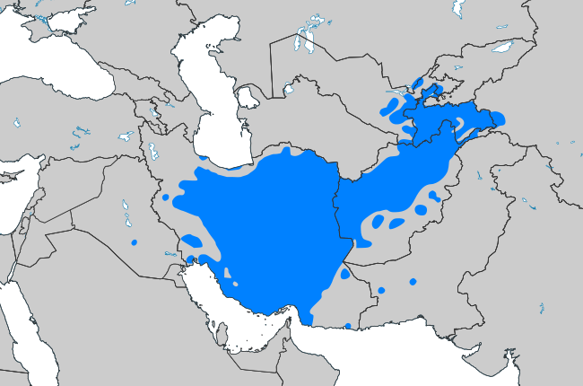
English: Areas with Persian-speakers as mother tongue فارسی: نواحی سکونت فارسیزبانان Română: Zone unde limba persană e vorbită ca limbă maternă Magyar: A perzsa nyelv elterjedése |
| Date | |
| Source | Vectorization Own work, based on this PNG map |
| Author | ArnoldPlaton |
Licensing
I, the copyright holder of this work, hereby publish it under the following license:
This file is licensed under the Creative Commons Attribution-Share Alike 3.0 Unported license.
- You are free:
- to share – to copy, distribute and transmit the work
- to remix – to adapt the work
- Under the following conditions:
- attribution – You must give appropriate credit, provide a link to the license, and indicate if changes were made. You may do so in any reasonable manner, but not in any way that suggests the licensor endorses you or your use.
- share alike – If you remix, transform, or build upon the material, you must distribute your contributions under the same or compatible license as the original.
File history
Click on a date/time to view the file as it appeared at that time.
| Date/Time | Thumbnail | Dimensions | User | Comment | |
|---|---|---|---|---|---|
| 22:24, 4 November 2020 |  | 650 × 430 (2.8 MB) | Rizorius | better colours and size | |
| 12:41, 19 October 2020 |  | 900 × 500 (4.4 MB) | Rizorius | minor edits | |
| 12:34, 19 October 2020 |  | 900 × 500 (4.4 MB) | Rizorius | According to discussions here | |
| 20:45, 17 October 2020 |  | 900 × 500 (4.4 MB) | Rizorius | caspian languages border | |
| 07:49, 14 October 2020 |  | 900 × 500 (4.4 MB) | Rizorius | Reverted to version as of 17:20, 13 October 2020 (UTC) | |
| 23:26, 13 October 2020 |  | 1,024 × 569 (1.25 MB) | Kelardashtian | Reverted to version as of 02:14, 13 October 2020 (UTC) | |
| 17:20, 13 October 2020 |  | 900 × 500 (4.4 MB) | Rizorius | Reverted to version as of 09:49, 8 October 2020 (UTC) | |
| 02:14, 13 October 2020 |  | 1,024 × 569 (1.25 MB) | Kelardashtian | The people of Mazandaran province speak the Mazandarani language. The people of Gilan province speak the Gilaki language. The people of Semnan speak the language of Semnani. People in the west of Golestan province speak Mazandarani language. People in the north of Golestan province speak Turkmeni language. | |
| 09:49, 8 October 2020 |  | 900 × 500 (4.4 MB) | Rizorius | change color and border | |
| 21:03, 3 October 2016 |  | 900 × 500 (4.4 MB) | BurritoBazooka | make Lesotho visible on minimap (was hidden behind South Africa) |
File usage
The following pages on the English Wikipedia use this file (pages on other projects are not listed):
Global file usage
The following other wikis use this file:
- Usage on ab.wikipedia.org
- Usage on ace.wikipedia.org
- Usage on ady.wikipedia.org
- Usage on af.wikipedia.org
- Usage on als.wikipedia.org
- Usage on am.wikipedia.org
- Usage on ang.wikipedia.org
- Usage on anp.wikipedia.org
- Usage on an.wikipedia.org
- Usage on arc.wikipedia.org
- Usage on ar.wikipedia.org
- اللغة الفارسية
- الشاهنامه
- خط فارسي
- ژ
- نستعليق
- أبجدية طاجيكية
- اللغة الطاجيكية
- اللغة الدرية
- أبجدية فارسية
- أدب فارسي
- اللغة البهلوية
- خط بهلوي
- ويكيبيديا:مشروع ويكي إيران/شيراز
- فارسية صافية
- إضافة (فارسية)
- واو معدولة
- واو مجهولة
- قاموس دهخدا
- أدب بهلوي
- علي أكبر دهخدا
- ثقافة فارسية
- اللغة الفارسية القديمة
- بوابة:العالم الإسلامي/لغة مختارة/أرشيف
- بوابة:العالم الإسلامي/لغة مختارة/7
- لهجة فارسية كويتية
- قواعد اللغة الفارسية
- فارسية إيرانية
- قالب:لغة فارسية
- اللغة الأتشومية
- كتابة نقشية بهلوية
- Usage on ar.wikibooks.org
- Usage on ary.wikipedia.org
- Usage on arz.wikipedia.org
- Usage on ast.wikipedia.org
- Usage on ast.wiktionary.org
- Usage on as.wikipedia.org
View more global usage of this file.