
File:Special member state territories and the European Union.svg

Size of this PNG preview of this SVG file: 512 × 258 pixels. Other resolutions: 320 × 161 pixels | 640 × 323 pixels | 1,024 × 516 pixels | 1,280 × 645 pixels | 2,560 × 1,290 pixels.
Original file (SVG file, nominally 512 × 258 pixels, file size: 835 KB)
| This is a file from the Wikimedia Commons. Information from its description page there is shown below. Commons is a freely licensed media file repository. You can help. |
Summary
| Description |
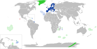
English:
European Union
Outermost regions
Overseas countries and territories
Special cases
Other special territories Français : Union européenne
Régions ultrapériphériques
Pays et territoires d'outre-mer
Cas spéciaux
Autres territoires spéciaux |
| Date | |
| Source | Own work |
| Author | Glentamara |
| SVG development |
Licensing
| I, the copyright holder of this work, release this work into the public domain. This applies worldwide. In some countries this may not be legally possible; if so: I grant anyone the right to use this work for any purpose, without any conditions, unless such conditions are required by law. |
File history
Click on a date/time to view the file as it appeared at that time.
| Date/Time | Thumbnail | Dimensions | User | Comment | |
|---|---|---|---|---|---|
| current | 19:12, 8 June 2022 | | 512 × 258 (835 KB) | Nablicus | new version |
| 10:13, 17 July 2020 |  | 512 × 259 (736 KB) | Alcaios | fixed – those were models I use to check the scale | |
| 23:03, 16 July 2020 |  | 512 × 258 (672 KB) | Nablicus | Reverted to version as of 19:08, 16 July 2020 (UTC). There is an extra UK and Iceland in the middle of Canada... | |
| 19:53, 16 July 2020 |  | 512 × 259 (753 KB) | Alcaios | frame | |
| 19:50, 16 July 2020 |  | 512 × 258 (681 KB) | Alcaios | minor fixed on Greenland mar. zone | |
| 19:46, 16 July 2020 |  | 512 × 258 (681 KB) | Alcaios | Added maritime zone of Gree,land based on https://www.marineregions.org/eezdetails.php?mrgid=8438 | |
| 19:32, 16 July 2020 |  | 512 × 259 (752 KB) | Alcaios | added Faroe Islands' maritime zone | |
| 19:08, 16 July 2020 |  | 512 × 258 (672 KB) | Alcaios | Maritime zones in the eastern Caribbean at the right scale, with the help of https://commons.wikimedia.org/wiki/File:Caribbean_maritime_boundaries_map.svg | |
| 18:44, 16 July 2020 |  | 512 × 259 (742 KB) | Alcaios | slight realignments | |
| 18:38, 16 July 2020 |  | 512 × 259 (742 KB) | Alcaios | typo in previous edit, read: "Northern Cyprus is not a special member state territory since..." –– the Åland archipelago is larger and almost reaches the Finnish coast | |
| 18:24, 16 July 2020 |  | 512 × 258 (672 KB) | Alcaios | Northern Cyprus is not a special member territory state since it's not in effective control of any EU member state, whereas inhabited villages in the UN buffer zone are under the jurisdiction of the Republic of Cyprus (and monitored by UN soldiers) | |
| 14:08, 16 July 2020 |  | 512 × 258 (834 KB) | Nablicus | Add South Sudan | |
| 13:35, 16 July 2020 |  | 512 × 258 (831 KB) | Nablicus | correction, Gotland is not a special territory, but Åland is | |
| 10:45, 16 July 2020 |  | 512 × 258 (744 KB) | Alcaios | everything should be good now | |
| 10:41, 16 July 2020 |  | 512 × 260 (669 KB) | Alcaios | fix | |
| 10:26, 16 July 2020 |  | 512 × 260 (678 KB) | Alcaios | fix | |
| 10:24, 16 July 2020 |  | 512 × 260 (678 KB) | Alcaios | fix | |
| 10:19, 16 July 2020 |  | 512 × 260 (678 KB) | Alcaios | fix | |
| 10:13, 16 July 2020 |  | 512 × 260 (824 KB) | Alcaios | added special cases | |
| 12:05, 3 February 2020 |  | 940 × 477 (1.8 MB) | Nablicus | Update new version | |
| 22:39, 31 January 2020 |  | 940 × 477 (1.81 MB) | Nablicus | Update | |
| 19:42, 30 July 2018 |  | 940 × 477 (1.85 MB) | Masterdeis | new status for Bermuda (OCT, 2014) + Malta (invisible on the previous version) | |
| 16:51, 31 December 2013 |  | 940 × 477 (1.85 MB) | Nablicus | Mayotte | |
| 20:33, 30 June 2013 |  | 940 × 477 (1.85 MB) | Nablicus | update | |
| 00:17, 18 December 2010 |  | 940 × 477 (1.85 MB) | Nablicus | correction | |
| 00:02, 18 December 2010 |  | 940 × 477 (1.85 MB) | Nablicus | white area removed | |
| 00:01, 18 December 2010 |  | 940 × 477 (1.85 MB) | Nablicus | new version again | |
| 23:58, 17 December 2010 |  | 940 × 477 (1.85 MB) | Nablicus | new version | |
| 18:04, 16 December 2010 |  | 940 × 477 (1.75 MB) | Nablicus | new version | |
| 21:28, 11 December 2010 |  | 940 × 477 (1.75 MB) | Nablicus | Greenland | |
| 21:24, 11 December 2010 |  | 940 × 477 (1.75 MB) | Nablicus | new colors | |
| 23:17, 19 July 2009 |  | 940 × 477 (1.75 MB) | Nablicus | new version | |
| 22:56, 6 February 2009 |  | 940 × 477 (1.75 MB) | Nablicus | Clipperton | |
| 11:12, 4 February 2009 |  | 940 × 477 (1.75 MB) | Nablicus | Zones | |
| 21:00, 2 February 2009 |  | 940 × 477 (1.74 MB) | Nablicus | minor edits | |
| 16:11, 2 February 2009 |  | 940 × 477 (1.73 MB) | Nablicus | Antarctica | |
| 21:57, 30 January 2009 |  | 940 × 477 (1.7 MB) | Nablicus | new version | |
| 11:13, 19 February 2008 |  | 940 × 477 (2.35 MB) | Nablicus | Kosovo | |
| 12:15, 4 November 2007 |  | 940 × 477 (2.34 MB) | Nablicus | ||
| 12:13, 4 November 2007 |  | 940 × 477 (2.34 MB) | Nablicus | Fixing the Netherlands Antilles | |
| 12:10, 4 November 2007 |  | 940 × 477 (2.34 MB) | Nablicus | ||
| 12:03, 4 November 2007 |  | 940 × 477 (2.34 MB) | Nablicus | ||
| 11:58, 4 November 2007 |  | 940 × 477 (2.34 MB) | Nablicus | correcting texts and flags | |
| 11:38, 4 November 2007 |  | 940 × 477 (2.26 MB) | Nablicus | ||
| 11:54, 3 November 2007 |  | 940 × 477 (2.25 MB) | Nablicus | ||
| 11:51, 3 November 2007 |  | 940 × 477 (2.25 MB) | Nablicus | ||
| 11:42, 3 November 2007 |  | 940 × 477 (2.25 MB) | Nablicus | Fixing the texts. | |
| 11:33, 3 November 2007 |  | 940 × 477 (2.25 MB) | Nablicus | ||
| 11:22, 3 November 2007 |  | 940 × 477 (2.25 MB) | Nablicus | ||
| 10:05, 3 November 2007 |  | 940 × 477 (2.24 MB) | Nablicus | ||
| 09:53, 3 November 2007 |  | 940 × 477 (2.33 MB) | Nablicus | New version. | |
| 09:47, 3 November 2007 |  | 940 × 477 (2.33 MB) | Nablicus | {{Information |Description={{legend|#2c325f|European Union}}{{legend|#4f61b0|Outermost regions}}{{legend|#245423|Overseas countries and territories}} |Source=self-made |Date=2007-11-03 |Author=glentamara |Permission= |other_versions= }} |
File usage
The following pages on the English Wikipedia use this file (pages on other projects are not listed):
- European Union
- External border of the European Union
- Neocolonialism
- Outline of the European Union
- Potential enlargement of the European Union
- Special territories of members of the European Economic Area
- User:A diehard editor/sandbox/EU infobox
- User:Falcaorib
- User:Spinykitsune65/sandbox2
- User:Xicomaia/sandbox
Global file usage
The following other wikis use this file:
- Usage on ar.wikipedia.org
- Usage on br.wikipedia.org
- Usage on cs.wikipedia.org
- Usage on de.wikipedia.org
- Usage on fa.wikipedia.org
- Usage on fr.wikipedia.org
- Aruba
- Ceuta
- Polynésie française
- Groenland
- Açores
- Saint-Pierre-et-Miquelon
- Îles Canaries
- Madère
- Îles Kerguelen
- Île Clipperton
- Îles Féroé
- Région ultrapériphérique
- Îles Éparses de l'océan Indien
- Curaçao
- Åland
- Melilla
- Archipel Crozet
- Terre Adélie
- Bonaire
- Saba
- Saint-Eustache (Antilles)
- Peñón de Vélez de la Gomera
- Peñón de Alhucemas
- Îles Saint-Paul et Amsterdam
- Plazas de soberanía
- Nouvelle-Calédonie
- Saint-Martin (royaume des Pays-Bas)
- Saint-Martin (Antilles françaises)
- Pays et territoire d'outre-mer
- Saint-Barthélemy (Antilles françaises)
- Union européenne
- États membres de l'Union européenne
- Terres australes et antarctiques françaises
- Pays-Bas caribéens
- Wallis-et-Futuna
- Territoires associés à l'Union européenne
- Modèle:Palette Dépendances de l'UE
- Modèle:Territoires associés à l'Union européenne
- Utilisateur:Gribouille69/Brouillon
- Histoire de Curaçao
- Histoire de Saint-Eustache
- Histoire de Saint-Martin (Antilles françaises)
- Við Áir
View more global usage of this file.