
Okemah, Phoenix: Difference between revisions
Added info to infobox Tags: Mobile edit Mobile web edit |
Added to history Tags: Visual edit Mobile edit Mobile web edit |
||
| Line 40: | Line 40: | ||
The Okemah community was built between 32nd Street and 48th Street, and from Broadway Road to the South and the [[Salt River (Arizona)|Salt River]] to the North.<ref name=":0" /><ref>{{Cite web |title=Okemah Community — The Beginning of The Okemah Community and its Growth Through the Years |url=https://okemahcommunity.com/ |access-date=2024-03-18 |website=Okemah Community Historic Foundation |language=en-US}}</ref> |
The Okemah community was built between 32nd Street and 48th Street, and from Broadway Road to the South and the [[Salt River (Arizona)|Salt River]] to the North.<ref name=":0" /><ref>{{Cite web |title=Okemah Community — The Beginning of The Okemah Community and its Growth Through the Years |url=https://okemahcommunity.com/ |access-date=2024-03-18 |website=Okemah Community Historic Foundation |language=en-US}}</ref> |
||
Many of the residents migrated from Okemah and [[Boley, Oklahoma|Boley]], Oklahoma. This new community, like the Oklahoma town before it, was named for the Native America chief, Okemah, from the [[Kickapoo Tribe of Oklahoma|Kickapoo Tribe]].<ref>{{Cite web |title=Okemah Community — Chief Okemah |url=https://okemahcommunity.com/about-us/ |access-date=2024-03-18 |website=Okemah Community Historic Foundation |language=en-US}}</ref> |
Many of the residents migrated from Okemah and [[Boley, Oklahoma|Boley]], Oklahoma. This new community, like the Oklahoma town before it, was named for the Native America chief, Okemah, from the [[Kickapoo Tribe of Oklahoma|Kickapoo Tribe]].<ref>{{Cite web |title=Okemah Community — Chief Okemah |url=https://okemahcommunity.com/about-us/ |access-date=2024-03-18 |website=Okemah Community Historic Foundation |language=en-US}}</ref> |
||
In the mid 1960s, the Okemah community began to change as plans were announced to build an extension of Interstate 10 through the town. Homes were bought through eminent domain, several homes and businesses were demolished and families were forced to move elsewhere. Even residents who were not in the path of the freeway began to move as more industrial businesses began to move into the area. Interstate 10's Broadway Curve opened in 1971 and bisected the community.<ref>{{Cite web |last=Seely |first=Taylor |date=2024-02-10 |title=The lost legacy of Okemah: A historic Black community in Phoenix decimated by highways |url=https://subscribe.azcentral.com/restricted |access-date=2024-03-19 |website=azcentral.com}}</ref><ref name=":0" /> |
|||
== Legacy == |
== Legacy == |
||
Revision as of 05:51, 19 March 2024
Okemah | |
|---|---|
Neighborhood | |
 Okemah Location in Arizona | |
| Coordinates: 33°25′0.245″N 112°0′1.731″W / 33.41673472°N 112.00048083°W | |
| Country | United States |
| State | Arizona |
| City | Phoenix |
| Named for | Okemah, Oklahoma |
| Area | |
| • Total | 2.75 sq mi (7.1 km2) |
| Elevation | 1,100 ft (342 m) |
| Website | https://okemahcommunity.com/ |
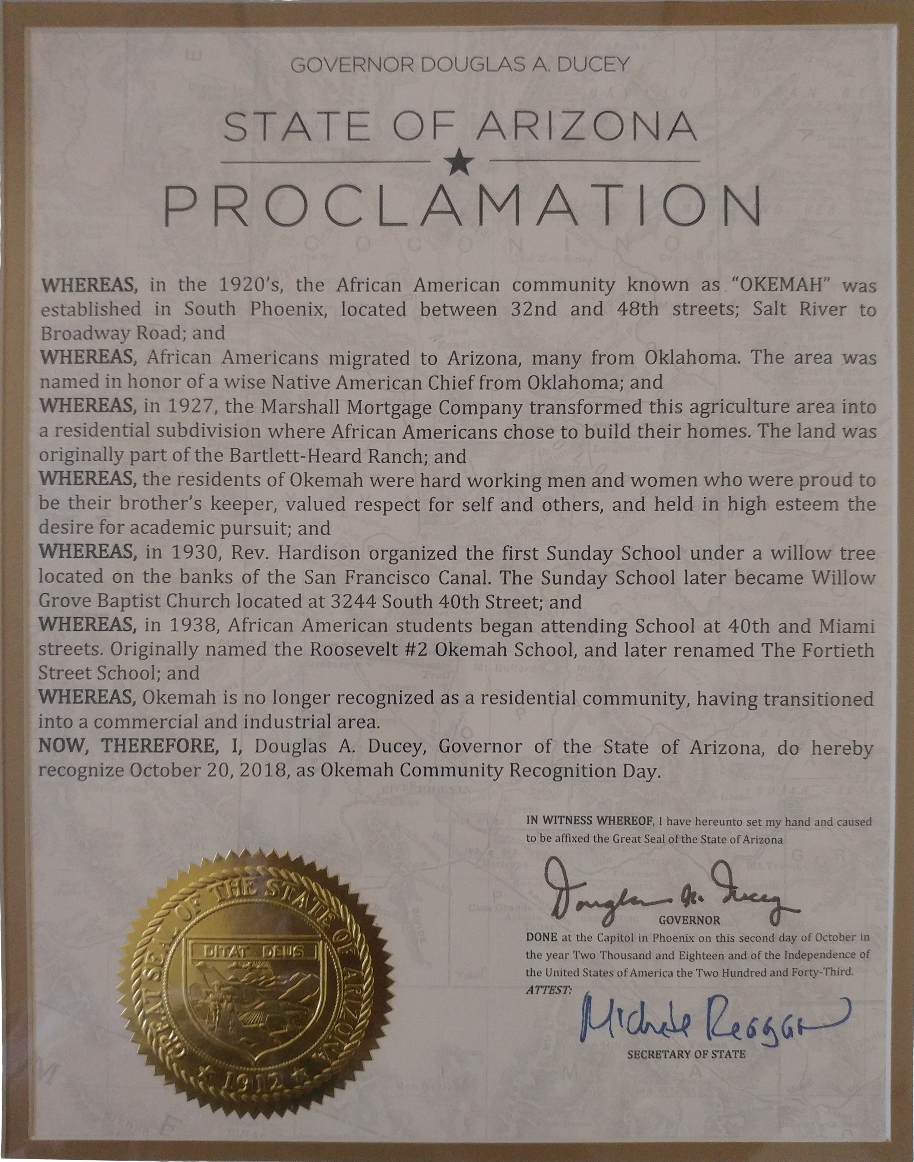
Okemah (Oh-Kee-Mah) was a neighborhood founder in the 1920s by black migrants, now apart of present day Phoenix, Arizona. Most of the original residents moved from Oklahoma (especially Okemah) and Texas, looking for work on farms in the area. The neighborhood was one of the few areas due to segregation and redlining, that black families could buy land and build homes in the Phoenix area.[1][2]
History
The land where Okemah would be built was originally a part of the Bartlett-Heard Ranch, owned by Maie Bartlett Heard and Dwight B. Heard. In 1927, the Marshall Mortgage Company transformed the ranches agricultural land into a residential subdivision, allowing more construction of homes and more residents to move in.[3]
The Okemah community was built between 32nd Street and 48th Street, and from Broadway Road to the South and the Salt River to the North.[1][4]
Many of the residents migrated from Okemah and Boley, Oklahoma. This new community, like the Oklahoma town before it, was named for the Native America chief, Okemah, from the Kickapoo Tribe.[5]
In the mid 1960s, the Okemah community began to change as plans were announced to build an extension of Interstate 10 through the town. Homes were bought through eminent domain, several homes and businesses were demolished and families were forced to move elsewhere. Even residents who were not in the path of the freeway began to move as more industrial businesses began to move into the area. Interstate 10's Broadway Curve opened in 1971 and bisected the community.[6][1]
Legacy
While little remains of the original community today, some buildings still remain, such as the former Willow Grove Baptist church.[1]
Some references to Okemah can also still be found such as on the sign for the Okemah Service Center.[1]
- ^ a b c d e "Okemah Community descendants work to preserve history". ABC15 Arizona. 2022-02-24. Retrieved 2024-03-18.
- ^ Seely, Taylor (February 10, 2024). "Bringing Okemah's legacy, values to life". Arizona Republic. Retrieved 2024-03-18.
- ^ Ducey, Douglas A. (2018-10-20). "State of Arizona Proclamation — Okemah Community Recognition". Okemah Community Historic Foundation. Retrieved 2024-03-18.
- ^ "Okemah Community — The Beginning of The Okemah Community and its Growth Through the Years". Okemah Community Historic Foundation. Retrieved 2024-03-18.
- ^ "Okemah Community — Chief Okemah". Okemah Community Historic Foundation. Retrieved 2024-03-18.
- ^ Seely, Taylor (2024-02-10). "The lost legacy of Okemah: A historic Black community in Phoenix decimated by highways". azcentral.com. Retrieved 2024-03-19.