
Pongo, Kentucky
Pongo | |
|---|---|
 Pongo Location within the state of Kentucky  Pongo Pongo (the United States) | |
| Coordinates: 37°13′21″N 84°19′23″W / 37.22250°N 84.32306°W | |
| Country | United States |
| State | Kentucky |
| County | Rockcastle |
| Elevation | 1,335 ft (407 m) |
| Time zone | UTC-5 (Eastern (EST)) |
| • Summer (DST) | UTC-4 (EST) |
| GNIS feature ID | 514705[1] |
Pongo, is an unincorporated community in Rockcastle County, Kentucky, United States. It is located on Kentucky Route 1249 south of Mount Vernon.
References[edit]
Municipalities and communities of Rockcastle County, Kentucky, United States | ||
|---|---|---|
| Cities | 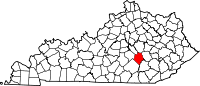 | |
| Unincorporated communities | ||
This Rockcastle County, Kentucky state location article is a stub. You can help Wikipedia by expanding it. |