
User:Kellnerp/sandbox
| Bukhansan | |
|---|---|
 Insu Peak on Bukhansan
 Bukhansan Location | |
| Highest point | |
| Elevation | 836.5 m (2,744 ft)[1] |
| Coordinates | 37°39′39″N 126°59′36″E / 37.6608°N 126.9933°E |
| Geography | |
| Location | South Korea |
| Climbing | |
| Easiest route | from Suyu Station by bus 1218 or 153 to Uidongdoseonsaipgu bus stop(우이동도선사입구) then walk 2.29km to Bukansan National Park Visitor Center(북한산국립공원백운탐방지원센터) |
| Korean name | |
| Hangul | |
|---|---|
| Hanja | |
| Revised Romanization | Bukhansan |
| McCune–Reischauer | Puk'ansan |
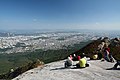
Bukhansan, or Bukhan Mountain, is a mountain on the northern periphery of Seoul, South Korea. There are three major peaks, Baegundae 836.5 meters (2,744 ft), Insubong 810.5 meters (2,659 ft), Mangyeongdae 787.0 meters (2,582.0 ft)[2]. Because of it's height and the fact that it borders a considerable portion of the city, Bukhansan is a major landmark visible from most city districts. The name "Bukhansan" means "big mountain in the north", referring to the fact that it is the northern border of the city.[3]. During the Joseon era, the peaks marked the extreme northern boundary of Seoul. Popular throughout the year, Bukhansan, and Bukhansan National Park, which was formed in 1983,[4] are renowned for birdwatching, hiking and rockclimbing. Bukhansan attracts a large number of hikers; around 5 million per year.
Bukhansan is the highest mountain within Seoul city boundaries. Apart from Bukhansan, there are seven other mountains including Dobongsan and Suraksan that are over 600 meters high within the city.[5]
Name
Since 2002 there has been a movement to revert the name of Bukhansan to Samkaksan. For many years up until now, the three main peaks of the park have collectively been called "Bukhansan"; however, the original collective name of the these three peaks was Samkaksan, meaning "three horned mountain." The head of the Gangbuk-gu District Office in Seoul is leading a petition to have the central government change the name back to the original.[6]
Hiking
There are numerous hiking courses accessible to the average hiker within Bukhansan National Park. The trails are open year round but may be closed during fire season in the Spring and Autumn at the discretion of the park director. class="wikitable "[7]
Gallery
-

-

-
-
-

-

-
-
-
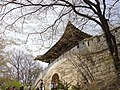
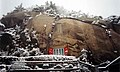 A shrine in Bukhansan


Films and Literature
Daum webtoon manwha "PEAK" by author Hong Sun-soo and artist Im Gak-hyuck is a fictional work based on the mountain rescue team working in this mountain.
References
- ^ "Bukhansan(북한산)". http://map.naver.com/local/siteview.nhn?code=11491416. NAVER. Retrieved 27 February 2015.
{{cite web}}: External link in|website= - ^ "Bukhansan(북한산)". http://map.naver.com/local/siteview.nhn?code=11491416. NAVER. Retrieved 27 February 2015.
{{cite web}}: External link in|website= - ^ "Bukhansan National Park (Dobong) (북한산국립공원(도봉 지구))". http://english.visitkorea.or.kr/enu/SI/SI_EN_3_1_1_1.jsp?cid=264309. KOREA TOURISM ORGANIZATION. Retrieved 27 February 2015.
{{cite web}}: External link in|website= - ^ "Introduction to Bukhansan". http://english.knps.or.kr/Knp/Bukhansan/Intro/Introduction.aspx?MenuNum=1&Submenu=Npp. Korea National Park Service. Retrieved 27 February 2015.
{{cite web}}: External link in|website= - ^ "Best Hiking Mountains in Seoul". Visit Korea. Retrieved 17 November 2012.
- ^ Park, Jin-woo (박진우) (2007-06-14). "북한산, 본래 이름 '삼각산' 되찾아야". Sports Hankook. Retrieved 2007-06-21.
- ^ "Bukhansan National Park (Dobong) (북한산국립공원(도봉 지구))". http://english.visitkorea.or.kr/enu/SI/SI_EN_3_1_1_1.jsp?cid=264309. KOREA TOURISM ORGANIZATION. Retrieved 27 February 2015.
{{cite web}}: External link in|website= - ^ http://webtoon.daum.net/webtoon/view/peak
External links
- Best Hiking Mountains in Seoul by Visit Korea, 2012
- Bukhansan National Park (북한산국립공원) by Visit Korea, 2012
- Bukhansan Hiking Club, 2014