Åros
Appearance

Åros is a village in Røyken municipality in Buskerud, Norway.
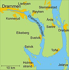
Åros is located on the peninsula of Hurumlandet along the western side of the Oslofjord. It is situated north of the village of Sætre, about 40 km south of Oslo and 25 km southeast of Drammen. Norwegian County Road 11 (Fylkesvei 11) runs through Åros from Krokodden to Sætre. The closest railway station is located at Røyken. [1]
Åros is the location of Åros chapel (Åros kapell) which dates from 1903. The church is constructed of wood and has 150 seats. Between 1963-1965, major improvements were implemented on the church. It is associated with the Diocese of Tunsberg, with the Church of Norway.[2] [3]
The population of Åros (2005) is about 1 142.[4]
References
- ^ Fylkesveg 11 Åros–Krokodden (Statens vegvesen)
- ^ Åros kapell (Norges Kirker. Sigrid Marie Christie, Håkon Christie)
- ^ Åros kirke (Den Norske Kirke)
- ^ Statistics Norway (2005). "Urban settlements. Population and area, by municipality. 1 January 2005".
{{cite journal}}: Cite journal requires|journal=(help)
