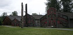
'Ksan
Appearance
(Redirected from ʼKsan)
 | |
 | |
| Location | near Hazelton, British Columbia |
|---|---|
| Type | Historical village and living museum |
| Website | www |
ʼKsan is a historical village and living museum of the Gitxsan Indigenous people in the Skeena Country of Northwestern British Columbia, Canada. ʼKsan is located near Hazelton at the confluence of the Skeena and Bulkley Rivers on Gitxsan territory.
History
[edit]
ʼKsan was founded before Hazelton was in 1866, and was populated by the Gitxsan Indigenous people.
See also
[edit]References
[edit]External links
[edit]55°14′58″N 127°40′47″W / 55.24944°N 127.67972°W
Wikimedia Commons has media related to 'Ksan.
