
Dreischor
Dreischor | |
|---|---|
Town | |
 Flag  Coat of arms | |
 | |
 The town centre (dark green) and the statistical district (light green) of Dreischor in the municipality of Schouwen-Duiveland. | |
| Coordinates: 51°41′19″N 3°58′57″E / 51.68861°N 3.98250°E | |
| Country | Netherlands |
| Province | Zeeland |
| Municipality | Schouwen-Duiveland |
| Population (4-1-2010) | |
| • Total | 994 |
| Time zone | UTC+1 (CET) |
| • Summer (DST) | UTC+2 (CEST) |
Dreischor is a town in the Dutch province of Zeeland. It is a part of the municipality of Schouwen-Duiveland, and lies about 20 km southwest of Hellevoetsluis.
In 2001, the town of Dreischor had 549 inhabitants. The built-up area of the town was 0.18 km², and contained 271 residences.[1] The statistical area "Dreischor", which also can include the surrounding countryside, has a population of around 1020.[2]
Dreischor was a separate municipality until 1961, when it was merged into Brouwershaven.[3]
Dreischor used to be an island until 1374, when it was attached to the island of Schouwen.[4][5]
References
Wikimedia Commons has media related to Dreischor.
- ^ [1] Archived March 19, 2006, at the Wayback Machine
- ^ "CBS StatLine". Statline.cbs.nl. Archived from the original on 2006-07-24. Retrieved 2012-02-12.
- ^ Ad van der Meer and Onno Boonstra, Repertorium van Nederlandse gemeenten, KNAW, 2011.
- ^ Geschiedenis Dreischor, Dreischor.com
- ^ Dreischor - Geschiedenis, Plaatsengids.nl
-
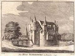 Copperplate engraving of "Huis Windenburg"
 -
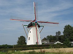 Windmill in Dreischor


This article about a location in Zeeland is a stub. You can help Wikipedia by expanding it. |