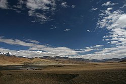
Maquan River
Appearance
| Maquan River | |
|---|---|
 | |
| Location | |
| Country | China |
| Region | Tibet Autonomous Region |
| Prefecture | Ngari |
| County | Burang |
| Physical characteristics | |
| Mouth | |
• coordinates | 29°36′00″N 84°9′00″E / 29.60000°N 84.15000°E |
Maquan River (马泉河, Dangque Zangbu, 当却藏布) is a river in China.[1] It is located in the Tibet Autonomous Region, in the southwestern part of the country, about 670 km (416 mi) west of the regional capital Lhasa.
The average annual rainfall is 561 mm (22.1 in). The rainiest month is July, with an average of 123 mm (4.8 in) rainfall, and the driest is April, with 14 mm (0.55 in) precipitation.[2]
References
- ^ "Maquan River". Retrieved 17 September 2019.
- ^ "NASA Earth Observations: Rainfall (1 month - TRMM)". NASA/Tropical Rainfall Monitoring Mission. Retrieved 30 January 2016.

