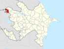
Bağanıs Ayrım
41°05′48″N 45°04′55″E / 41.09667°N 45.08194°E
Bağanis Ayrum | |
|---|---|
| Coordinates: 41°05′48″N 45°04′55″E / 41.09667°N 45.08194°E | |
| Country | Azerbaijan (controlled by Armenia) |
| Rayon | Qazakh |
| Time zone | UTC+4 (AZT) |
| • Summer (DST) | UTC+5 (AZT) |
Bağanis Ayrum (also, Bağanis Ayrım and Baganis Ayrum) is a village in the Qazakh Rayon of Azerbaijan. The name indicates the presence of Ayrums in the vicinity.
History
Capture and massacre
On 26 March 1990, during the First Nagorno-Karabakh War, the Armenian Armed Forces attacked and seized the village. The Armenian forces burned some 20 houses and massacred eleven Azerbaijani civilians.[1][2] According to Azerbaijani sources, a 39-days-old infant was burned alive by the Armenians.[3] The bodies of members of one family, including infants, were found in the charred ruins of their burned homes. By the time the Azerbaijani troops arrived in Bağanis Ayrum, the attackers had already fled.[4]
The village was ultimately seized several months later.[1]
References
- ^ a b Армения-Азербайджан: это уже просто война (in Russian). Kommersant. 20 August 1990. Retrieved 2010-05-27.
- ^ АРМЕНИЯ – АЗЕРБАЙДЖАН: ЭТО УЖЕ ПРОСТО ВОЙНА. Vlasts (in Russian). 20 August 1990.
- ^ Qazaxın işğal altında olan 7 kəndi haqqında nə bilirik? - (FOTOLAR+İLK DƏFƏ)
- ^ Cullen, Robert. "A Reporter at Large, Roots." The New Yorker. 15 April 1991.


