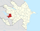
İmarət Qərvənd
40°09′55″N 46°26′57″E / 40.16528°N 46.44917°E
İmarət Qərvənd
Իմար • Imar | |
|---|---|
| Coordinates: 40°09′55″N 46°26′57″E / 40.16528°N 46.44917°E | |
| Country | |
| District | Kalbajar (de jure) |
| Province | Martakert (de facto) |
| Elevation | 1,155 m (3,789 ft) |
| Time zone | UTC+4 (AZT) |
İmarət Qərvənd (Imarat Garvand; Armenian: Իմար, romanized: Imar) is a village de jure in the Kalbajar District of Azerbaijan, de facto in the Martakert Province of the self-proclaimed Republic of Artsakh. The village had an Azerbaijani majority prior to their expulsion during the Nagorno-Karabakh war.[1]
The international civil rights society Memorial wrote about the forced exodus of the Azerbaijani inhabitants of the village in 1991, along with several other Azerbaijani villages around the area. The village was fully burned to the ground by Armenian forces.[2]
References
- ^ Андрей Зубов. "Андрей Зубов. Карабах: Мир и Война". drugoivzgliad.com.
- ^ "СОБЫТИЯ, ПРЕДШЕСТВУЮЩИЕ ШТУРМУ ХОДЖАЛЫ". memo.ru (in Russian). Memorial.


