Queenton, Queensland
| Queenton Charters Towers, Queensland | |||||||||||||||
|---|---|---|---|---|---|---|---|---|---|---|---|---|---|---|---|
 Bushland, Queenton, 2013 | |||||||||||||||
| Coordinates | 20°04′33″S 146°16′53″E / 20.07583°S 146.28139°E | ||||||||||||||
| Population | 1,702 (2011 census)[1] | ||||||||||||||
| Postcode(s) | 4820 | ||||||||||||||
| LGA(s) | Charters Towers Region | ||||||||||||||
| State electorate(s) | Traeger | ||||||||||||||
| Federal division(s) | Kennedy | ||||||||||||||
| |||||||||||||||
Queenton is a suburb of Charters Towers in the Charters Towers Region, Queensland, Australia.[2]
Geography
The Great Northern railway passes through Queenton from the north-east to the south-west with Charters Towers railway station within the locality. The railway line forms both part of the locality's north-eastern boundary and also part of its western boundary. The Flinders Highway forms a part of the locality's eastern boundary.[3]
The land is predominantly flat (approximately 300 metres above sea level), partly residential, partly old mine ruins, and partly undeveloped bushland.[3]
History

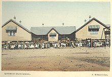
Queenton State School opened on 13 July 1891 and closed on 1 September 1931.[4]
In the 2011 census, Queenton had a population of 1,702 people.[1]
Heritage listings
Queenton has a number of heritage-listed sites, including:
- Enterprise Road: Signals, Crane and Subway, Charters Towers Railway Station[5]
- Charters Towers mine shafts[6]
- Stone kerbing, channels and footbridges of Charters Towers[7]
References
- ^ a b Australian Bureau of Statistics (31 October 2012). "Queenton (SSC)". 2011 Census QuickStats. Retrieved 21 June 2016.
- ^ "Queenton (entry 49632)". Queensland Place Names. Queensland Government. Retrieved 21 June 2016.
- ^ a b "Queensland Globe". State of Queensland. Retrieved 1 August 2017.
- ^ "Agency ID 9190, Queenton State School". Queensland State Archives. Retrieved 1 August 2017.
- ^ "Signals, Crane and Subway, Charters Towers Railway Station (entry 602627)". Queensland Heritage Register. Queensland Heritage Council. Retrieved 7 July 2013.
- ^ "Charters Towers Gold Mine Shafts and Remains (entry 602221)". Queensland Heritage Register. Queensland Heritage Council. Retrieved 7 July 2013.
- ^ "Stone kerbing, channels and footbridges of Charters Towers (entry 602512)". Queensland Heritage Register. Queensland Heritage Council. Retrieved 7 July 2013.
External links
- "Charters Towers Suburbs". Queensland Places. Centre for the Government of Queensland, University of Queensland. Retrieved 15 October 2017.

