
Väike-Maarja Parish
Väike-Maarja Parish
Väike-Maarja vald | |
|---|---|
.jpg) Kiltsi manor | |
 Flag  Coat of arms | |
 Väike-Maarja Parish within Lääne-Viru County. | |
| Country | |
| County | Lääne-Viru County |
| Administrative centre | Väike-Maarja |
| Area | |
| • Total | 457.39 km2 (176.60 sq mi) |
| Population (01.01.2009) | |
| • Total | 5,421 |
| • Density | 12/km2 (31/sq mi) |
| ISO 3166 code | EE-928 |
| Website | www.v-maarja.ee |
Väike-Maarja Parish (Estonian: Väike-Maarja vald) is a rural municipality of Estonia, in Lääne-Viru County. It has a population of 5,421 (as of 1 January 2009) and an area of 457.39 km².[1]
Settlements
- Small boroughs
- Villages
Aavere - Aburi - Äntu - Ärina - Avanduse - Avispea - Ebavere - Eipri - Hirla - Imukvere - Kamariku - Kännuküla - Kärsa - Käru - Koluvere - Koonu - Kurtna - Liivaküla - Määri - Müüriku - Nadalama - Nõmme - Orguse - Pandivere - Pikevere - Pudivere - Raeküla - Raigu - Rastla - Sandimetsa - Tammiku - Triigi - Uuemõisa - Vao - Varangu - Võivere - Vorsti
Notable natives
- Aile Asszonyi, operatic soprano
- Georg Lurich, wrestler
- Johann Peter Hoffmann, owner of "Marienhof"
Gallery
-
 Ruins of Aavere manor
 -
 Simuna church
 -
 Väike-Maarja church
 -
 Äntu Blue Lake
 -
 Stone bridge in Kiltsi manor park
 -
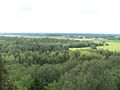 View from Ebavere Hill


International relations
Twin towns — Sister cities
 Hausjärvi, Finland (since 1989)[2]
 Kaarma, Estonia[2]
 Sirdal, Norway (since 1994)[2]
- Sonkajärvi, Finland (since 1997)[2]
 Tommerup, Denmark (1995–2007)[2]
References
- ^ "Population figure and composition". www.stat.ee Statistics Estonia. Retrieved 27 January 2010.
- ^ a b c d e "Sõprusvallad" (in Estonian). Väike-Maarja vald. Retrieved 21 March 2011.
External links
- Official website (in Estonian and English)
59°7′46″N 26°15′9″E / 59.12944°N 26.25250°E
| Urban municipalities | ||
|---|---|---|
| Rural municipalities | ||
This Lääne-Viru County location article is a stub. You can help Wikipedia by expanding it. |