Pohuwato Regency
Appearance
Pohuwato Regency | |
|---|---|
 | |
| Coordinates: 0° 31 59 N, 121° 49 30 E | |
| Country | Indonesia |
| Province | Gorontalo |
| Capital | Marisa |
| Area | |
• Total | 1,638.74 sq mi (4,244.31 km2) |
| Population (2010 Census) | |
• Total | 128,748 |
| • Density | 79/sq mi (30/km2) |
| Time zone | UTC+8:00 |
| • Summer (DST) | UTC+8:00 |
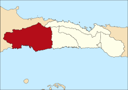
Pohuwato is a regency of Gorontalo Province, Indonesia. It is located on the island of Sulawesi. Its regency seat is Marisa. It was established in 2003 under Law Number (Undang-Undang Nomor) 6/2003. It has an area of 4,244.31 km2, and a population of 128,748 at the 2010 Census.
Administration
Pohuwato Regency is divided into thirteen districts (kecamatan), tabulated below with their areas and 2010 Census populations.[1]
| Name | Area in km2 |
Population Census 2010 |
|---|---|---|
| Popatato Barat (West Popayato) |
705.60 | 6,670 |
| Popayato | 158.50 | 9,169 |
| Popatato Timur (East Popayato) |
291.57 | 7,712 |
| Lemito | 498.24 | 10,488 |
| Wanggarasi | 472.08 | 4,573 |
| Randangan | 189.98 | 14,995 |
| Taluditi | 693.59 | 7,248 |
| Pantilanggio | 342.91 | 8,686 |
| Buntulia | 501.15 | 10,494 |
| Duhiadaa | 37.53 | 10,662 |
| Marisa | 29.19 | 17,680 |
| Paguat | 67.12 | 14,967 |
| Dengilo | 366.87 | 5,404 |
References
- ^ Biro Pusat Statistik, Jakarta, 2011.
0°31′59″N 121°49′30″E / 0.53306°N 121.82500°E

