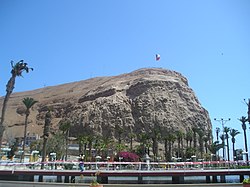
Morro de Arica
Appearance

Morro de Arica is a steep hill located in the Chilean city of Arica. Its height is 139 metres above sea level. It was the last bulwark of defense for the Peruvian troops who garrisoned the city during the War of the Pacific (1879–1883). Morro de Arica was assaulted and captured on June 7, 1880 by Chilean troops in the last part of the Tacna and Arica campaign.[1] Morro de Arica rises steeply from the city and the sea, with a more gentle slope towards the east. A giant flag of Chile is flown on its summit. From the top it is possible to look northwards along the coast as far as to Peru. Morro de Arica was declared a national monument on October 6, 1971.[2]
Wikimedia Commons has media related to Morro de Arica.
18°28′49″S 70°19′25″W / 18.48028°S 70.32361°W
References
- ^ Pinochet Ugarte, Augusto; Villaroel Carmona, Rafael; Lepe Orellana, Jaime; Fuente-Alba Poblete, J. Miguel; Fuenzalida Helms, Eduardo (1997) [1984]. Historia militar de Chile (in Spanish). Vol. II (3rd ed.). Biblioteca Militar. pp. 165–166.
- ^ "Morro de Arica". Consejo de Monumentos Nacionales de Chile (in Spanish). Retrieved 5 March 2020.
