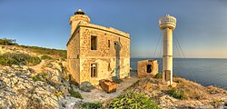
Punta del Diavolo Lighthouse
 Punta del Diavolo Lighthouse in 2013 | |
 | |
| Location | San Domino Apulia Italy |
|---|---|
| Coordinates | 42°06′24″N 15°28′38″E / 42.106546°N 15.477274°E |
| Tower | |
| Constructed | 1905 (first) |
| Foundation | concrete base (current) |
| Construction | stone tower (first) fibreglass (current) |
| Automated | yes |
| Height | 9 metres (30 ft) (first) 4 metres (13 ft) (current) |
| Shape | octagonal prism tower with balcony and lantern (first) cylindrical tower with small balcony and light (current) |
| Markings | white tower, grey metallic lantern dome (first) white tower (current) |
| Power source | solar power |
| Operator | Marina Militare[1][2] |
| Light | |
| First lit | 1990s. |
| Deactivated | 1987 (first) |
| Focal height | 48 metres (157 ft) (current) |
| Light source | solar power |
| Range | 11 nautical miles (20 km; 13 mi) |
| Characteristic | Fl (3) W 10s. |
| Italy no. | 3844 E.F. |
Punta del Diavolo Lighthouse (Italian: Faro di Punta del Diavolo) is an active lighthouse located on the western point of Isola San Domino, one of the Tremiti in Apulia on the Adriatic Sea.
Description
The first lighthouse was built in 1905 and consists of a white octagonal prism stone tower, 9 feet (2.7 m) high, with balcony and lantern, rising from a 2-storey white keeper's house. On November 8, 1987 a mysterious explosion damaged the lighthouse, but the keeper, Domenico Calabrese, was off duty and survived. The lighthouse remained inactive until the 1990s. when a new white cylindrical fibreglass tower, 4 metres (13 ft) high, with light and gallery was established. The lantern, positioned at 48 metres (157 ft) above sea level, emits three white flashes in a 10 seconds period, visible up to a distance of 11 nautical miles (20 km; 13 mi). The lighthouse is completely automated, powered by a solar unit and is managed by the Marina Militare with the identification code number 3844 E.F.[2][3][4]
See also
References
- ^ "Lighthouses of Italy: Northern Puglia". The Lighthouse Directory. Retrieved March 6, 2018.
- ^ a b "Molfetta Lighthouse". Marina Militare. Retrieved March 6, 2018.
- ^ "Il Demanio mette in vendita". Corriere del Mezzogiorno. Retrieved March 6, 2018.
- ^ "Il vecchio faro abbandonato". La Gazzetta del Mezzogiorno. Retrieved March 6, 2018.
External links
