Sungai Penuh
Sungai Penuh | |
|---|---|
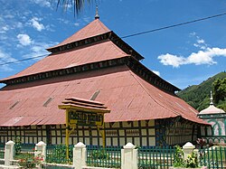
 Agung Mosque, built in 1874 | |
 Location within Jambi | |
| Coordinates: 2°3′32″S 101°23′29″E / 2.05889°S 101.39139°E | |
| Country | |
| Province | |
| Government | |
| • Mayor | Asafri Jaya Bakri |
| • Vice Mayor | Zulhelmi |
| Area | |
• Total | 391.5 km2 (151.2 sq mi) |
| Population (2019) | |
• Total | 88,321 |
| • Density | 230/km2 (580/sq mi) |
| [1] | |
| Time zone | UTC+7 (Indonesia Western Time) |
| Postcodes | 3xxxx |
| Area code | (+62) 748 |
| Vehicle registration | BH |
| Website | sungaipenuhkota.go.id |
Sungai Penuh (Template:Lang-id) is a city in Indonesia, in Jambi province, on the island of Sumatra. It is an enclave within Kerinci Regency, of which it was formerly part but from which it is now administratively separate. The city, whose name means "Penuh River", covers an area of 391.50 km2 and had a population of 82,293 at the 2010 Census and 87,032 at the 2015 Census; the latest official estimate (as at mid 2019) is 88,321.[2]
Administrative districts
At the 2010 Census there were five districts (kecamatan), but three more were added subsequently. The eight districts currently forming the city are listed below with their areas and populations at the 2010 Censuses and according to the latest (2016) available estimates.[3]
| Name | Area in sq.km. |
Population Census 2010 |
Population Estimate 2016 |
|---|---|---|---|
| Tanah Kampung | 11.00 | 8,396 | 8,689 |
| Kumun Debai | 142.00 | 8,421 | 8,577 |
| Sungai Penuh (district) | 3.35 | 35,067 | 9,996 |
| Sungai Bungkal (Bungkal River) |
111.00 | (a) | 10,125 |
| Pondok Tinggi | 91.00 | (a) | 17,061 |
| Hamparan Rawang | 12.10 | 12,726 | 13,950 |
| Pesisir Bukit | 19.50 | 17,683 | 11,163 |
| Koto Baru | 1.64 | (a) | 8,410 |
| Total city | 391.50 | 82,293 | 87,971 |
Note:
(a) The 2010 population of these new districts are included with that of the existing districts from which they were cut out in 2013.
References
- (in Indonesian) https://web.archive.org/web/20101013091507/http://www.bps.go.id/aboutus.php?hasilSP2010=1


