
Piatykhatky, Dnipropetrovsk Oblast
Piatykhatky
П'ятихатки | |
|---|---|
 Piatykhatky railway station | |
 Flag  Coat of arms | |
 Piatykhatky Location of Piatykhatky | |
| Coordinates: 48°24′49″N 33°42′10″E / 48.41361°N 33.70278°E | |
| Country Oblast Raion | Ukraine Dnipropetrovsk Oblast Piatykhatki Raion |
| Founded | 1886 |
| City rights | 1938 |
| Area | |
| • Total | 1,838 km2 (710 sq mi) |
| Population (2020) | |
| • Total | 18,619 |
| • Density | 10/km2 (26/sq mi) |
| Postal code | 52100-52109 |
| Area code | +380 5651 |
Piatykhatky (Ukrainian: П'ятихатки [pjɐtɪˈxɑtkɪ], lit. ''Five houses'') is a small city and a large railway junction in Dnipropetrovsk Oblast (province) of Ukraine. It serves as the administrative center of Piatykhatky Raion. Population: 18,619 (2020 est.)[1]. Population in 2001 was 20,563.
Gallery
-
 Train monument
 -
 Sailors' monument
 -
 Holodomor memorial in Piatykhatky
 -
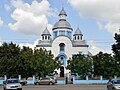 Piatykhatky church
 -
 A street in Piatykhatky


References
Notes
- ^ Чисельність наявного населення України на 1 січня 2020 року / Population of Ukraine Number of Existing as of January 1, 2020 (PDF) (in Ukrainian and English). Kyiv: State Statistics Service of Ukraine. Archived (PDF) from the original on 28 September 2023.
Sources
- "Registration card in Verknovna Rada website" (in Ukrainian). Archived from the original on 15 June 2012. Retrieved 2 October 2011.
Wikimedia Commons has media related to Piatykhatky.
This article about a location in Dnipropetrovsk Oblast is a stub. You can help Wikipedia by expanding it. |