
Cairo Ohio River Bridge
Cairo Ohio River Bridge | |
|---|---|
 | |
| Coordinates | 36°59′37″N 89°08′46″W / 36.9935°N 89.1462°W |
| Carries | 2 lanes of |
| Crosses | Ohio River |
| Locale | Wickliffe, Kentucky and Cairo, Illinois |
| Maintained by | Kentucky Transportation Cabinet |
| Characteristics | |
| Design | Cantilever bridge |
| Total length | 5,863.7 feet (1,787.3 m) |
| Width | 20 feet (6.1 m) |
| Longest span | 800 feet (240 m) |
| Clearance above | 19.6 feet (6.0 m) |
| History | |
| Opened | 1937 |
| Location | |
 | |
The Cairo Ohio River Bridge is a cantilever bridge carrying U.S. Route 51, U.S. Route 60, and U.S. Route 62[1] across the Ohio River between Wickliffe, Kentucky[1] and Cairo, Illinois. Of all the Ohio River crossings, it is the furthest downstream; the Mississippi River can be seen while crossing the bridge and looking westward.
This is an authorized truck route.
History
Construction was awarded to Modjeski and Masters and the Mt. Vernon Bridge Co.[2] It was finished in 1937 and rehabilitated in 1979. Today the Cairo Ohio River Bridge is eligible for listing on the National Register of Historic Places.[2]
See also
External links
- Cairo Ohio River Bridge (US 51, US 60, US 62) at Bridges & Tunnels
-
 At sunset
 -
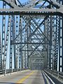 Steel framing
 -
 Eastern spans


.JPG)
Bridges of the Ohio River | ||||
|---|---|---|---|---|
| ||||
References
- ^ a b Missourian, Southeastern. "Ohio River bridge between Cairo, Wickliffe reopens". Southeast Missourian. Retrieved 3 September 2012.
- ^ a b "Cairo Ohio River Bridge". Bridgehunter.com. Retrieved 3 September 2012.
This article about a bridge in Kentucky is a stub. You can help Wikipedia by expanding it. |
This article about a bridge in Illinois is a stub. You can help Wikipedia by expanding it. |
This article relating to the United States Numbered Highway System is a stub. You can help Wikipedia by expanding it. |
- Road bridges in Illinois
- Bridges of the United States Numbered Highway System
- Bridges over the Ohio River
- U.S. Route 51
- U.S. Route 60
- U.S. Route 62
- Buildings and structures in Ballard County, Kentucky
- Cairo, Illinois
- Bridges completed in 1937
- Bridges in Alexander County, Illinois
- Road bridges in Kentucky
- Great River Road
- Steel bridges in the United States
- Cantilever bridges in the United States
- Southern United States bridge (structure) stubs
- Kentucky building and structure stubs
- Kentucky transportation stubs
- Illinois bridge (structure) stubs
- United States Numbered Highways stubs