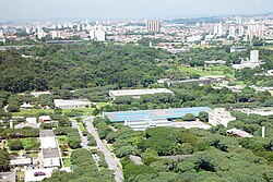
Butantã (district of São Paulo)
Appearance
Butantã | |
|---|---|
 The location of Butantã district in São Paulo | |
 | |
| Country | Brazil |
| State | São Paulo |
| City | São Paulo |
| Government | |
| • Type | Subprefecture |
| • Subprefect | Daniel Barbosa Rodrigueiro |
| Area | |
| • Total | 12.5 km2 (4.8 sq mi) |
| Population (2000) | |
| • Total | 52.649 |
| HDI | 0.928 –high |
| Website | Subprefecture of Butantã |
Butantã (Portuguese pronunciation: [butɐ̃ˈtɐ̃], from the tupi for "crushed soil") is a district of the city of São Paulo, Brazil. It is part of the homonymous subprefecture, located on the west bank of the Pinheiros River.
The district hosts the main campus of the University of São Paulo.
The Instituto Butantan is also located in the borough.

