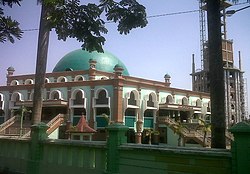
Sumber, Cirebon
Appearance
جحح
Sumber
dfghjk qwertyuiop | |
|---|---|
| Regional transcription(s) | |
| • Sundanese | ᮞᮥᮙ᮪ᮘᮨᮁ |
| • Javanese | ꦯꦸꦩ꧀ꦧꦺꦂ |
 Grand Mosque of Sumber | |
| Coordinates: 6°45′16″S 108°29′9″E / 6.75444°S 108.48583°E | |
| Country | |
| Province | West Java |
| Regency | Cirebon Regency |
| Government | |
| • Camat | Iman Santoso |
| • Secretary | Carmin |
| Area | |
| • Total | 25.65 km2 (9.90 sq mi) |
| Elevation | 66 m (217 ft) |
| Population (2020)[1] | |
| • Total | 90,891 |
| • Density | 3,500/km2 (9,200/sq mi) |
| Time zone | UTC+7 (IWT) |
| Postal code | 4561x |
| Area code | (+62) 231 |
| Villages | 14 |
| Website | Official website |
Sumber (Template:Lang-su; Template:Lang-jv) is a district which serves as the regency seat of the Cirebon Regency of West Java, Indonesia. It is divided into 14 villages which are as follows:[1]
- Babakan
- Gegunung
- Kaliwadas
- Kemantren
- Kenanga
- Matangaji
- Pasalakan
- Pejambon
- Perbutulan
- Sendang
- Sidawangi
- Sumber
- Tukmudal
- Watubelah
Climate
Sumber has a tropical monsoon climate (Am) with moderate to little rainfall from June to October and heavy to very heavy rainfall from November to May.
| Climate data for Sumber | |||||||||||||
|---|---|---|---|---|---|---|---|---|---|---|---|---|---|
| Month | Jan | Feb | Mar | Apr | May | Jun | Jul | Aug | Sep | Oct | Nov | Dec | Year |
| Mean daily maximum °C (°F) | 30.9 (87.6) |
30.7 (87.3) |
31.2 (88.2) |
31.7 (89.1) |
32.0 (89.6) |
32.0 (89.6) |
32.1 (89.8) |
32.6 (90.7) |
33.3 (91.9) |
33.6 (92.5) |
32.5 (90.5) |
31.6 (88.9) |
32.0 (89.6) |
| Daily mean °C (°F) | 26.6 (79.9) |
26.4 (79.5) |
26.7 (80.1) |
27.1 (80.8) |
27.3 (81.1) |
27.0 (80.6) |
27.0 (80.6) |
27.1 (80.8) |
27.5 (81.5) |
27.9 (82.2) |
27.4 (81.3) |
26.9 (80.4) |
27.1 (80.7) |
| Mean daily minimum °C (°F) | 22.3 (72.1) |
22.2 (72.0) |
22.3 (72.1) |
22.5 (72.5) |
22.6 (72.7) |
22.0 (71.6) |
21.9 (71.4) |
21.6 (70.9) |
21.7 (71.1) |
22.2 (72.0) |
22.4 (72.3) |
23.3 (73.9) |
22.3 (72.1) |
| Average rainfall mm (inches) | 499 (19.6) |
416 (16.4) |
412 (16.2) |
218 (8.6) |
157 (6.2) |
80 (3.1) |
61 (2.4) |
44 (1.7) |
29 (1.1) |
73 (2.9) |
226 (8.9) |
360 (14.2) |
2,575 (101.3) |
| Source: Climate-Data.org[2] | |||||||||||||
References
- ^ a b c d "Sumber Subdistrict in Figures 2020". Statistics Indonesia. Retrieved December 9, 2020.
- ^ "Climate: Sumber". Climate-Data.org. Retrieved 12 November 2020.


