Chexbres-Village railway station
Appearance
Chexbres-Village | |||||||||||
|---|---|---|---|---|---|---|---|---|---|---|---|
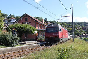
 A diverted InterRegio at the station in 2009 | |||||||||||
| General information | |||||||||||
| Location | Chexbres Switzerland | ||||||||||
| Coordinates | 46°28′51.8016″N 6°46′42.7634″E / 46.481056000°N 6.778545389°E | ||||||||||
| Elevation | 560 m (1,840 ft) | ||||||||||
| Owned by | Swiss Federal Railways | ||||||||||
| Line(s) | Vevey–Chexbres line | ||||||||||
| Distance | 5.6 km (3.5 mi) from Vevey[1] | ||||||||||
| Train operators | Swiss Federal Railways | ||||||||||
| Connections | CarPostal Suisse buses[2] | ||||||||||
| Services | |||||||||||
| |||||||||||
| |||||||||||
Chexbres-Village railway station (Template:Lang-fr) is a railway station in the municipality of Chexbres, in the Swiss canton of Vaud. It is an intermediate stop on the standard gauge Vevey–Chexbres line of Swiss Federal Railways.[1]
Services
The following services stop at Chexbres-Village:[3]
References
- ^ a b Eisenbahnatlas Schweiz. Cologne: Schweers + Wall. 2012. p. 42. ISBN 978-3-89494-130-7.
- ^ "Reseau CarPostal Ouest" (PDF) (in French). PostBus Switzerland. 15 December 2019. Archived from the original (PDF) on 4 July 2020. Retrieved 6 July 2020.
- ^ "Vevey - Puidoux-Chexbres (Train des Vignes)" (PDF) (in French). Bundesamt für Verkehr. 3 October 2019. Retrieved 6 July 2020.
External links
 Media related to Chexbres-Village railway station at Wikimedia Commons
- Chexbres-Village railway station – SBB


