Hardendale
Appearance
| Hardendale | |
|---|---|
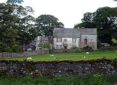
 Hardendale Hall | |
| OS grid reference | NY581146 |
| Civil parish | |
| District | |
| Shire county | |
| Region | |
| Country | England |
| Sovereign state | United Kingdom |
| Post town | PENRITH |
| Postcode district | CA10 |
| Dialling code | 01931 |
| Police | Cumbria |
| Fire | Cumbria |
| Ambulance | North West |
| UK Parliament | |
Hardendale is a hamlet in the parish of Shap Rural in the Eden District, in the county of Cumbria, England, near Shap and junction 39 of the M6 motorway.[1] It is also near the hamlet of Oddendale.
References
[edit]Wikimedia Commons has media related to Hardendale.


