Crail railway station
Appearance
Crail | |
|---|---|
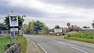
 The site of the station, looking southwest, in 1988 | |
| General information | |
| Location | Crail, Fife Scotland |
| Coordinates | 56°15′45″N 2°37′57″W / 56.2624°N 2.6325°W |
| Grid reference | NO609079 |
| Platforms | 2 |
| Other information | |
| Status | Disused |
| History | |
| Original company | Anstruther and St Andrews Railway |
| Pre-grouping | North British Railway |
| Post-grouping | LNER |
| Key dates | |
| 1 September 1883 | Opened |
| 6 September 1965 | Closed to passengers |
| 18 November 1966 | Closed to goods |
Crail railway station served the burgh of Crail, Fife, Scotland from 1883 to 1966 on the Fife Coast Railway.
History
The station opened on 1 September 1883 by the North British Railway. It closed to both passengers on 6 September 1965[1][2] and closed to goods on 18 November 1966.[3]
References
- ^ Historic Environment Scotland. "Crail Station (98297)". Canmore. Retrieved 29 March 2018.
- ^ Quick, M E (2002). Railway passenger stations in England, Scotland and Wales - a chronology. Richmond: Railway and Canal Historical Society. p. 139. OCLC 931112387.
- ^ "Entering Crail near site of station,... © Ben Brooksbank :: Geograph Britain and Ireland". Geograph. Retrieved 24 February 2021.
External links
| Preceding station | Disused railways | Following station | ||
|---|---|---|---|---|
| Kingsbarns Line and station closed |
Fife Coast Railway | Anstruther Line and station closed |
